Merchantville, New Jersey facts for kids
Quick facts for kids
Merchantville, New Jersey
|
||
|---|---|---|
|
Borough
|
||
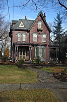
Cattell Tract Historic District
|
||
|
||
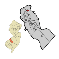
Merchantville highlighted in Camden County. Inset: Location of Camden County in the State of New Jersey
|
||
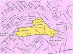
Census Bureau map of Merchantville, New Jersey
|
||
| Country | ||
| State | ||
| County | Camden | |
| Incorporated | March 3, 1874 | |
| Government | ||
| • Type | Borough | |
| • Body | Borough Council | |
| Area | ||
| • Total | 0.59 sq mi (1.54 km2) | |
| • Land | 0.59 sq mi (1.54 km2) | |
| • Water | 0.00 sq mi (0.00 km2) 0.00% | |
| Area rank | 542nd of 565 in state 31st of 37 in county |
|
| Elevation | 82 ft (25 m) | |
| Population
(2020)
|
||
| • Total | 3,820 | |
| • Estimate
(2023)
|
3,823 | |
| • Rank | 419th of 565 in state 27th of 37 in county |
|
| • Density | 6,437.0/sq mi (2,485.3/km2) | |
| • Density rank | 83rd of 565 in state 5th of 37 in county |
|
| Time zone | UTC−05:00 (Eastern (EST)) | |
| • Summer (DST) | UTC−04:00 (Eastern (EDT)) | |
| ZIP Code |
08109
|
|
| Area code | 856 | |
| FIPS code | 3400745510 | |
| GNIS feature ID | 0885297 | |
| Website | ||
Merchantville is a small town, called a borough, located in Camden County, in the state of New Jersey. In 2020, about 3,820 people lived there.
Contents
History of Merchantville
Merchantville officially became a borough on March 3, 1874. It was formed from parts of other nearby areas.
How Merchantville Got Its Name
The name 'Merchantville' has an interesting story. Some say it came from a family named Merchant. However, a local historian, Francis F. Eastlack, shared another tale. He said that four men who helped develop the town—Matthias Homer, John Louty, Samuel McFadden, and Frederick Gerker—were meeting to decide on a name. Since all four were merchants, someone suggested, "Gentlemen, as you are all merchants, why not call it Merchantville?"
Geography and Location
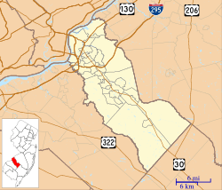
Merchantville is a small area, covering about 0.59 square miles (1.54 square kilometers) of land. There is no water within its borders.
Neighboring Towns
The borough shares its borders with two other towns in Camden County: Cherry Hill and Pennsauken Township.
People and Population
| Historical population | |||
|---|---|---|---|
| Census | Pop. | %± | |
| 1870 | 245 | — | |
| 1880 | 439 | 79.2% | |
| 1890 | 1,225 | 179.0% | |
| 1900 | 1,608 | 31.3% | |
| 1910 | 1,996 | 24.1% | |
| 1920 | 2,749 | 37.7% | |
| 1930 | 3,592 | 30.7% | |
| 1940 | 3,679 | 2.4% | |
| 1950 | 4,183 | 13.7% | |
| 1960 | 4,075 | −2.6% | |
| 1970 | 4,425 | 8.6% | |
| 1980 | 3,972 | −10.2% | |
| 1990 | 4,095 | 3.1% | |
| 2000 | 3,801 | −7.2% | |
| 2010 | 3,821 | 0.5% | |
| 2020 | 3,820 | 0.0% | |
| 2023 (est.) | 3,823 | 0.1% | |
| Population sources:1870 1880–2000 1880–1920 1880–1890 1890–1910 1910–1930 1940–2000 2000 2010 2020 |
|||
Population in 2010
In 2010, the town had 3,821 people living in 1,574 homes. About 966 of these were families. The population was made up of different groups: about 76.6% White, 13% Black or African American, 2.3% Asian, and 4.4% from other backgrounds. About 11.6% of the population was Hispanic or Latino.
About 28.5% of homes had children under 18. The average home had 2.41 people. The average family had 3.09 people. The median age in Merchantville was 38.6 years old.
Education in Merchantville
Students in Merchantville attend public schools from pre-kindergarten through eighth grade. They go to Merchantville Elementary School.
High School Education
For high school, students from Merchantville attend Haddon Heights Junior/Senior High School. This is part of a special agreement between the school districts.
Merchantville used to have its own high school, Merchantville High School, until 1972. After it closed, students went to Pennsauken High School. In 2012, the Merchantville School District decided to switch to Haddon Heights High. This change was approved, and students started going to Haddon Heights in September 2015. Students who were already at Pennsauken High continued there until they graduated.
Private School Option
St. Peter School is a private elementary school in Merchantville. It teaches students from kindergarten through eighth grade. This school opened in 1927 and is part of the Roman Catholic Diocese of Camden.
Transportation
Merchantville has about 12.84 miles of roads. Most of these roads are maintained by the town itself.
Major Roads
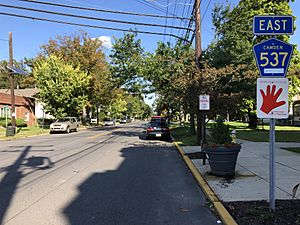
No major interstate highways or U.S. routes go directly through Merchantville. However, U.S. Route 130 passes very close to the western edge of the borough. The most important road that goes through Merchantville is County Route 537.
Public Transport Options
NJ Transit provides bus service in Merchantville. You can take routes 404, 405, and 407. These buses go to Camden, where you can connect to other bus and train services to reach Philadelphia. Passenger train service to Merchantville stopped in the late 1960s.
Notable People from Merchantville
Many interesting people have lived in or are connected to Merchantville.
- Alfred L. Banyard (1908–1992), a bishop in the Episcopal Diocese of New Jersey.
- Al Besselink (1923–2017), a professional golfer.
- Alexander G. Cattell (1816–1894), an early developer of Merchantville and a U.S. Senator for New Jersey.
- George Arthur Crump (1871–1918), known for designing the famous Pine Valley Golf Club.
- George Dempsey (1929–2017), a professional basketball player.
- Don Evans (1938–2003), an African-American playwright, director, actor, and educator.
- William Joseph Fallon (born 1944), a high-ranking admiral in the United States Navy.
- Charles G. Garrison (1849–1924), a physician, lawyer, and judge on the New Jersey Supreme Court.
- Bob Greacen (born 1947), a former professional basketball player.
- Hannah Hidalgo (born 2005), a college basketball player.
- Burrell Ives Humphreys (born 1927), a former judge and prosecutor.
- John Kasper (1929–1998), a figure involved in the civil rights movement.
- Greg Mark (born 1967), a former professional football player.
- Francis F. Patterson Jr. (1867–1935), a politician who served in the U.S. House of Representatives.
- William T. Read (1878–1954), a lawyer and politician, including Treasurer of New Jersey.
- Stephen H. Sholes (1911–1968), a record industry executive who signed Elvis Presley.
- Albert W. Van Duzer (1917–1999), a bishop in the Episcopal Diocese of New Jersey.
- Ethan Van Sciver (born 1974), a comics artist.
- Jersey Joe Walcott (1914–1994), a world heavyweight boxing champion and Sheriff of Camden County.
- Dr. Wyatt Tee Walker (1928–2018), a pastor and civil rights leader.
- Bruce A. Wallace (1905–1977), a politician who served in the New Jersey Senate.
- Charles A. Wolverton (1880–1969), a politician who served in the U.S. House of Representatives for many years.
See also
 In Spanish: Merchantville para niños
 | Aaron Henry |
 | T. R. M. Howard |
 | Jesse Jackson |


