
Richlandtown, Pennsylvania facts for kids
Quick facts for kids
Richlandtown, Pennsylvania
|
|
|---|---|

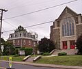
Main Street in Richlandtown
|
|

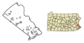
Location in Bucks County, Pennsylvania
|
|

Richlandtown, Pennsylvania
Location in Pennsylvania

Richlandtown, Pennsylvania
Location in the United States
|
|
| Country | United States |
| State | Pennsylvania |
| County | Bucks |
| Area | |
| • Total | 0.26 sq mi (0.67 km2) |
| • Land | 0.26 sq mi (0.67 km2) |
| • Water | 0.00 sq mi (0.00 km2) |
| Elevation | 545 ft (166 m) |
| Population
(2020)
|
|
| • Total | 1,353 |
| • Density | 5,203.85/sq mi (2,006.58/km2) |
| Time zone | UTC-5 (Eastern (EST)) |
| • Summer (DST) | UTC-4 (EDT) |
| ZIP code |
18955
|
| Area codes | 215, 267, and 445 |
| FIPS code | 42-64584 |
Richlandtown is a small town, also called a borough, located in Bucks County, Pennsylvania, in the United States. In 2020, about 1,260 people lived there. It's a cozy place surrounded by Richland Township.
Contents
Where is Richlandtown?
Richlandtown is located at about 40.47 degrees North latitude and 75.32 degrees West longitude. Imagine a tiny square on a map; that's Richlandtown! It's completely surrounded by another area called Richland Township.
The United States Census Bureau says that Richlandtown is very small. It covers an area of about 0.2 square miles (0.67 square kilometers), and all of it is land. There are no big lakes or rivers inside the borough limits.
Who Lives in Richlandtown?
| Historical population | |||
|---|---|---|---|
| Census | Pop. | %± | |
| 1880 | 272 | — | |
| 1900 | 285 | — | |
| 1910 | 562 | 97.2% | |
| 1920 | 589 | 4.8% | |
| 1930 | 642 | 9.0% | |
| 1940 | 628 | −2.2% | |
| 1950 | 762 | 21.3% | |
| 1960 | 741 | −2.8% | |
| 1970 | 856 | 15.5% | |
| 1980 | 1,180 | 37.9% | |
| 1990 | 1,195 | 1.3% | |
| 2000 | 1,283 | 7.4% | |
| 2010 | 1,327 | 3.4% | |
| 2020 | 1,260 | −5.0% | |
| Sources: | |||
In 2020, a census (a count of people) showed that 1,260 people lived in Richlandtown. There were 467 households, which means 467 homes where people lived.
Most of the people living in Richlandtown are White (93%). About 5% are African American, and a small number are Asian or from other backgrounds. About 1.25% of the population is Hispanic or Latino.
Many homes (41.6%) had children under 18 living there. Most households (63%) were married couples living together. The average household had about 2.7 people.
The people in Richlandtown are of different ages. About 27% are under 18 years old. The median age, which is the middle age of all the people, was 35 years old. This means half the people were younger than 35 and half were older.
What is the Weather Like?
Richlandtown has a climate with hot summers. This means it gets quite warm in the summer, but it also has cold winters.
- Summer: Even though most summer days are a bit humid, sometimes it can get very hot and sticky. The highest temperature ever recorded was 102 degrees Fahrenheit (38.9 degrees Celsius) on July 22, 2011.
- Winter: Winters can be very cold. The coldest temperature recorded was -16.5 degrees Fahrenheit (-26.9 degrees Celsius) on January 21, 1994. Sometimes, there are big snowstorms, especially from December to February. The area usually gets between 30 to 36 inches (76 to 91 cm) of snow each year.
| Climate data for Richland, Elevation 499 ft (152 m), 1981-2010 normals, extremes 1981-2018 | |||||||||||||
|---|---|---|---|---|---|---|---|---|---|---|---|---|---|
| Month | Jan | Feb | Mar | Apr | May | Jun | Jul | Aug | Sep | Oct | Nov | Dec | Year |
| Record high °F (°C) | 68.0 (20.0) |
79.4 (26.3) |
86.4 (30.2) |
91.5 (33.1) |
93.6 (34.2) |
95.4 (35.2) |
102.0 (38.9) |
98.5 (36.9) |
95.7 (35.4) |
89.4 (31.9) |
78.5 (25.8) |
72.9 (22.7) |
102.0 (38.9) |
| Mean daily maximum °F (°C) | 37.5 (3.1) |
40.7 (4.8) |
49.9 (9.9) |
62.0 (16.7) |
72.0 (22.2) |
80.7 (27.1) |
84.8 (29.3) |
83.2 (28.4) |
75.9 (24.4) |
64.7 (18.2) |
53.2 (11.8) |
41.3 (5.2) |
62.3 (16.8) |
| Daily mean °F (°C) | 29.2 (−1.6) |
31.7 (−0.2) |
39.9 (4.4) |
50.7 (10.4) |
60.6 (15.9) |
69.7 (20.9) |
74.0 (23.3) |
72.4 (22.4) |
65.0 (18.3) |
53.6 (12.0) |
43.6 (6.4) |
33.3 (0.7) |
52.1 (11.2) |
| Mean daily minimum °F (°C) | 21.0 (−6.1) |
22.7 (−5.2) |
29.9 (−1.2) |
39.5 (4.2) |
49.2 (9.6) |
58.8 (14.9) |
63.1 (17.3) |
61.7 (16.5) |
54.1 (12.3) |
42.6 (5.9) |
34.0 (1.1) |
25.3 (−3.7) |
41.9 (5.5) |
| Record low °F (°C) | −16.5 (−26.9) |
−5.7 (−20.9) |
0.8 (−17.3) |
15.5 (−9.2) |
32.5 (0.3) |
39.5 (4.2) |
46.8 (8.2) |
41.2 (5.1) |
34.7 (1.5) |
23.5 (−4.7) |
13.2 (−10.4) |
−3.2 (−19.6) |
−16.5 (−26.9) |
| Average precipitation inches (mm) | 3.08 (78) |
2.70 (69) |
3.64 (92) |
3.85 (98) |
4.07 (103) |
4.32 (110) |
4.04 (103) |
3.41 (87) |
4.13 (105) |
3.81 (97) |
3.69 (94) |
3.49 (89) |
44.23 (1,123) |
| Average relative humidity (%) | 68.4 | 65.9 | 60.2 | 60.0 | 64.3 | 69.3 | 69.5 | 72.1 | 72.9 | 70.9 | 69.8 | 71.3 | 67.9 |
| Average dew point °F (°C) | 20.1 (−6.6) |
21.6 (−5.8) |
27.2 (−2.7) |
37.3 (2.9) |
48.5 (9.2) |
59.2 (15.1) |
63.4 (17.4) |
62.9 (17.2) |
56.1 (13.4) |
44.4 (6.9) |
34.4 (1.3) |
25.0 (−3.9) |
41.8 (5.4) |
| Source: PRISM | |||||||||||||
Education in Richlandtown
Students in Richlandtown go to public schools that are part of the Quakertown Community School District.
- Elementary School: Kids in kindergarten through 5th grade attend Neidig Elementary School, which is in the nearby borough of Quakertown.
- Middle School: Sixth graders go to the Sixth Grade Center. Students in 7th and 8th grade attend Strayer Middle School.
- High School: For grades 9 through 12, students go to Quakertown Community High School.
How to Get Around?
_just_east_of_Main_Street_in_Richlandtown,_Bucks_County,_Pennsylvania.jpg)
Richlandtown has about 3.42 miles (5.5 km) of public roads. Some of these roads are taken care of by the Pennsylvania Department of Transportation (PennDOT), and others are maintained by the borough itself.
The main highway that goes through Richlandtown is Pennsylvania Route 212. It runs through the southern part of the borough, following streets like Main Street and Church Street.
Images for kids
-
Main Street in Richlandtown
-
Location in Bucks County, Pennsylvania
-

PA 212 northbound in Richlandtown
See also
 In Spanish: Richlandtown para niños
