
Silverdale, Pennsylvania facts for kids
Quick facts for kids
Silverdale, Pennsylvania
|
|
|---|---|

Silverdale Municipal Building
|
|

Location in Bucks County, Pennsylvania.
|
|

Silverdale, Pennsylvania
Location in Pennsylvania

Silverdale, Pennsylvania
Location in the United States
|
|
| Country | United States |
| State | Pennsylvania |
| County | Bucks |
| Area | |
| • Total | 0.41 sq mi (1.07 km2) |
| • Land | 0.41 sq mi (1.07 km2) |
| • Water | 0.00 sq mi (0.00 km2) |
| Elevation | 443 ft (135 m) |
| Population
(2010)
|
|
| • Total | 4,249 |
| • Estimate
(2019)
|
854 |
| • Density | 2,067.80/sq mi (797.56/km2) |
| Time zone | UTC-5 (Eastern (EST)) |
| • Summer (DST) | UTC-4 (EDT) |
| Zip Code |
18962
|
| Area code(s) | 215, 267 and 445 |
| FIPS code | 42-70744 |
Silverdale is a small town, also called a borough, located in Bucks County, Pennsylvania, in the United States. In 2010, about 871 people lived here.
Contents
About Silverdale
Where is Silverdale?
Silverdale is found at coordinates 40°20′47″N 75°16′15″W / 40.34639°N 75.27083°W. This means it's in a specific spot on the map. The town covers a total area of about 0.4 square miles (1.07 square kilometers). All of this area is land, with no large bodies of water.
Learning in Silverdale
Kids in Silverdale go to schools that are part of the Pennridge School District. This district helps make sure students get a good education.
Who Lives in Silverdale?
The number of people living in Silverdale changes over time.
| Historical population | |||
|---|---|---|---|
| Census | Pop. | %± | |
| 2000 | 1,001 | — | |
| 2010 | 871 | −13.0% | |
| 2020 | 805 | −7.6% | |
In 2010, most people living in Silverdale were White (97.2%). A smaller number of people were Black or African American (0.8%), Native American (0.2%), or Asian (0.1%). About 1.4% of the people had Hispanic or Latino family backgrounds.
In 2000, there were 1,001 people living in Silverdale. Many families lived together, with about 48.9% of homes having children under 18. The average age of people in Silverdale was 34 years old. Families in Silverdale had a median income of about $68,594 per year.
Silverdale's Weather
Silverdale has a type of weather called a Hot-summer, Humid continental climate. This means it has warm, sometimes humid, summers and cold winters.
- Summer Fun: Summers can be hot. The highest temperature ever recorded was 101.5°F (38.6°C) on July 22, 2011.
- Winter Chill: Winters can be very cold. The lowest temperature ever recorded was -13.0°F (-25.0°C) on January 21, 1984. Sometimes, it feels even colder because of the wind.
- Rain and Snow: July is usually the wettest month, with lots of thunderstorms. The most rain in one day was 6.72 inches (171 mm) on August 27, 2011. Silverdale gets about 30 to 36 inches (76 to 91 cm) of snow each winter. Big snowstorms with more than 12 inches (30 cm) of snow happen every few years.
| Climate data for Silverdale, Elevation 430 ft (131 m), 1981-2010 normals, extremes 1981-2018 | |||||||||||||
|---|---|---|---|---|---|---|---|---|---|---|---|---|---|
| Month | Jan | Feb | Mar | Apr | May | Jun | Jul | Aug | Sep | Oct | Nov | Dec | Year |
| Record high °F (°C) | 70.2 (21.2) |
77.6 (25.3) |
85.8 (29.9) |
92.8 (33.8) |
94.0 (34.4) |
94.9 (34.9) |
101.5 (38.6) |
99.0 (37.2) |
96.6 (35.9) |
88.2 (31.2) |
80.0 (26.7) |
74.7 (23.7) |
101.5 (38.6) |
| Mean daily maximum °F (°C) | 38.3 (3.5) |
41.6 (5.3) |
50.0 (10.0) |
62.2 (16.8) |
72.2 (22.3) |
80.8 (27.1) |
84.8 (29.3) |
83.2 (28.4) |
76.4 (24.7) |
64.9 (18.3) |
53.8 (12.1) |
42.4 (5.8) |
62.6 (17.0) |
| Daily mean °F (°C) | 29.6 (−1.3) |
32.3 (0.2) |
39.9 (4.4) |
50.9 (10.5) |
60.6 (15.9) |
69.7 (20.9) |
74.1 (23.4) |
72.6 (22.6) |
65.2 (18.4) |
53.5 (11.9) |
43.8 (6.6) |
34.0 (1.1) |
52.3 (11.3) |
| Mean daily minimum °F (°C) | 20.9 (−6.2) |
23.1 (−4.9) |
29.9 (−1.2) |
39.5 (4.2) |
49.0 (9.4) |
58.5 (14.7) |
63.4 (17.4) |
61.9 (16.6) |
54.0 (12.2) |
42.2 (5.7) |
33.8 (1.0) |
25.5 (−3.6) |
41.9 (5.5) |
| Record low °F (°C) | −13.0 (−25.0) |
−5.4 (−20.8) |
2.1 (−16.6) |
16.1 (−8.8) |
30.2 (−1.0) |
39.9 (4.4) |
46.5 (8.1) |
41.1 (5.1) |
34.0 (1.1) |
22.7 (−5.2) |
10.1 (−12.2) |
−3.1 (−19.5) |
−13.0 (−25.0) |
| Average precipitation inches (mm) | 3.42 (87) |
2.82 (72) |
3.88 (99) |
4.07 (103) |
4.35 (110) |
4.38 (111) |
4.79 (122) |
3.93 (100) |
4.55 (116) |
4.28 (109) |
3.73 (95) |
3.96 (101) |
48.16 (1,223) |
| Average relative humidity (%) | 67.9 | 64.6 | 60.4 | 58.8 | 63.4 | 69.1 | 69.0 | 71.4 | 72.4 | 71.5 | 70.1 | 69.9 | 67.4 |
| Average dew point °F (°C) | 20.3 (−6.5) |
21.7 (−5.7) |
27.3 (−2.6) |
37.0 (2.8) |
48.1 (8.9) |
59.1 (15.1) |
63.3 (17.4) |
62.8 (17.1) |
56.1 (13.4) |
44.5 (6.9) |
34.7 (1.5) |
25.2 (−3.8) |
41.8 (5.4) |
| Source: PRISM | |||||||||||||
Getting Around
_between_Baringer_Avenue_and_Walnut_Street_in_Silverdale,_Bucks_County,_Pennsylvania.jpg)
Silverdale has about 4.51 miles (7.26 km) of public roads. Some roads are kept up by the state of Pennsylvania (PennDOT), and others are maintained by the borough itself.
Two main highways pass through Silverdale:
- Pennsylvania Route 113 (PA 113) runs through the town on Main Street, going from northeast to southwest.
- Pennsylvania Route 152 (PA 152) also goes through Silverdale. It uses Baringer Avenue, Main Street, and Walnut Street. For a short part, it shares the road with PA 113.
Nature in Silverdale
The natural plants in Silverdale are mostly Hardwood forests, especially Oak trees. This area is known as the Appalachian Oak region. The weather here allows plants to start blooming around April 13. The leaves on the trees usually change to beautiful fall colors by October 27.
Images for kids
-
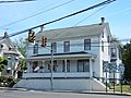
Main St. (Route 113).
-
Historic home. Was the post office.
-
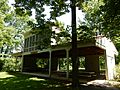
W. Albert Reese Park in Silverdale.


See also
 In Spanish: Silverdale (Pensilvania) para niños
