Warren County, New Jersey facts for kids
Quick facts for kids
Warren County
|
|||
|---|---|---|---|
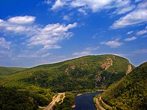
Delaware Water Gap (center) between Warren County (right) and neighboring Monroe County, Pennsylvania (left) in May 2008
|
|||
|
|||
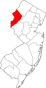
Location within the U.S. state of New Jersey
|
|||
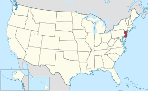 New Jersey's location within the U.S. |
|||
| Country | |||
| State | |||
| Founded | November 20, 1824 | ||
| Named for | Joseph Warren | ||
| Seat | Belvidere | ||
| Largest municipality | Phillipsburg (population) Hardwick Township (area) |
||
| Area | |||
| • Total | 362.65 sq mi (939.3 km2) | ||
| • Land | 356.54 sq mi (923.4 km2) | ||
| • Water | 6.11 sq mi (15.8 km2) 1.7% | ||
| Population
(2020)
|
|||
| • Total | 109,632 | ||
| • Estimate
(2023)
|
111,252 |
||
| • Density | 302.308/sq mi (116.7218/km2) | ||
| Time zone | UTC−5 (Eastern) | ||
| • Summer (DST) | UTC−4 (EDT) | ||
| Congressional district | 7th | ||
Warren County is a county in the state of New Jersey. It is located in the northern part of the state. In 2020, about 109,632 people lived here. This was the highest number of people ever counted in the county. It was a small increase of 0.9% from 2010.
The county is next to the Delaware River and Easton, Pennsylvania. It is also close to the New York City area. To its northwest are the Pocono Mountains. Hunterdon County is to its south.
Warren County is part of the Allentown-Bethlehem-Easton, PA-NJ metropolitan area. It is the only New Jersey county not linked to New York City or Philadelphia. The biggest town by population is Phillipsburg, with over 15,000 residents. Hardwick Township is the largest by area, but has the fewest people. The main town for the county government is Belvidere.
Warren County became an official county on November 20, 1824. It was formed from parts of Sussex County. The county is named after Joseph Warren. He was an important leader during the American Revolution. He died fighting in the Battle of Bunker Hill in 1775.
| Top - 0-9 A B C D E F G H I J K L M N O P Q R S T U V W X Y Z |
History of Warren County
How Warren County Got Its Name
Warren County is named after Joseph Warren. He was a doctor and a brave leader during the American Revolutionary War. He died fighting as a soldier at the Battle of Bunker Hill.
Native American Life
Around 1000 B.C., people in this area started using clay pottery. This was the start of the Woodland period. Pottery helped them store and cook food better.
Different groups of Native Americans lived here. The Algonquian-speaking Lenape people moved into the area around 1000 A.D. They came from the Mississippi River area.
Around 500 A.D., new tools appeared, like the bow and arrow. This made hunting easier because hunters could be further away from animals. They could get more food. Nuts could be stored in clay pots, which were also used for cooking.
Farming also began around this time. People started growing corn, beans, and squash. They likely got seeds from other traveling groups. Families began to settle down more because they could store food and hunt better. Farming helped more people live in these areas. The Lenape tended their gardens in spring and summer. They fished in shallow rivers and trapped animals.
Early European Settlement (17th Century)
In the early 1600s, the weather became colder during a time called the Little Ice Age. Late and early frosts made it hard to grow crops like corn, beans, and squash. Cold weather also made hunting difficult. Nut crops sometimes failed, making food scarce. Rivers froze, stopping fishing.
Europeans also brought new diseases. Native Americans had never been exposed to these diseases. Many Native Americans became sick and died. This, along with food shortages from the cold weather, caused their population to drop a lot. As the Native American population decreased, more land became available for European settlers.
The Dutch settled the Hudson River Valley. They claimed all the land west of the Hudson River. Later, the British took over. New Jersey was divided into two parts: East Jersey and West Jersey. In the 1600s, the area of Warren County was part of Burlington County.
Becoming a County (18th and 19th Centuries)
The area that is now Warren County changed hands several times. In 1714, it became part of Hunterdon County. Then, in 1739, it was included in Morris County. Finally, in 1753, Sussex County (which included present-day Warren County) separated from Morris County.
During the French and Indian War (1754-1763), small forts were built along the Delaware River. These forts stretched from Phillipsburg to Port Jervis, New York. The mountains of Warren County were on the edge of the war zone. Native American tribes, like the Lenape, Shawnee, and Iroquois, sometimes raided settlements in Sussex County.
In 1756, a group of Lenape raided homes and took some settlers during the Hunt-Swartout raid. Because of these attacks, the governor of New Jersey ordered eight forts to be built along the Delaware River. These forts protected the New Jersey frontier. Some were just small blockhouses, while others were fortified homes.
By the early 1800s, towns like Phillipsburg, Hackettstown, Belvidere, and Washington grew into important communities. In 1824, Warren County was officially created. Belvidere was chosen as its main town, called the county seat.
Geography and Climate
Warren County covers about 362.65 square miles. Most of this (98.3%) is land, and a small part (1.7%) is water. The county has rolling hills. The Kittatinny Ridge is in the west. Allamuchy Mountain and Jenny Jump Mountain are also here. These mountains formed millions of years ago when land masses collided.
About 21,000 to 13,000 years ago, a large glacier covered the northern part of the county. This glacier shaped the land. When it melted, a lake formed at Great Meadows. Over time, the lake drained, leaving a flat area with rich soil.
Three main rivers flow through the county. They are shallow and narrow, great for fishing.
- The Paulins Kill flows through the western part of the county. It empties into the Delaware River.
- The Pequest River flows through the middle of the county. It also empties into the Delaware River at Belvidere.
- The Musconetcong River starts at Lake Musconetcong. It forms the border between Warren County and Morris and Hunterdon counties. It drains the southern part of the county and flows into the Delaware River.
Warren County is located in two valleys. The Kittatinny Valley is in the northern part. The Lehigh Valley borders the southern part.
The highest point in the county is about 1,600 feet above sea level on the Kittatinny Ridge. The lowest point is where the Delaware and Musconetcong rivers meet, at 160 feet above sea level.
Climate and Weather
Warren County has a humid continental climate. This means it has warm summers and cold winters. In Phillipsburg, average temperatures range from 29.0°F in January to 74.2°F in July. In Hackettstown, they range from 27.0°F in January to 71.5°F in July.
In Belvidere, the county seat, temperatures average from 19°F in January to 85°F in July. The lowest temperature ever recorded was -17°F in January 1994. The highest was 101°F in July 1999. The county gets a good amount of rain, ranging from 2.77 inches in February to 4.65 inches in July.
| Weather chart for Belvidere, New Jersey | |||||||||||||||||||||||||||||||||||||||||||||||
|---|---|---|---|---|---|---|---|---|---|---|---|---|---|---|---|---|---|---|---|---|---|---|---|---|---|---|---|---|---|---|---|---|---|---|---|---|---|---|---|---|---|---|---|---|---|---|---|
| J | F | M | A | M | J | J | A | S | O | N | D | ||||||||||||||||||||||||||||||||||||
|
3.1
37
19
|
2.8
41
21
|
3.6
50
28
|
4
61
37
|
4.1
72
47
|
4.3
80
57
|
4.7
85
62
|
3.9
83
60
|
4.3
76
52
|
4.5
65
41
|
3.6
54
32
|
3.6
42
24
|
||||||||||||||||||||||||||||||||||||
| temperatures in °F precipitation totals in inches source: The Weather Channel |
|||||||||||||||||||||||||||||||||||||||||||||||
|
Metric conversion
|
|||||||||||||||||||||||||||||||||||||||||||||||
Population Information
| Historical population | |||
|---|---|---|---|
| Census | Pop. | %± | |
| 1830 | 18,627 | — | |
| 1840 | 20,366 | 9.3% | |
| 1850 | 22,358 | 9.8% | |
| 1860 | 28,433 | 27.2% | |
| 1870 | 34,336 | 20.8% | |
| 1880 | 36,589 | 6.6% | |
| 1890 | 36,553 | −0.1% | |
| 1900 | 37,781 | 3.4% | |
| 1910 | 43,187 | 14.3% | |
| 1920 | 45,057 | 4.3% | |
| 1930 | 49,319 | 9.5% | |
| 1940 | 50,181 | 1.7% | |
| 1950 | 54,374 | 8.4% | |
| 1960 | 63,220 | 16.3% | |
| 1970 | 73,960 | 17.0% | |
| 1980 | 84,429 | 14.2% | |
| 1990 | 91,607 | 8.5% | |
| 2000 | 102,437 | 11.8% | |
| 2010 | 108,692 | 6.1% | |
| 2020 | 109,632 | 0.9% | |
| 2023 (est.) | 111,252 | 2.4% | |
| Historical sources: 1790–1990 1970–2010 2000 2010 2000–2010 2010-2020 |
|||
In 2010, Warren County had 108,692 people living in 41,480 homes. About 28,870 of these were families. The county had about 304.5 people per square mile.
Most people (90.29%) were White. About 3.51% were Black or African American. About 2.46% were Asian. People of Hispanic or Latino background made up 7.05% of the population.
About 23.6% of the people were under 18 years old. The average age was 41.5 years.
Towns and Communities
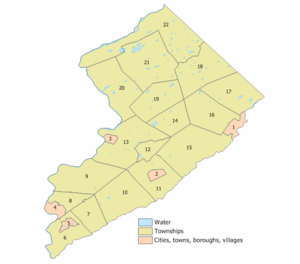
Warren County has 22 towns and townships. Here is a list of them:
| Municipality (with map key) |
Map key | Mun. type |
Pop. | Housing units |
Total area |
Water area |
Land Area |
Pop. density |
Housing density |
School district | Communities |
|---|---|---|---|---|---|---|---|---|---|---|---|
| Allamuchy Township |
17 | township | 5,335 | 2,096 | 20.76 | 0.31 | 20.45 | 211.3 | 102.5 | Hackettstown (9–12) (S/R) Allamuchy (PK-8) |
Allamuchy CDP (156) Panther Valley CDP (4,391) |
| Alpha | 5 | borough | 2,328 | 1,032 | 1.70 | 0.03 | 1.67 | 1,417.2 | 617.4 | Phillipsburg (9–12) (S/R) Alpha (PK-8) |
|
| Belvidere | 3 | town | 2,520 | 1,140 | 1.49 | 0.04 | 1.45 | 1,847.0 | 785.4 | Belvidere | |
| Blairstown Township |
21 | township | 5,704 | 2,272 | 31.70 | 0.89 | 30.82 | 193.6 | 73.7 | North Warren (7–12) Blairstown (K-6) |
Blairstown CDP (493) Hainesburg CDP (part; 422) Paulina |
| Franklin Township |
10 | township | 2,968 | 1,219 | 24.13 | 0.09 | 24.04 | 132.1 | 50.7 | Warren Hills (7–12) Franklin Township (PK-6) |
Asbury CDP (270) Broadway CDP (213) New Village CDP (399) |
| Frelinghuysen Township |
18 | township | 2,199 | 826 | 23.57 | 0.24 | 23.32 | 95.6 | 35.4 | North Warren (7–12) Frelinghuysen (PK-6) |
Johnsonburg CDP (381) Marksboro CDP (186) |
| Greenwich Township |
7 | township | 5,473 | 1,870 | 10.54 | 0.01 | 10.53 | 542.5 | 177.6 | Phillipsburg (9–12) (S/R) Greenwich (PK-8) |
Greenwich CDP (2,558) Stewartsville CDP (636) Upper Stewartsville CDP (329) |
| Hackettstown | 1 | town | 10,248 | 3,755 | 3.71 | 0.10 | 3.61 | 2,696.1 | 1,041.1 | Hackettstown | |
| Hardwick Township |
22 | township | 1,598 | 619 | 37.92 | 1.32 | 36.60 | 46.3 | 16.9 | North Warren (7–12) Blairstown (K-6) |
|
| Harmony Township |
9 | township | 2,503 | 1,109 | 24.08 | 0.38 | 23.70 | 112.5 | 46.8 | Belvidere (9–12) (S/R) Harmony (PK-8) |
Brainards CDP (194) Harmony CDP (374) Hutchinson CDP (103) |
| Hope Township |
19 | township | 1,835 | 809 | 18.84 | 0.22 | 18.62 | 104.8 | 43.4 | Belvidere (9–12) (S/R) Hope Township (PK-8) |
Hope CDP (256) Mount Hermon CDP (172) Silver Lake CDP (368) |
| Independence Township |
16 | township | 5,469 | 2,325 | 19.89 | 0.15 | 19.74 | 286.8 | 117.8 | Hackettstown (9–12) (S/R) Great Meadows (K-8) |
Great Meadows CDP (305) Vienna CDP (881) |
| Knowlton Township |
20 | township | 2,894 | 1,212 | 25.33 | 0.58 | 24.75 | 123.4 | 49.0 | North Warren (7–12) Knowlton (PK-6) |
Columbia CDP (215) Delaware CDP (173) Hainesburg CDP (part; 422) Warrington |
| Liberty | 14 | township | 2,670 | 1,151 | 11.87 | 0.26 | 11.60 | 253.6 | 99.2 | Hackettstown (9–12) (S/R) Great Meadows (K-8) |
Mountain Lake CDP (494) Townsbury |
| Lopatcong | 8 | township | 8,776 | 3,420 | 7.16 | 0.06 | 7.10 | 1,129.0 | 481.8 | Phillipsburg (9–12) (S/R) Lopatcong (PK-8) |
Delaware Park CDP (739) Lopatcong Overlook CDP (692) |
| Mansfield Township |
15 | township | 7,781 | 3,316 | 29.93 | 0.11 | 29.82 | 259.1 | 111.2 | Warren Hills (7–12) Mansfield (PK-6) |
Anderson CDP (306) Beattystown CDP (4,701) Port Murray CDP (227) |
| Oxford Township |
12 | township | 2,444 | 1,033 | 5.89 | 0.10 | 5.79 | 434.5 | 178.5 | Warren Hills (9–12) (S/R) Oxford (K-8) |
Oxford CDP (1,033) |
| Phillipsburg | 4 | town | 15,249 | 6,607 | 3.31 | 0.12 | 3.19 | 4,682.1 | 2,069.2 | Phillipsburg | |
| Pohatcong | 6 | township | 3,241 | 1,420 | 13.71 | 0.36 | 13.36 | 250.0 | 106.3 | Phillipsburg (9–12) (S/R) Pohatcong (PK-8) |
Carpentersville Finesville CDP (364) Hughesville Upper Pohatcong CDP (1,714) |
| Washington Borough |
2 | borough | 7,299 | 2,897 | 1.95 | 0.00 | 1.94 | 3,326.8 | 1,491.7 | Warren Hills (7–12) Washington Borough (PK-6) |
|
| Washington Township |
11 | township | 6,492 | 2,493 | 17.75 | 0.09 | 17.66 | 376.6 | 141.1 | Warren Hills (7–12) Washington Township (PK-6) |
Brass Castle CDP (1,536) Changewater Port Colden CDP (260) |
| White | 13 | township | 4,606 | 2,304 | 27.63 | 0.48 | 27.15 | 179.8 | 84.9 | Belvidere (9–12) (S/R) White Township (PK-8) |
Bridgeville CDP (229) Brookfield CDP (727) Buttzville CDP (205) Foul Rift (ghost town) |
| Warren County | county | 109,632 | 44,925 | 362.86 | 5.94 | 356.92 | 304.5 | 125.9 |
Past Communities
- Pahaquarry Township (existed from 1854 to 1997)
Getting Around Warren County
Roads and Highways
In 2010, Warren County had over 1,000 miles of roads. Local towns maintained most of them. The county and the state also took care of many miles of roads.
Important state and federal roads include:
- Route 31: Runs north-south from Buttzville to Trenton.
- Route 57: Connects Lopatcong Township to Hackettstown.
- U.S. Route 22: Passes through the Phillipsburg area.
- U.S. Route 46: Runs from Columbia to Hackettstown.
- Interstate 78: Known as the Phillipsburg-Newark Expressway.
- Interstate 80: Known as the Bergen-Passaic Expressway.
Air Travel
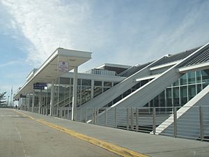
For air travel, people in Warren County use Lehigh Valley International Airport in Allentown, Pennsylvania. Newark Liberty International Airport in Newark, New Jersey, is also to the east of the county.
Bus and Train Services
Warren County has bus services provided by Easton Coach. These buses offer routes along Route 31 and Route 57. NJ Transit also runs buses in the Phillipsburg area.
For trains, Warren County has one NJ Transit stop. It is at the Hackettstown station. This station is on the Montclair-Boonton Line and the Morristown Line.
Freight trains also use the Lehigh Line. This line runs through southern Warren County to Phillipsburg.
Education in Warren County
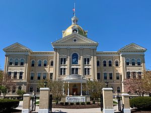
Colleges and Universities
- Centenary University: A private college in Hackettstown.
- Warren County Community College: Located in Washington Township. It offers associate degrees and certificate programs. It also partners with four-year colleges for bachelor's degrees. About 1,700 students attend here.
Private Schools
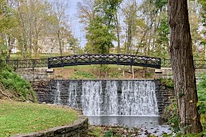
- Blair Academy: A private school in Blairstown. It helps students prepare for college. It was started in 1848.
Public School Districts
Warren County has several school districts:
- Schools for all grades (K-12)
- Belvidere School District
- Hackettstown School District
- Phillipsburg School District
- Warren County Special Services School District
- High School Districts (7-12 or 9-12)
- North Warren Regional High School (grades 7–12)
- Warren County Vocational School District (grades 9–12)
- Warren Hills Regional School District (grades 7–12)
- Elementary School Districts (K-8 or K-6)
- Alpha School District (K–8)
- Allamuchy Township School District (K–8)
- Blairstown Township School District (K–6)
- Franklin Township School District (Warren County, New Jersey) (K–6)
- Frelinghuysen Township School District (K–6)
- Great Meadows Regional School District (K–8)
- Greenwich Township School District (K–8)
- Harmony Township School District (K–8)
- Hope Township School District (K–8)
- Knowlton Township School District (K–6)
- Lopatcong Township School District (K–8)
- Mansfield Township School District (K–6)
- Oxford Township School District (K–8)
- Pohatcong Township School District (K–8)
- Washington Borough Public Schools (K–6)
- Washington Township School District (K–6)
- White Township School District (K–8)
Public High Schools
- Belvidere High School: Students from Harmony, Hope, and White townships attend here.
- Hackettstown High School: Students from Allamuchy, Independence, and Liberty townships attend here.
- North Warren Regional High School: Serves students from Blairstown, Frelinghuysen, Hardwick, and Knowlton townships.
- Phillipsburg High School: Students from Alpha Borough and Greenwich, Lopatcong, and Pohatcong townships attend here.
- Warren County Technical School: Serves the whole county for grades 9–12. It also has a night school for adults.
- Warren Hills Regional High School: Serves students from Washington Borough and Washington, Mansfield, Franklin, and Oxford townships.
Parks and Outdoor Fun
Warren County is a great place for outdoor activities. Much of the county is part of the Warren Hills Viticultural Area, which means it's good for growing grapes. There are five active wineries here:
The county is next to the Delaware Water Gap National Recreation Area. This area is perfect for hiking and enjoying nature. Warren County also has many places for hunting and fishing.
The New Jersey Division of Fish and Wildlife has its Pequest Fish Hatchery in Warren County. This hatchery raises thousands of trout and other fish. It's also a learning center for outdoor activities.
You can find wildlife management areas like White Lake, Oxford Lake, and the Pequest River W.M.A. The five main rivers and creeks for fishing are the Paulinskill, the Pequest, the Musconetcong, Pohatcong Creek, and the Delaware River. Merrill Creek Reservoir also has fish and game nearby.
|
See also
 In Spanish: Condado de Warren (Nueva Jersey) para niños
 | Victor J. Glover |
 | Yvonne Cagle |
 | Jeanette Epps |
 | Bernard A. Harris Jr. |


