
Port Murray, New Jersey facts for kids
Quick facts for kids
Port Murray, New Jersey
|
|
|---|---|

Historic buildings on Main Street
|
|

United States Census Bureau map of ZCTA 07865 Port Murray, New Jersey
|
|

Port Murray, New Jersey
Location in Warren County, New Jersey

Port Murray, New Jersey
Location in New Jersey

Port Murray, New Jersey
Location in the United States
|
|
| Country | |
| State | |
| County | Warren |
| Township | Mansfield |
| Named for | James Boyles Murray |
| Area | |
| • Total | 0.99 sq mi (2.56 km2) |
| • Land | 0.99 sq mi (2.56 km2) |
| • Water | 0.00 sq mi (0.00 km2) 0.57% |
| Elevation | 633 ft (193 m) |
| Population
(2020)
|
|
| • Total | 227 |
| • Density | 229.52/sq mi (88.65/km2) |
| Time zone | UTC−05:00 (Eastern (EST)) |
| • Summer (DST) | UTC−04:00 (EDT) |
| ZIP Code |
07865
|
| Area code(s) | 908 |
| FIPS code | 34-60450 |
| GNIS feature ID | 02584020 |
Port Murray is a small community in New Jersey, USA. It is located in Mansfield Township within Warren County. This area is known as an "unincorporated community," meaning it's a place with a shared identity but without its own local government. It's also a "census-designated place" (CDP), which means the United States Census Bureau defines it for counting people.
The community got its name because of its location on the Morris Canal. It was named after Colonel James Boyles Murray, who was the third president of the Morris Canal and Banking Company. The local post office uses the ZIP Code 07865.
Contents
Exploring Port Murray's Location and Size
Port Murray is a small area. The United States Census Bureau measured its total area. It covers about 0.168 square miles (0.435 square kilometers). Almost all of this area is land, with only a tiny bit of water.
Understanding Port Murray's Population
| Historical population | |||
|---|---|---|---|
| Census | Pop. | %± | |
| 2010 | 129 | — | |
| 2020 | 227 | 76.0% | |
| U.S. Decennial Census 2010 2020 |
|||
The population of Port Murray has changed over time. In 2010, the census counted 129 people living there. By 2020, the population had grown to 227 people.
How Many People Live in Port Murray?
In 2010, there were 129 people living in Port Murray. These people lived in 57 households, with 39 of those being families. The community had 63 housing units.
The population included people of different ages:
- 14.7% were under 18 years old.
- 7.0% were between 18 and 24 years old.
- 23.3% were between 25 and 44 years old.
- 35.7% were between 45 and 64 years old.
- 19.4% were 65 years or older.
The average age of people in Port Murray was about 48.1 years.
Transportation in Port Murray
Port Murray once had its own train station. This station was part of the Morris and Essex Railroad. It was located about 67 miles west of New York City. This made it easier for people to travel to and from the community.
Port Murray's Historic District
A special part of Port Murray is called the Port Murray Historic District. This district was added to the National Register of Historic Places on June 7, 1996. This means the buildings and area have important historical value and are protected.
Notable People from Port Murray
Some interesting people have connections to Port Murray.
- John Eugene Kunzler (1923–2006) was a scientist and physicist. He did important early research on superconducting magnets. These magnets are used in many modern technologies, like MRI machines.
Images for kids
-
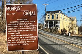
Canal Store on the Morris Canal
-
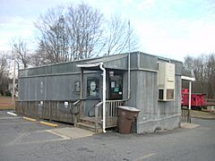
Post office consisting of a one-story trailer
-
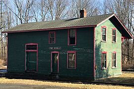
Former station on the Morris and Essex Railroad
-
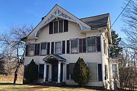
Port Murray Historic District
Carpenter Gothic architecture


See also
 In Spanish: Port Murray para niños
