Lopatcong Township, New Jersey facts for kids
Quick facts for kids
Lopatcong Township, New Jersey
|
||
|---|---|---|
|
Township
|
||
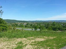
Lopatcong Township seen from the base of Marble Mountain
|
||
|
||
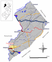
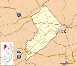
Location of Lopatcong Township in Warren County highlighted in yellow (right). Inset map: Location of Warren County in New Jersey highlighted in black (left).
|
||
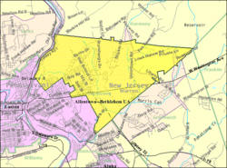
Census Bureau map of Lopatcong Township, New Jersey
|
||
| Country | ||
| State | ||
| County | ||
| Incorporated | March 7, 1851 | |
| Government | ||
| • Type | Faulkner Act (small municipality) | |
| • Body | Township Council | |
| Area | ||
| • Total | 7.38 sq mi (19.10 km2) | |
| • Land | 7.32 sq mi (18.95 km2) | |
| • Water | 0.06 sq mi (0.16 km2) 0.81% | |
| Area rank | 237th of 565 in state 16th of 22 in county |
|
| Elevation | 384 ft (117 m) | |
| Population
(2020)
|
||
| • Total | 8,776 | |
| • Estimate
(2023)
|
9,431 | |
| • Rank | 274th of 565 in state 3rd of 22 in county |
|
| • Density | 1,199.6/sq mi (463.2/km2) | |
| • Density rank | 362nd of 565 in state 6th of 22 in county |
|
| Time zone | UTC−05:00 (Eastern (EST)) | |
| • Summer (DST) | UTC−04:00 (Eastern (EDT)) | |
| ZIP Code |
08865
|
|
| Area code(s) | 908 | |
| FIPS code | 3404141490 | |
| GNIS feature ID | 0882252 | |
| School district | Phillipsburg School District | |
| Website | ||
Lopatcong Township is a community located in Warren County, New Jersey, in the United States. It's known as a township, which is a type of local government in New Jersey. In 2020, about 8,776 people lived here. This was a good increase from 2010, showing the township is growing!
Contents
History of Lopatcong Township
Lopatcong Township has an interesting past. It was first created on March 7, 1851. Back then, it was called Phillipsburg Township. This happened because the New Jersey Legislature decided to take parts of two other townships, Greenwich and Harmony, to form this new area.
A few years later, in 1861, the town of Phillipsburg became its own separate place. So, on March 18, 1863, the township changed its name to Lopatcong. This new name came from the Lopatcong Creek that flows through the area.
The name "Lopatcong" has a special meaning. It comes from the Lenape Native Americans. Their words "Lowan peek achtu onk" mean "winter watering place for deer". This tells us a bit about what the area was like long ago!
Geography of Lopatcong Township
Lopatcong Township covers an area of about 7.38 square miles (19.10 square kilometers). Most of this is land, with a small part being water.
Within the township, you'll find smaller communities. These include Delaware Park and Lopatcong Overlook. These are places where people live, but they are not separate towns.
Lopatcong Township shares its borders with several other communities in Warren County. These include Greenwich Township, Harmony Township, Phillipsburg, and Pohatcong Township.
The township is also close to bigger cities. It's about 21.8 miles (35.1 km) northeast of Allentown. It's also about 70.6 miles (113.6 km) west of New York City.
Population Growth in Lopatcong Township
Lopatcong Township has seen its population grow quite a bit over the years. Here's a look at how many people have lived there at different times:
| Historical population | |||
|---|---|---|---|
| Census | Pop. | %± | |
| 1860 | 3,741 | — | |
| 1870 | 1,150 | * | −69.3% |
| 1880 | 1,591 | 38.3% | |
| 1890 | 1,738 | 9.2% | |
| 1900 | 1,982 | 14.0% | |
| 1910 | 766 | −61.4% | |
| 1920 | 1,050 | 37.1% | |
| 1930 | 1,269 | 20.9% | |
| 1940 | 1,450 | 14.3% | |
| 1950 | 1,737 | 19.8% | |
| 1960 | 2,703 | 55.6% | |
| 1970 | 3,144 | 16.3% | |
| 1980 | 4,998 | 59.0% | |
| 1990 | 5,052 | 1.1% | |
| 2000 | 5,765 | 14.1% | |
| 2010 | 8,014 | 39.0% | |
| 2020 | 8,776 | 9.5% | |
| 2023 (est.) | 9,431 | 17.7% | |
| Population sources: 1860–1920 1860–1870 1880–1890 1890–1910 1910–1930 1940–2000 2000 2010 2020 * = Lost territory in previous decade |
|||
In 2010, there were 8,014 people living in Lopatcong Township. The population density was about 1,129 people per square mile. This means a lot of people live in a relatively small area! The average household had about 2.46 people.
Education in Lopatcong Township
Education is important in Lopatcong Township. The Lopatcong Township School District serves students from pre-kindergarten all the way through eighth grade. The district has two schools:
- Lopatcong Elementary School: This school teaches students from Pre-K to 4th grade.
- Lopatcong Middle School: This school is for students in 5th through 8th grade. It opened in 2003 because more students were joining the district.
After 8th grade, students go to Phillipsburg High School. This high school is located in Phillipsburg, New Jersey. Students from Lopatcong Township attend Phillipsburg High School as part of a special agreement with the Phillipsburg School District.
The new Phillipsburg High School building was actually built within Lopatcong Township's borders! It's a large, modern building that opened for students in the 2016–17 school year. It can hold over 2,100 students.
Students in Warren County also have other school options. They can attend the Ridge and Valley Charter School for grades K–8. For high school, they might go to Warren County Technical School in Washington borough.
Transportation in Lopatcong Township
Getting around Lopatcong Township is easy with its network of roads.
Major Roads and Highways
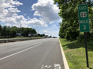
The most important highway in Lopatcong Township is US 22. This road runs through the southern part of the township. Another key road is Route 57, which starts at US 22 and goes towards the center of the township. County Route 519 also passes through the eastern side of the township.
Public Transportation Options
For public transportation, NJ Transit offers bus services. You can catch buses on the 890 and 891 routes to travel around the area.
Notable People from Lopatcong Township
Many interesting people have lived in or are connected to Lopatcong Township. Here are a few:
- Donald J. Albanese (born 1937): A politician who served in the New Jersey General Assembly.
- Ned Bolcar (born 1967): A professional football player who played as a linebacker in the NFL.
- Lou Reda (1925–2017): A filmmaker known for creating television documentaries.
- Harold S. Sloan (1888–1988): An economist who taught and wrote about economics.
- Doug Steinhardt (born 1968): An attorney and politician who served as mayor of Lopatcong Township.
Lopatcong Township in Film
Lopatcong Township was the main filming location for an independent film called Several Ways to Die Trying. The writer and director of the film, Glen Tickle, along with some of the cast and crew, actually live in the township!
See also
 In Spanish: Municipio de Lopatcong para niños
 | Audre Lorde |
 | John Berry Meachum |
 | Ferdinand Lee Barnett |


