
Delaware Water Gap facts for kids
Quick facts for kids Delaware Water Gap |
|
|---|---|

The Delaware Water Gap from the Appalachian Trail at Mount Minsi in Pennsylvania, with I-80 on the left.
|
|
| Elevation | 335 ft (102 m) |
| Traversed by | |
| Location | New Jersey and Pennsylvania, U.S. |
| Range | Blue Mountains/Kittatinny Ridge |
| Coordinates | 40°58′3.7″N 75°7′11.6″W / 40.967694°N 75.119889°W |
| Topo map | Portland, Stroudsburg |
The Delaware Water Gap is a special place where the Delaware River cuts right through a big mountain ridge. It sits on the border between New Jersey and Pennsylvania. This amazing natural feature is part of the Appalachian Mountains.
This gap is the southern part of the Delaware Water Gap National Recreation Area. People love to visit for fun activities like canoeing, fishing, hiking, and rock climbing. The U.S. National Park Service looks after this area. Some parts are also watched over by the New Jersey Division of Parks and Forestry.
You don't need to pay an entrance fee to get into the park. However, there are small fees for things like parking passes, using bicycles, or going to the beaches. Most of the park is open all day and night. Day-use areas, like parking lots and picnic spots, are open from sunrise to sunset.
Contents
How Did the Delaware Water Gap Form?


A water gap is a cool geological feature where a river cuts through a mountain. The Delaware Water Gap started forming about 500 million years ago. Back then, tiny quartz pebbles from ancient mountains settled in a shallow sea.
Later, about 450 million years ago, volcanic islands crashed into North America. This pushed up the land, forming the Highlands and Kittatinny Valley. About 400 million years ago, a small continent also collided with North America. This huge pressure heated the rocks, making them bend and crack over thousands of years.
The Delaware River slowly carved its way through these cracked rocks. If the rocks hadn't been cracked, the river couldn't have made its path through the mountain. Over millions of years, rain, ice, snow, and wind shaped the area. The last big ice age, called the Wisconsin glaciation, covered the whole Kittatinny Ridge. When the glaciers melted, the gap looked much like it does today.
The mountain here is made of tough gray rock called shawangunk conglomerate. This rock is very strong and doesn't wear away easily. The gap is about 1,300 feet (400 m) wide at the river level. From the top of one mountain to the other, it's about 1 mile (1.6 km) wide. The river flows more than 1,200 feet (366 m) below the mountaintops.
The mountain ridge the Delaware River crosses is called the Blue Mountains in Pennsylvania. In New Jersey, it's known as the Kittatinny Ridge. This is the first big ridge of the Appalachian Mountains. The New Jersey mountain is Mount Tammany, named after Lenni-Lenape Chief Tamanend. The Pennsylvania mountain is Mount Minsi, named after the Native American tribe from the area. Mount Tammany's top is 1,540 feet (469 m) above sea level.
Plants and Animals of the Gap

In 1739, John Bartram, America's first botanist, explored the Delaware River. He was looking for new trees and plants to send back to England. He rode on horseback through the Water Gap, using Native American trails. This allowed him to discover new species.
The slopes of the Delaware Water Gap are covered by a northern deciduous forest. You can find many kinds of oaks, hickories, maples, ash, and birch trees. There are also Eastern White Pine and Eastern Hemlock trees.
Many animals live in this forest. You might see black bears, white-tailed deer, gray squirrels, raccoons, and chipmunks. Hunting is allowed for deer, turkey, and small animals, following state rules. However, hunting is not permitted at campsites.
Fish like shad, bass, trout, and carp swim in the river. Dunnfield Creek is special because it has natural brook trout.
Be careful of Timber rattlesnakes and copperheads in the rocky areas. Salamanders live in the moist parts of the forest. You can even find Eastern prickly pear cactus growing on Mount Minsi.
Getting Around the Delaware Water Gap

For a long time, it was hard to travel through the gap because of the steep rock walls. A road was finally built on the Pennsylvania side in 1793. In 1830, another road was built on the New Jersey side.
Today, Interstate 80 goes through the gap on the New Jersey side. It uses the Delaware Water Gap Toll Bridge. This highway follows the path of an old railway line.
Trains still run through the gap on the Pennsylvania side. The Pennsylvania Northeast Regional Railroad Authority owns the tracks. The Delaware-Lackawanna Railroad operates trains on these lines. Pennsylvania Route 611 also goes through the gap, following an old trolley line.
You can also get to the Delaware Water Gap by bus. Martz Trailways has a bus station in the town of Delaware Water Gap. There are also smaller buses that stop there on their way to cities like New York City, Hazleton, and Scranton.
Delaware Water Gap National Recreation Area
In 1962, the U.S. Congress planned to build a dam across the Delaware River. This dam was meant to control flooding. However, it was never built. The land bought for the dam's reservoir was instead used to create the Delaware Water Gap National Recreation Area in 1965.
There are two visitor centers for the park. One is in New Jersey, near the Delaware River bridge. The other is in Dingman's Ferry, Pennsylvania. The park's main office is on River Road in Pennsylvania. The New Jersey side of the gap is also protected as part of Worthington State Forest.
Hiking Trails to Explore
The Delaware Water Gap has many great trails for hiking. Here are some popular ones:
| Trail | Length (one-way) | Elevation Change | Difficulty | Blaze |
|---|---|---|---|---|
| Mt. Tammany | 1.2 miles (1.9 km) | 1,201 feet (366 m) | Difficult | Red |
| Pahaquarry | 1.7 miles (2.7 km) | 1,201 feet (366 m) | Difficult | Blue |
| Dunnfield Creek | 3.5 miles (5.6 km) | 966 feet (294 m) | Moderate | Green |
Mount Tammany Trail
This trail leads up 1,200 feet (366 m) to the top of Mount Tammany. From the summit, you can see amazing views of Mount Minsi in Pennsylvania.
Pahaquarry Trail
This is another trail to the top of Mount Tammany. For a challenging hike, you can combine the Red Dot and Blue Blaze trails into a 3-mile (4.8 km) loop. Park rangers suggest going up the Red Dot trail and coming down the Blue Blaze trail, as the Blue trail is less steep.
Dunnfield Creek Trail
The Dunnfield Creek Trail starts near the Appalachian Trail. It follows the creek for most of its length, crossing it many times. The trail then climbs up a ravine to meet the Appalachian Trail again at Sunfish Pond.
Appalachian Trail
The famous Appalachian Trail runs from Georgia to Maine. It enters the Delaware Water Gap at the Delaware River bridge. It then goes to Sunfish Pond and continues northeast. About 28 miles (45 km) of the 2,174-mile (3,500 km) trail are within the Delaware Water Gap National Recreation Area.
Rock Climbing Adventures
The Delaware Water Gap is a popular spot for rock climbing in New Jersey. The climbs are usually 150 to 300 feet (46 to 91 m) tall. Most climbing happens on the New Jersey side because it's easier to get to. There are about one hundred different climbs there. Climbs are rated from 5.1 (easy) to 5.14 (very hard) on the Yosemite Decimal System scale.
Sometimes, the Pennsylvania side of the gap is closed for climbing. This happens during the nesting season for peregrine falcons, which are an endangered species. This helps protect these special birds.
Boy Scout Camps in the Area
Several Boy Scout camps used to be located near the Delaware Water Gap. The Easton Area Council of the Boy Scouts of America ran Weygadt Scout Reservation from 1931 to 1968. This reservation had two camps: Camp Weygadt and Minsi Trails Council's Camp Minsi. Later, Camp Minsi moved to a new location.
Pahaquarra Boy Scout Camp was on the New Jersey side, near an old copper mine. Just north of it was Camp Cowaw Boy Scout Camp. These camps offered outdoor adventures for Boy Scouts.
Images for kids
-
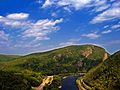
The Delaware Water Gap from the Appalachian Trail at Mount Minsi in Pennsylvania, with I-80 on the left.
-
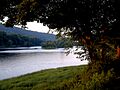
Worthington State Forest seen from a campsite.
-
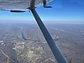
The Delaware Water Gap with the Pennsylvania town of the same name visible in the lower left next to the I-80 crossing.
-
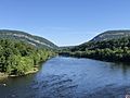
The Delaware Water Gap seen from the Delaware River Viaduct in Knowlton Township, New Jersey in June 2021.
-
The Delaware Water Gap as seen from Knowlton Township, New Jersey in Warren County.
