Delaware Water Gap, Pennsylvania facts for kids
Quick facts for kids
Delaware Water Gap, Pennsylvania
|
|
|---|---|
|
Borough
|
|

Delaware Water Gap, Pennsylvania
|
|

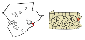
Location of Delaware Water Gap in Monroe County, Pennsylvania.
|
|
| Country | |
| State | |
| County | Monroe |
| Area | |
| • Total | 2.06 sq mi (5.35 km2) |
| • Land | 1.93 sq mi (5.00 km2) |
| • Water | 0.13 sq mi (0.35 km2) |
| Elevation | 400 ft (100 m) |
| Population
(2020)
|
|
| • Total | 675 |
| • Density | 349.74/sq mi (135.02/km2) |
| Time zone | UTC-5 (EST) |
| • Summer (DST) | UTC-4 (EDT) |
| ZIP Code |
18327
|
| Area code(s) | 570 |
| FIPS code | 42-18736 |
| Website | dwgpa.gov |
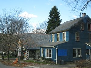
Delaware Water Gap is a small town, called a borough, in Monroe County, Pennsylvania, United States. It's right next to the famous Delaware Water Gap, which is a natural pass through mountains. This pass is where major roads like Interstate 80 and train lines cross the Pennsylvania-New Jersey border along the Delaware River.
In 2020, about 675 people lived in Delaware Water Gap.
Contents
History of Delaware Water Gap
The old Delaware Water Gap station (Delaware, Lackawanna and Western Railroad) is an important historical building. It was added to the National Register of Historic Places in 2002, meaning it's a special place worth protecting.
Geography of Delaware Water Gap
Delaware Water Gap is located at 40°58′55″N 75°8′33″W / 40.98194°N 75.14250°W.
The United States Census Bureau says the borough covers about 1.7 square miles (4.4 square kilometers) of land. There is no water area within the borough limits.
Population of Delaware Water Gap
| Historical population | |||
|---|---|---|---|
| Census | Pop. | %± | |
| 1880 | 201 | — | |
| 1890 | 467 | 132.3% | |
| 1900 | 469 | 0.4% | |
| 1910 | 446 | −4.9% | |
| 1920 | 373 | −16.4% | |
| 1930 | 443 | 18.8% | |
| 1940 | 410 | −7.4% | |
| 1950 | 734 | 79.0% | |
| 1960 | 554 | −24.5% | |
| 1970 | 533 | −3.8% | |
| 1980 | 597 | 12.0% | |
| 1990 | 733 | 22.8% | |
| 2000 | 744 | 1.5% | |
| 2010 | 746 | 0.3% | |
| 2020 | 675 | −9.5% | |
| 2021 (est.) | 682 | −8.6% | |
| Sources:2020 | |||
In 2010, there were 746 people living in the borough. Most residents were White (81.4%), with smaller groups of Black (6.3%), Asian (3.9%), and Native American (0.1%) people. About 7.2% of the population was Hispanic or Latino.
In 2000, the population was 744 people. The average household had about 2 people, and the average family had about 2.7 people.
The population was spread out by age:
- 19% were under 18 years old.
- 10.1% were between 18 and 24.
- 36.2% were between 25 and 44.
- 24.2% were between 45 and 64.
- 10.6% were 65 years or older.
The average age in the borough was 36 years.
Schools in Delaware Water Gap
The students in Delaware Water Gap attend schools in the Stroudsburg Area School District.
Getting Around Delaware Water Gap
As of 2018, Delaware Water Gap had about 7.5 miles (12.1 kilometers) of public roads. Some roads are kept up by the state, and others by the borough itself.
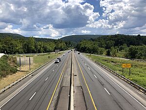
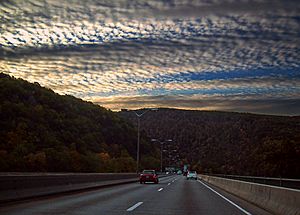
Interstate 80 is the main highway that goes through Delaware Water Gap. It runs from northwest to southeast and crosses the Delaware River into New Jersey over the Delaware Water Gap Toll Bridge. Pennsylvania Route 611 also goes through the town.
The famous Appalachian Trail hiking path also passes through Delaware Water Gap before continuing into New Jersey.
Events in Delaware Water Gap
- Every September, Delaware Water Gap hosts the Celebration of the Arts Festival. This festival features amazing jazz musicians, sculptors, and painters from the area.
Climate in Delaware Water Gap
Delaware Water Gap has a climate with hot summers and cold winters. It gets rain all year round. Even though summer days can feel a bit sticky, sometimes it gets very hot and humid. The hottest temperature ever recorded since 1981 was 100.0°F (37.8°C) on July 22, 2011.
July is usually the warmest month and also has the most thunderstorms. September is often the wettest month, sometimes due to leftover storms from the Atlantic hurricane season. The most rain in one day since 1981 was 6.39 inches (162 mm) on October 8, 2005.
In winter, the coldest temperature ever recorded since 1981 was -18.3°F (-27.9°C) on January 21, 1994. It can get very cold and windy, with wind chill making it feel much colder. January is usually the coldest month and gets the most snow. Big snowstorms with 12 inches (30 cm) or more of snow happen every few years, especially from December to February.
| Climate data for Delaware Water Gap, Elevation 387 ft (118 m), 1981-2010 normals, extremes 1981-2018 | |||||||||||||
|---|---|---|---|---|---|---|---|---|---|---|---|---|---|
| Month | Jan | Feb | Mar | Apr | May | Jun | Jul | Aug | Sep | Oct | Nov | Dec | Year |
| Record high °F (°C) | 68.2 (20.1) |
76.5 (24.7) |
85.7 (29.8) |
93.9 (34.4) |
94.2 (34.6) |
94.8 (34.9) |
100.0 (37.8) |
98.3 (36.8) |
96.0 (35.6) |
87.7 (30.9) |
78.9 (26.1) |
70.8 (21.6) |
100.0 (37.8) |
| Mean daily maximum °F (°C) | 36.7 (2.6) |
40.4 (4.7) |
49.3 (9.6) |
62.2 (16.8) |
72.4 (22.4) |
80.4 (26.9) |
84.5 (29.2) |
82.8 (28.2) |
75.6 (24.2) |
64.2 (17.9) |
52.9 (11.6) |
41.0 (5.0) |
62.0 (16.7) |
| Daily mean °F (°C) | 27.6 (−2.4) |
30.5 (−0.8) |
38.4 (3.6) |
49.8 (9.9) |
59.8 (15.4) |
68.5 (20.3) |
73.0 (22.8) |
71.4 (21.9) |
64.0 (17.8) |
52.5 (11.4) |
42.7 (5.9) |
32.5 (0.3) |
51.0 (10.6) |
| Mean daily minimum °F (°C) | 18.5 (−7.5) |
20.6 (−6.3) |
27.6 (−2.4) |
37.3 (2.9) |
47.1 (8.4) |
56.6 (13.7) |
61.5 (16.4) |
60.0 (15.6) |
52.3 (11.3) |
40.7 (4.8) |
32.6 (0.3) |
23.9 (−4.5) |
40.0 (4.4) |
| Record low °F (°C) | −18.3 (−27.9) |
−8.9 (−22.7) |
−0.8 (−18.2) |
14.0 (−10.0) |
27.4 (−2.6) |
36.3 (2.4) |
42.4 (5.8) |
37.8 (3.2) |
29.9 (−1.2) |
19.6 (−6.9) |
5.5 (−14.7) |
−7.3 (−21.8) |
−18.3 (−27.9) |
| Average precipitation inches (mm) | 3.40 (86) |
2.97 (75) |
3.65 (93) |
4.12 (105) |
4.43 (113) |
4.48 (114) |
4.52 (115) |
4.41 (112) |
4.94 (125) |
4.75 (121) |
4.00 (102) |
4.07 (103) |
49.74 (1,263) |
| Average snowfall inches (cm) | 13.4 (34) |
9.6 (24) |
10.0 (25) |
2.4 (6.1) |
0.0 (0.0) |
0.0 (0.0) |
0.0 (0.0) |
0.0 (0.0) |
0.0 (0.0) |
0.1 (0.25) |
2.5 (6.4) |
8.1 (21) |
46.2 (117) |
| Average relative humidity (%) | 68.5 | 63.8 | 59.5 | 57.3 | 61.9 | 68.9 | 68.7 | 71.7 | 72.5 | 70.5 | 69.4 | 69.7 | 66.9 |
| Average dew point °F (°C) | 18.6 (−7.4) |
19.7 (−6.8) |
25.5 (−3.6) |
35.3 (1.8) |
46.7 (8.2) |
57.9 (14.4) |
62.1 (16.7) |
61.8 (16.6) |
55.0 (12.8) |
43.2 (6.2) |
33.4 (0.8) |
23.7 (−4.6) |
40.3 (4.6) |
| Source: PRISM | |||||||||||||
Nature and Plants
The natural plants around Delaware Water Gap are mostly Oak trees and other Hardwood trees, forming an Eastern Hardwood Forest. The spring flowers usually bloom in late April, and the leaves change color in mid-October. The area's coldest winter temperature averages around -4.3°F (-20.2°C), which helps certain plants grow well here.
See also
 In Spanish: Delaware Water Gap (Pensilvania) para niños
 | Kyle Baker |
 | Joseph Yoakum |
 | Laura Wheeler Waring |
 | Henry Ossawa Tanner |


