Pequest River facts for kids
Quick facts for kids Pequest River |
|
|---|---|

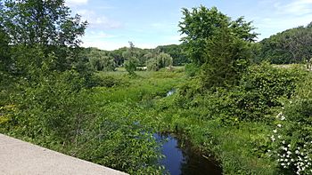
Headwaters of the Pequest near Springdale, in Andover Township, New Jersey
|
|
| Country | United States of America |
| Physical characteristics | |
| Main source | Stickles Pond, Newton, New Jersey 668 feet (204 m) 41°01′50″N 74°45′12″W / 41.03056°N 74.75333°W |
| River mouth | Delaware River at Belvidere, New Jersey 40°49′44″N 75°04′59″W / 40.82889°N 75.08306°W |
| Length | 35.7 miles (57.5 km) |
| Basin features | |
| Basin size | 162.62 square miles (421.2 km2) |
The Pequest River is a 35.7-mile (57.5 km) long river in northwestern New Jersey, United States. It is a tributary of the larger Delaware River. The Pequest River flows through a beautiful area known as the Skylands Region.
The name "Pequest" comes from Native American words. It means "open land." The river drains a large area of about 162.62 square miles (421.2 square kilometers). This area includes parts of Sussex and Warren counties. Ten different towns are located within this river's drainage area.
Contents
Journey of the Pequest River
The Pequest River begins its journey at Stickles Pond in Newton. This is in Sussex County. From there, it flows south through small towns like Springdale and Huntsville. After about 3.5 miles (5.6 km), the river starts to turn towards the southwest.
The river then flows through Tranquility. It runs along the northwestern side of the Allamuchy Mountain ridge. Near Allamuchy, it meets another stream called Trout Brook.
Through the Great Meadows
Next, the Pequest River joins Bear Creek in an area called Bear Swamp. It then passes through a unique, reclaimed swampy area. This area is known as the Great Meadows. It lies between two mountain ridges: Jenny Jump Mountain and Cat Swamp Mountain.
A road called Shades Of Death Road runs along Jenny Jump Mountain here. Some of the land in the Great Meadows was drained long ago. This was done by digging and clearing parts of the Pequest River and its smaller streams. This helped make the land good for farming.
Towards the Delaware River
The river leaves the Great Meadows by looping through a gap. This gap is between Cat Swamp Mountain and Danville Mountain. It then continues along the southeastern side of Mount Mohepinoke. Here, it enters the Pequest Wildlife Management Area.
Furnace Brook flows into the Pequest as it goes down into a small gorge. This gorge is cut between Mt. Mohepinoke and a part of the Scotts Mountain area. The Pequest then turns west. Mountain Lake Brook joins the river just before Buttzville. This is where the river leaves the Pequest Wildlife Management Area.
The Pequest River continues west through Bridgeville. It turns slightly north and meets Beaver Brook. After this, it turns southwest again. Finally, the river tumbles down to Belvidere in a series of small waterfalls. Here, it flows into the mighty Delaware River.
Pequest River's Helper Streams
The Pequest River has several smaller streams that flow into it. These are called tributaries. They help carry water to the main river.
- Beaver Brook
- Mountain Lake Brook
- Furnace Brook
- Bear Creek
- Trout Brook
 | Victor J. Glover |
 | Yvonne Cagle |
 | Jeanette Epps |
 | Bernard A. Harris Jr. |

