Kittatinny Valley facts for kids
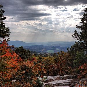
The Kittatinny Valley is a beautiful area in northwestern New Jersey. It stretches across Sussex and Warren counties. To its west, you'll find Kittatinny Mountain, and to its east, the Highlands region.
This valley is about 39 miles (63 km) long. It is also about 10 miles (16 km) wide in the middle of Sussex and Warren Counties.
Contents
Geology and Geography of the Valley
The Kittatinny Valley is located in the northern part of New Jersey. On its western side, it starts near the New York state line, close to High Point. It then goes southwest along the base of Kittatinny Mountain. This side ends near Columbia on the New Jersey-Pennsylvania border. This spot is just south of the Delaware Water Gap.
The eastern side of the valley runs northeast along the Jenny Jump Mountains. It then follows the base of the Allamuchy Mountains to Andover. From there, it goes along the western edge of the Pimple Hills to the Hamburg Mountains. The valley's eastern edge then follows the western base of Hamburg Mountain up to the New York State line.
North of New York, you'll find the Hudson Valley. South of the valley is the Lehigh Valley. The Hudson, Lehigh, and Kittatinny Valleys are all parts of the much larger Great Appalachian Valley.
How the Valley Was Formed
Long, long ago, the land that is now the Kittatinny Valley was covered by a deep sea. About 450 million years ago, a chain of volcanoes crashed into what would become North America. This huge crash pushed and squeezed the rocks that were at the bottom of the sea. This is how the Kittatinny Valley was formed.
Later, around 400 million years ago, another large landmass bumped into North America. This caused the land to fold and crack. These movements created the Kittatinny Mountain and other mountains in the southern Appalachians. The valley sits between two types of rock: the Silurian Shawangunk quartz conglomerate and the lower Cambrian Hardyston quartzite.
The Shawangunk conglomerate rock sits on top of the Martinsburg formation. This happened because quartz pebbles were moved onto the Martinsburg shale. Then, huge geological pressure folded and faulted these rocks, creating Kittatinny Mountain. About half of the valley is made of the Martinsburg formation, which is shale and slate. Other parts of the valley are made of Kittatinny and Jacksonburg limestones. Most of these rock layers run in belts from northeast to southwest.
The Impact of Glaciers
Around 21,000 BC to 13,000 BC, a giant sheet of ice called the Wisconsin Glacier covered the valley. This ice was about 300 meters (980 ft) thick! When the glacier melted, it left behind piles of rock and dirt called end moraines. It also created long, winding ridges and new lakes.
Some of the lakes formed by the melting glacier include Culver's Lake, Lake Aeroflex, Cranberry Lake, and Lake Owassa. Lake Aeroflex is the deepest, reaching 110 feet (34 m) deep.
Rivers of the Valley
Three small rivers drain the Kittatinny Valley:
- The Paulinskill River starts near Newton. It flows north to Augusta, then southeast to join the Delaware River near Columbia.
- The Wallkill River begins at Lake Mohawk in Sparta. It flows northwest. Smaller streams like Papakating Creek join it north of Sussex. The Wallkill then flows north into New York State and eventually into the Hudson River.
- The Pequest River starts in Andover Township. It flows south to Great Meadows, then east to Belvidere, where it also drains into the Delaware River.
All three of these rivers are great places for trout fishing. They are stocked with fish every year.
History of the Kittatinny Valley
Early People: Paleo Indians and Native Americans
After the Wisconsin Glacier melted around 13,000 BC, the first people arrived in the Kittatinny Valley. These Paleo Indians came around 10,500 BC. They hunted animals, fished in the streams, and gathered plants. The valley's flat land and fresh water made it easy for them to find food.
Later, Native Americans settled here. They set up camps along the shallow rivers. These rivers were perfect for fishing and hunting waterfowl. The nearby forests provided plenty of small and large game.
European Settlement
Europeans began to settle in the Kittatinny Valley in the early 1740s. They cut down the thick forests to create farms and sell timber. By the early 1900s, almost all the original forest was gone. Settlers built stone walls to mark their property lines. You can still see these old rock walls all over the valley today.
Most of the first houses were made of wood, so they often burned down or rotted away. A few houses made of local stone still exist.
Farming in the Valley
The Europeans saw that parts of the valley were flat and good for farming. They cleared the land, removing rocks and using them to build the boundary walls. Today, low-lying fields are used to grow grass for cows and horses. Other fields grow corn for animals. Some farms also grow pumpkins or tomatoes. You can also find apple and peach orchards. There are many dairy farms with 20 to 75 cows.
Protected Areas
The Kittatinny Valley and Kittatinny Mountain have many protected areas. These places help keep the natural beauty and wildlife safe. They include:
- High Point State Park (15,826 acres)
- Stokes State Forest (16,066 acres)
- Worthington State Forest (6,584 acres)
- Jenny Jump State Forest (4,288 acres)
- 12 state wildlife management areas (about 19,000 total acres)
- Delaware Water Gap National Recreation Area, New Jersey part (31,000 acres)
- Wallkill River National Wildlife Refuge (5,100 acres)
- Swartswood State Park (2,472 acres)
- Wild and Scenic River designation for the Delaware River (about 35 miles)
- Many natural areas and preserves managed by groups like The Nature Conservancy and Ridge and Valley Conservancy
 | Calvin Brent |
 | Walter T. Bailey |
 | Martha Cassell Thompson |
 | Alberta Jeannette Cassell |


