
Cranberry Lake facts for kids
Quick facts for kids Cranberry Lake |
|
|---|---|

Black Duck Hole, Cranberry Lake
|
|

Cranberry Lake
Location in New York Adirondack Park

Cranberry Lake
Location in the United States
|
|
| Location | St. Lawrence County, New York, US |
| Coordinates | 44°07′32″N 74°53′07″W / 44.1254270°N 74.8852263°W, 44°10′22″N 74°49′31″W / 44.1727737°N 74.8252705°W, 44°07′06″N 74°53′24″W / 44.1182651°N 74.8901374°W |
| Type | Reservoir |
| Primary inflows | Oswegatchie River (east branch) |
| Primary outflows | Oswegatchie River (east branch) |
| Basin countries | United States |
| Max. length | 8.6 mi (13.8 km) |
| Max. width | 3.8 mi (6.1 km) |
| Surface area | 6,975 acres (2,823 ha) |
| Average depth | 6 ft (1.8 m) |
| Max. depth | 38 ft (12 m) |
| Shore length1 | 55 mi (89 km) |
| Surface elevation | 1,480 ft (450 m) |
| Islands | 38 Joe Indian Island, Buck Island |
| Settlements | Cranberry Lake, Wanakena |
| 1 Shore length is not a well-defined measure. | |
Cranberry Lake is a large lake in the Adirondack Park in New York State, United States. It's the third biggest lake in the Adirondacks. It sits on the east branch of the Oswegatchie River. Most of the land around the lake, about 75%, belongs to New York State. The Five Ponds Wilderness Area is next to its south shore. The Cranberry Lake Wild Forest covers much of the rest of the shoreline.
Contents
Where is Cranberry Lake?
Most of Cranberry Lake is in the eastern part of the Town of Clifton. A small section is in the Town of Piercefield. Another small part is in the Town of Fine. The entire lake is located in the southern part of Saint Lawrence County, New York.
The community of Cranberry Lake is on a northern arm of the lake. On a western arm, you'll find Wanakena. This town is home to the SUNY-ESF Ranger School.
The lake has many islands. The biggest ones are Joe Indian Island and Buck Island. The Cranberry Lake Biological Station is also located on Barber Point. This station is part of SUNY-ESF.
Fun Things to Do at the Lake
Cranberry Lake is a great spot for outdoor adventures. A piece of land sticking into the lake from the north has Bear Mountain. You can find state camping areas there.
Hiking Bear Mountain
The Bear Mountain Trail starts near campsite loop 3. Another starting point with good parking is closer to the campground entrance. The hike is a bit tough, but it's only about 1-mile (1.6 km) to the top. From the lookout spot, you get an amazing view. You can see Joe Indian and Buck islands from there.
Interesting Spots Around the Lake
Many private camps are found on the lake's southern shore. One island is called "Chair Rock Island." On Barber Point, near the Biological Station, there's a rock with a special engraving. It remembers Reuben Wood, a famous fly casting champion from the 1800s. He designed special fishing flies.
There was once a large place called Wildcliffe Lodge. It used to be an inn, bar, and restaurant. The dining room was once the log cabin of Philo Scott, a hermit. He married a local woman and had eight children. Chair Rock Lodge was another popular spot for dining and lodging. Both of these places are now closed.
The Indian Mountain Club was also on the South Shore. People from downstate New York would visit. They enjoyed dining, lodging, and outdoor activities. These included hunting, fishing, and shooting. A large garden provided fresh vegetables for the club.
Places to Explore on the Lake
- Arnold's Point – A point located near Joe Indian Island.
- Barber Island – An island located off Barber Point.
- Black Duck Hole – A bay located off the Dead Creek Flow bay.
- Brandy Brook Flow – A bay on the northeast part of the lake. Brandy Brook enters here.
- Bear Mountain Flow – A bay located north of Brandy Brook Flow bay.
- Birch Island – An island located off Union Point.
- Buck Island – An island located off Coles Point in the South Bay.
- Barber Point – A point located by the inlet of Sucker Brook.
- Dead Creek Flow – A bay where the Dead Creek enters the lake.
- Elephant Rock – An island located off Arnold's Point.
- Eagle Island – An island located off the Bear Mountain peninsula.
- Flatiron Point – A point at the mouth of the Oswegatchie River Inlet Flow.
- Joe Indian Island – The largest island on the lake, off Shanty Brook Flow.
- Matilda Bay – A bay located west of Matilda Island.
- Matilda Island – An island located near the lake's outlet.
- Oswegatchie River Inlet Flow – A bay where the Oswegatchie River and Skate Creek enter.
- South Flow – A bay south of Buck Island. The Six Mile Creek enters here.
Fishing in Cranberry Lake
Cranberry Lake is a great place for fishing. You can find many types of fish here. These include smallmouth bass, northern pike, and brook trout. Other fish like rock bass, yellow perch, and brown bullhead also live in the lake. You might also catch sunfish and brown trout.
There are several places to launch a boat. One is a state-owned ramp on Route 3 by the outlet dam. Another is a state-owned car-top launch at the Cranberry Lake Campground. There's also a launch at the New York State Rangers School in Wanakena, New York.
History of the Lake
The lake got its name from the many cranberry bogs that used to be there. In 1865, a dam was built on the Oswegatchie River's east branch. This dam doubled the lake's size. It also caused many trees to die, and you can still see their stumps in some areas.
In 1902, the Rich Brothers Lumber Company bought land near the lake. They built a large lumber mill. Homes for the workers were made from wood from another old lumber operation. At its busiest, the mill had up to 1500 workers.
A special logging railroad was built in 1905. It connected Wanakena to another railroad. This made it easier for tourists to visit the area. In 1913, another railroad was built by the Emporium Lumber Company. It connected Cranberry Lake to the New York Central Railroad.
The Rich Bros. Lumber Co. gave 1,800 acres (7.3 km2) of land to the New York State Ranger School in 1912. Later, in 1923, a businessman named Charles Lathrop Pack donated 1,000 acres (4.0 km2) of land. This land is now the Cranberry Lake Biological Station. In 1929, the International Paper Company also donated 500 acres (2.0 km2) to the Ranger School. By 1940, the state had bought most of the remaining land from the old lumber companies.
Images for kids
-
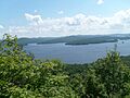
View from Bear Mountain lookout over Cranberry Lake

