
Andover, New Jersey facts for kids
Quick facts for kids
Andover, New Jersey
|
|
|---|---|
|
Borough
|
|

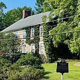
Grist Mill Stone House, built 1760
|
|

Map of Andover Borough in Sussex County. Inset: Location of Sussex County in New Jersey.
|
|

Census Bureau map of Andover, New Jersey.
|
|

Andover, New Jersey
Location in Sussex County, New Jersey

Andover, New Jersey
Location in New Jersey

Andover, New Jersey
Location in the United States
|
|
| Country | |
| State | |
| County | |
| Incorporated | March 25, 1904 |
| Named for | Andover, Hampshire, England |
| Government | |
| • Type | Borough |
| • Body | Borough Council |
| Area | |
| • Total | 1.36 sq mi (3.53 km2) |
| • Land | 1.35 sq mi (3.49 km2) |
| • Water | 0.02 sq mi (0.04 km2) 1.18% |
| Area rank | 464th of 565 in state 21st of 24 in county |
| Elevation | 646 ft (197 m) |
| Population
(2020)
|
|
| • Total | 595 |
| • Estimate
(2023)
|
603 |
| • Rank | 549th of 565 in state 23rd of 24 in county |
| • Density | 441.4/sq mi (170.4/km2) |
| • Density rank | 449th of 565 in state 10th of 24 in county |
| Time zone | UTC−05:00 (Eastern (EST)) |
| • Summer (DST) | UTC−04:00 (Eastern (EDT)) |
| ZIP Code |
07821
|
| Area codes | 973 exchange: 786 |
| FIPS code | 3403701330 |
| GNIS feature ID | 885140 |
| Website | |
Andover is a small town, called a borough, located in Sussex County, in the state of New Jersey. In 2020, about 595 people lived there. This number was a little less than in 2010.
Andover became an official borough on March 25, 1904. It was created from parts of Andover Township. The town gets its name from Andover Township, which was named after a place called Andover, Hampshire in England.
Contents
Where is Andover Located?
Andover is a small area, covering about 1.36 square miles (3.53 square kilometers). Most of this area is land. Only a tiny part is water.
The borough shares its borders with a few other towns in Sussex County. These include Andover Township, Byram Township, and Green Township.
What is Andover's Weather Like?
Andover experiences all four seasons. Summers are usually warm, and winters are cold. The area gets a fair amount of rain throughout the year.
How Many People Live in Andover?
| Historical population | |||
|---|---|---|---|
| Census | Pop. | %± | |
| 1910 | 884 | — | |
| 1920 | 417 | −52.8% | |
| 1930 | 479 | 14.9% | |
| 1940 | 512 | 6.9% | |
| 1950 | 560 | 9.4% | |
| 1960 | 734 | 31.1% | |
| 1970 | 813 | 10.8% | |
| 1980 | 892 | 9.7% | |
| 1990 | 700 | −21.5% | |
| 2000 | 658 | −6.0% | |
| 2010 | 606 | −7.9% | |
| 2020 | 595 | −1.8% | |
| 2023 (est.) | 603 | −0.5% | |
| Population sources: 1910–1920 1910 1910–1930 1940–2000 2000 2010 2020 |
|||
Andover's Population in 2010
In 2010, there were 606 people living in Andover. Most residents were White. There were also people from Black, Native American, and Asian backgrounds. About 7.6% of the population identified as Hispanic or Latino.
The average household had about 2.5 people. About 21% of the people living in Andover were under 18 years old. The median age was around 40 years old.
Schools in Andover
Local Public Schools
Younger students in Andover, from pre-kindergarten to eighth grade, go to schools in the Andover Regional School District. Students from Andover Township also attend these schools.
The district has two schools:
- Florence M. Burd Elementary School (PreK-4)
- Long Pond Middle School (grades 5-8)
A school board with nine members helps run the district. Andover Borough has one seat on this board.
High School Education
Students in grades nine through twelve attend Newton High School. This high school is located in Newton. Students from Andover Township and Green Township also go to Newton High School.
Specialized School
Since 1972, Lakeland Andover School has been open. It's a private school for students in grades 7-12. This school helps students who have emotional and behavioral challenges. It also provides job training.
Getting Around Andover

Major Roads
Andover has several roads that help people travel. U.S. Route 206 and County Route 517 both pass through the borough.
Buses and Trains
Lakeland Bus Lines offers bus service from Newton, New Jersey, to Midtown Manhattan in New York City. These buses travel along Interstate 80.
There are plans to bring back train service through the Lackawanna Cut-Off Restoration Project. This project aims to rebuild a part of the old railroad. A new train station is planned for Andover Township. This train service is expected to open around 2026.
Airports Nearby
There are two small airports close to Andover:
- Aeroflex-Andover Airport is about 2 miles north of the town center.
- Trinca Airport is about 3 miles southwest.
Cool Places to See in Andover
Andover has several historic spots. Many of these places are listed on the New Jersey Register of Historic Places.
- The Grist Mill Stone House was built in 1760. It's part of a historic area that includes the old Andover Iron Forge and Furnace.
- There's also a beautiful old house on Brighton Avenue.
- The Hole in the Wall Stone Arch Bridge was built by the Sussex Railroad. It crosses the Morris and Sussex Turnpike. Today, this bridge is part of the Sussex Branch Trail, which is a path for walking and biking.
-
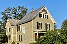
Brighton Avenue House
-
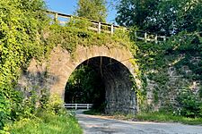
Hole in the Wall Stone Arch Bridge
-
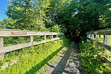
Sussex Branch Trail


The Iron Master's Mansion on Main Street was also part of the historic Iron Works in Andover.
-
Iron Master's Mansion

Famous People From Andover
Here are some people who have lived in or are connected to Andover:
- Stephen M. Balzer (1864–1940): A mechanic who helped create an early car and airplane engine.
- Kenneth Burke (1897–1993): A well-known writer and philosopher. He was the grandfather of famous musicians Harry and Tom Chapin.
- Finn M. W. Caspersen (1941–2009): A successful financier and someone who gave a lot to charity.
- Newman E. Drake (1860–1930): The person who started the famous Drake's baking company.
- Rob Freeman (born 1981): A member of the band Hidden in Plain View.
See also
 In Spanish: Andover (Nueva Jersey) para niños
