
Finesville, New Jersey facts for kids
Quick facts for kids
Finesville, New Jersey
|
|
|---|---|

Stone houses on Mount Joy Road
|
|

Finesville, New Jersey
Location in Warren County, New Jersey

Finesville, New Jersey
Location in New Jersey

Finesville, New Jersey
Location in the United States
|
|
| Country | |
| State | |
| County | Warren |
| Township | Pohatcong |
| Named for | Philip and John Fein |
| Area | |
| • Total | 2.19 sq mi (5.68 km2) |
| • Land | 2.12 sq mi (5.48 km2) |
| • Water | 0.08 sq mi (0.20 km2) 0.00% |
| Elevation | 262 ft (80 m) |
| Population
(2020)
|
|
| • Total | 364 |
| • Density | 171.94/sq mi (66.39/km2) |
| Time zone | UTC−05:00 (Eastern (EST)) |
| • Summer (DST) | UTC−04:00 (EDT) |
| Area code(s) | 908 |
| FIPS code | 34-23340 |
| GNIS feature ID | 876338 2583989 |
Finesville is a small, historic community in New Jersey. It's located in Pohatcong Township, within Warren County. About 364 people lived here in 2020. Finesville is known for its beautiful old stone houses and its rich history. It sits near the Musconetcong River, a lovely spot for nature lovers.
Contents
History of Finesville

Finesville was named after Philip and John Fein. They were brothers from Germany who settled here. They built a dam and several mills, like an oil mill and a gristmill. They also ran a hotel and a store. This helped the community grow.
One of the first big buildings was Chelsea Forge, built in 1751. This forge made iron using charcoal. It was very important during the American Revolutionary War. It even helped make weapons for the Continental Army at Valley Forge.
Later, the Fein gristmill burned down. It was rebuilt and became a paper mill. Then it changed into a knife factory. Before 1800, the Shank Brothers ran a ferry across the Delaware River nearby.
Finesville Dam History
The first Finesville Dam was built around 1751. It was used for an iron forge. The last dam was made of concrete in 1952. This old dam was removed in 2011. This helped fish like shad swim upstream to lay their eggs. It also made the river habitat better.
Finesville Historic District
|
Finesville–Seigletown Historic District
|
|

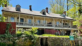
Finesville Hotel on County Route 627
|
|
| Location | County Route 627; Mountain, Musconetcong, Mount Joy and Bellis Roads |
|---|---|
| Area | 195 acres (79 ha) |
| Architectural style | Early Republic, Late Victorian, multiple styles |
| NRHP reference No. | 10000892 |
| Significant dates | |
| Added to NRHP | November 10, 2010 |
The Finesville–Seigletown Historic District is a special area. It covers 195 acres. This district is important for its history, buildings, and engineering. It was added to the National Register of Historic Places in 2010.
The district includes 97 important buildings. It also has 6 structures and 5 sites. Many of the buildings are old stone houses. You can see different styles of architecture here. These include Colonial Revival, Gothic Revival, and Victorian styles.
-
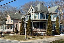
Queen Anne and Colonial Revival houses on County Route 627
-
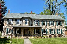
Stone house on Mount Joy Road in Holland Township
-
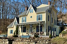
Stone house with Victorian embellishment
-
House with Gothic Revival influences


Geography of Finesville
Finesville is located along the Musconetcong River. It sits between two mountains: Pohatcong Mountain and Musconetcong Mountain. The community is about one mile east of the Delaware River. It's part of a beautiful area called the Musconetcong Gorge.
The total area of Finesville is about 0.325 square miles (0.841 km2). All of this area is land.
Community Buildings
Finesville has a few important community buildings. The Finesville Church was built in 1877. The Finesville United Methodist Church was built in 1879. This church shows Greek Revival architecture influences. Both churches are part of the historic district.
-
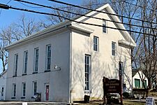
Finesville Church
-
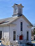
Finesville United Methodist Church


Transportation in Finesville

The Mount Joy Road Bridge crosses the Musconetcong River. It connects Pohatcong and Holland Townships. This bridge was built around 1890. It is a special type of bridge called a Pratt truss bridge. It's the only one known to be made by G. M. Russling.
County Route 627 runs through Finesville. This road connects with Mountain Road and Mount Joy Road.
Points of Interest
- Hunts Meadow – This area is named after Edward Hunt. He was a patriot who helped the Continental Army. In 1778, he dug a millrace here. He also kept 60 cavalry horses for the army during the winter.
- Seigletown – This part of the community is named for Benjamin Seigle. He was a captain in the Revolutionary militia. He lived here and made red clay pottery. His family also owned a farm, mills, a blacksmith shop, and a hematite mine.
See also
 In Spanish: Finesville para niños
