
Stewartsville, New Jersey facts for kids
Quick facts for kids
Stewartsville, New Jersey
|
|
|---|---|

Hulshizer/Brill farm on North main street built in 1833
|
|

Stewartsville, New Jersey
Location in Warren County, New Jersey

Stewartsville, New Jersey
Location in New Jersey

Stewartsville, New Jersey
Location in the United States
|
|
| Country | |
| State | |
| County | Warren |
| Township | Greenwich |
| Named for | Thomas Stewart |
| Area | |
| • Total | 1.08 sq mi (2.80 km2) |
| • Land | 1.08 sq mi (2.80 km2) |
| • Water | 0.00 sq mi (0.00 km2) 0.00% |
| Elevation | 315 ft (96 m) |
| Population
(2020)
|
|
| • Total | 636 |
| • Density | 587.80/sq mi (226.98/km2) |
| Time zone | UTC−05:00 (Eastern (EST)) |
| • Summer (DST) | UTC−04:00 (EDT) |
| ZIP Code |
08886
|
| Area code(s) | 908 |
| FIPS code | 34-70800 |
| GNIS feature ID | 2584031 |
Stewartsville is a small community in Greenwich Township, Warren County, New Jersey. It is known as a census-designated place (CDP), which means it's an area identified by the government for collecting population data. In 2010, about 349 people lived here. By 2020, the population grew to 636 people.
The community gets its name from Thomas Stewart. He was a secretary to George Washington, a very important person in American history. Thomas Stewart bought land in this area back in 1793. The local post office uses ZIP Code 08886 for Stewartsville.
Contents
Stewartsville's Location and Size
Stewartsville is a small place. According to the United States Census Bureau, the CDP covers an area of about 0.129 square miles (0.333 square kilometers). All of this area is land, with no water bodies like lakes or rivers within its official boundaries.
Who Lives in Stewartsville?
| Historical population | |||
|---|---|---|---|
| Census | Pop. | %± | |
| 2020 | 636 | — | |
| U.S. Decennial Census | |||
The population of Stewartsville has grown over the years. In 2010, there were 349 people living in the CDP. By 2020, the number of residents increased to 636.
Looking at the 2010 Census Data
In 2010, there were 134 households in Stewartsville. A household is a group of people living together in one home. Most households (52.2%) were married couples. About 14.2% of homes had a female head of the household without a husband present.
The average household had about 2.60 people. The average family had about 3.05 people. The median age of people living in Stewartsville in 2010 was 40.3 years old. This means half the people were younger than 40.3 and half were older.
Getting Around Stewartsville
You can easily reach Stewartsville by car using Interstate 78. There are two exits, Exit 3 and Exit 4, that lead to the area.
In the past, Stewartsville also had a train station. It was part of the Morris and Essex Railroad and was about 80 miles from New York City.
Places to Visit in Stewartsville
There are a few interesting spots near Stewartsville.
Historic Kennedy House and Mill
The Kennedy House and Mill is a historic site located nearby on Route 173 in Kennedy Mills. This old building was added to the National Register of Historic Places in 1996. It's a great example of history in the area.
Local Churches
Stewartsville has two churches that are important parts of the community. These are the First Lutheran Church and the Stewartsville Presbyterian Church.
-
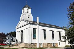
First Lutheran Church
-
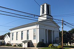
Stewartsville Presbyterian Church


Famous People from Stewartsville
Some well-known people have connections to Stewartsville:
- Orange Cassidy (born 1984), a professional wrestler.
- Justin Gaymon (born 1986), a former athlete who competed in the 400-meter hurdles.
See also
 In Spanish: Stewartsville (Nueva Jersey) para niños
