Hardwick Township, New Jersey facts for kids
Quick facts for kids
Hardwick Township, New Jersey
|
|
|---|---|
|
Township
|
|
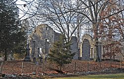
Spring Valley Christian Church Site in Hardwick Township, July 2007
|
|
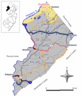
Location of Hardwick Township in Warren County highlighted in yellow (right). Inset map: Location of Warren County in New Jersey highlighted in black (left).
|
|
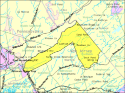
Census Bureau map of Hardwick Township, New Jersey
|
|
| Country | |
| State | |
| County | |
| Royal charter | January 22, 1750 |
| Incorporated | February 21, 1798 |
| Named for | Philip Yorke, 1st Earl of Hardwicke |
| Government | |
| • Type | Township |
| • Body | Township Committee |
| Area | |
| • Total | 38.94 sq mi (100.85 km2) |
| • Land | 37.53 sq mi (97.19 km2) |
| • Water | 1.42 sq mi (3.66 km2) 3.63% |
| Area rank | 58th of 565 in state 1st of 22 in county |
| Elevation | 827 ft (252 m) |
| Population
(2020)
|
|
| • Total | 1,598 |
| • Estimate
(2023)
|
1,610 |
| • Rank | 507th of 565 in state 22nd of 22 in county |
| • Density | 42.6/sq mi (16.4/km2) |
| • Density rank | 556th of 565 in state 22nd of 22 in county |
| Time zone | UTC−05:00 (Eastern (EST)) |
| • Summer (DST) | UTC−04:00 (Eastern (EDT)) |
| ZIP Code |
07825 – Blairstown, New Jersey
|
| Area code(s) | 908 exchange: 841 |
| FIPS code | 3404129820 |
| GNIS feature ID | 0882239 |
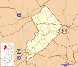
Hardwick Township is a small community located in Warren County, in the U.S. state of New Jersey. It's called a "township" because of how its local government is set up. In 2020, about 1,598 people lived here. This number was a little lower than in 2010.
Contents
History of Hardwick Township
Hardwick Township was first created a very long time ago, around 1713, by a special permission from the king, called a "royal patent." It officially became a township on January 22, 1750, through a "royal charter." At that time, it was part of Morris County.
Later, in 1753, it became part of the new Sussex County. Over the years, parts of Hardwick Township were used to form other townships, like Independence Township in 1782 and Frelinghuysen Township in 1848.
In 1798, the New Jersey Legislature (the state's law-making body) officially made Hardwick Township an "incorporated" township. This means it became a legal town with its own government. In 1824, most of Hardwick Township became part of the newly formed Warren County. The township was named after Philip Yorke, 1st Earl of Hardwicke, an important person from England.
How Hardwick's Shape Changed
Hardwick Township has an unusual shape on the map. This is because it took in Pahaquarry Township in 1997, which was a nearby area that no longer had its own government. Pahaquarry Township was created in 1825. Its name came from a Native American word, Pahaqualong, used by the Lenape people. It meant "termination of two mountains" or "the place between the mountains beside the waters," describing the area's geography.
Geography and Nature
Hardwick Township covers about 38.94 square miles (100.85 square kilometers). Most of this area is land, with a small part being water. The eastern part of the township is in the Kittatinny Valley. This valley is part of the larger Great Appalachian Valley, which stretches for a very long distance. The western part, which used to be Pahaquarry Township, is next to the Delaware River. This area is known as the Minisink Valley.
Local Areas and Landmarks
Several small communities and places are located within Hardwick Township. These include Bass Lake, Millbrook, and Sand Pond.
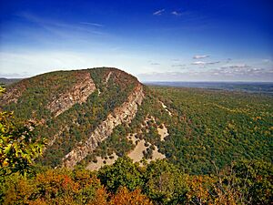
Sunfish Pond is a beautiful, 44-acre (18 ha) lake formed by a glacier during the last ice age. It's surrounded by a forest and is located on the Kittatinny Ridge. The famous Appalachian Trail runs along the lake. Sunfish Pond was named a National Natural Landmark in 1970, meaning it's a special natural place.
Camp Ralph S. Mason is a YMCA camp that started in 1900. It covers 460 acres (190 ha) and offers summer programs for kids. It also hosts other groups throughout the year.
The Pahaquarry Copper Mine is an old, abandoned mine. People tried to mine copper there many times, but it was never very successful. Today, the National Park Service manages the site.
Hardwick Township shares its borders with several other towns. These include Blairstown, Frelinghuysen Township, and Knowlton Township in Warren County. It also borders Stillwater Township and Walpack Township in Sussex County.
Population Changes
| Historical population | |||
|---|---|---|---|
| Census | Pop. | %± | |
| 1810 | 2,528 | — | |
| 1820 | 2,335 | −7.6% | |
| 1830 | 1,962 | * | −16.0% |
| 1840 | 1,957 | −0.3% | |
| 1850 | 727 | * | −62.9% |
| 1860 | 792 | 8.9% | |
| 1870 | 638 | −19.4% | |
| 1880 | 583 | −8.6% | |
| 1890 | 503 | −13.7% | |
| 1900 | 400 | −20.5% | |
| 1910 | 405 | 1.3% | |
| 1920 | 352 | −13.1% | |
| 1930 | 331 | −6.0% | |
| 1940 | 367 | 10.9% | |
| 1950 | 370 | 0.8% | |
| 1960 | 370 | 0.0% | |
| 1970 | 548 | 48.1% | |
| 1980 | 947 | 72.8% | |
| 1990 | 1,235 | 30.4% | |
| 2000 | 1,464 | * | 18.5% |
| 2010 | 1,696 | 15.8% | |
| 2020 | 1,598 | −5.8% | |
| 2023 (est.) | 1,610 | −5.1% | |
| Population sources: 1810–1920 1840 1850–1870 1850 1870 1880–1890 1890–1910 1910–1930 1940–2000 2000 2010 2020 * = Territory chg. in previous decade. |
|||
The population of Hardwick Township has changed quite a bit over the years. In 1810, there were over 2,500 people. By 1950, the population had dropped to around 370. Since then, it has grown steadily. In 2020, the population was 1,598 people.
Education for Students
Students in Hardwick Township attend public schools in nearby towns.
Elementary School
For students in kindergarten through sixth grade, they go to Blairstown Elementary School. This school is part of the Blairstown Township School District. The school boards of Hardwick Township and Blairstown Township joined together on July 1, 2009. This means students from both townships now attend the same elementary school.
High School
Students in seventh through twelfth grades attend North Warren Regional High School. This high school is also located in Blairstown. It serves students from Hardwick, Blairstown, Frelinghuysen, and Knowlton townships.
Other School Options
Students in Warren County, including Hardwick, can also choose to attend other schools. These include the Ridge and Valley Charter School in Frelinghuysen Township for grades K-8. There's also the Warren County Technical School in Washington borough for grades 9-12, which focuses on technical and vocational training.
Transportation in Hardwick
Hardwick Township has a total of about 41.74 miles of roads. Most of these roads are maintained by the township itself.
Major Roads
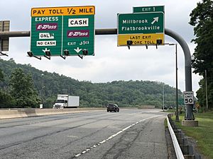
The main roads that go through Hardwick Township are County Route 521 in the eastern part and Interstate 80 in the far west. A part of I-80 includes the Delaware Water Gap Toll Bridge, which connects New Jersey to Pennsylvania.
Historic Road
Old Mine Road is a very scenic road that runs along the Delaware River. It's considered one of the oldest roads in the Northeast that was used for business. It starts in Hardwick near I-80 and continues northeast into Walpack Township.
Notable People from Hardwick Township
Some interesting people have connections to Hardwick Township:
- John Linn (1763–1821), who was a politician and served in the United States House of Representatives.
- Benjamin Lundy (1789–1839), a Quaker who worked to end slavery.
- Lou Reed (1942–2013), a famous rock musician.
See also
 In Spanish: Municipio de Hardwick (Nueva Jersey) para niños
 | Emma Amos |
 | Edward Mitchell Bannister |
 | Larry D. Alexander |
 | Ernie Barnes |


