
Stillwater Township, New Jersey facts for kids
Quick facts for kids
Stillwater Township, New Jersey
|
||
|---|---|---|
|
Township
|
||
_from_SE_1.jpg)
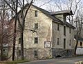
Casper and Abraham Shafer Grist Mill Complex
|
||
|
||

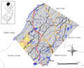
Location of Stillwater Township in Sussex County highlighted in yellow (right). Inset map: Location of Sussex County in New Jersey highlighted in black (left).
|
||

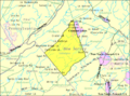
Census Bureau map of Stillwater Township
|
||

Stillwater Township, New Jersey
Location in Sussex County, New Jersey

Stillwater Township, New Jersey
Location in New Jersey

Stillwater Township, New Jersey
Location in the United States
|
||
| Country | ||
| State | ||
| County | ||
| Incorporated | December 27, 1824 | |
| Government | ||
| • Type | Township | |
| • Body | Township Committee | |
| Area | ||
| • Total | 28.25 sq mi (73.17 km2) | |
| • Land | 26.92 sq mi (69.73 km2) | |
| • Water | 1.32 sq mi (3.43 km2) 4.69% | |
| Area rank | 96th of 565 in state 8th of 24 in county |
|
| Elevation | 718 ft (219 m) | |
| Population
(2020)
|
||
| • Total | 4,004 | |
| • Estimate
(2023)
|
4,063 | |
| • Rank | 413th of 565 in state 12th of 24 in county |
|
| • Density | 148.7/sq mi (57.4/km2) | |
| • Density rank | 519th of 565 in state 20th of 24 in county |
|
| Time zone | UTC−05:00 (Eastern (EST)) | |
| • Summer (DST) | UTC−04:00 (Eastern (EDT)) | |
| ZIP Code |
07875
|
|
| Area code | 973 | |
| FIPS code | 34-70890 | |
| GNIS ID | 882262 | |
| Website | ||

Stillwater Township is a community in Sussex County, New Jersey. It's a farming area in the Kittatinny Valley, known for its long history of dairy farming. In 2020, about 4,004 people lived here.
Stillwater was first settled in the 1700s by German families. They came through Philadelphia and settled along the Paulins Kill river. For about 50 years, the village of Stillwater was mainly German. It had a church shared by two different Christian groups, Lutherans and German Reformed.
By the early 1800s, the German population had blended in with other groups. But you can still see signs of their settlement in the old grist mills, lime kilns, and stone houses. Stillwater officially became a township on December 27, 1824. This happened when Sussex County was split to create Warren County. Later, in 1904, a part of Stillwater Township was used to form Fredon Township.
In 2008, New Jersey Monthly magazine named Stillwater Township the 40th best place to live in New Jersey.
Contents
- Stillwater Township: A Look at Its Past
- Stillwater Township: Its Location and Features
- Stillwater Township: Population and People
- Stillwater Township: Schools and Learning
- Stillwater Township: Getting Around
- Stillwater Township: Fun Things to Do
- Stillwater Township: Famous People
- Images for kids
- See also
Stillwater Township: A Look at Its Past


Stillwater Township was officially created on December 27, 1824, by the New Jersey Legislature.
The Historic Shafer Grist Mill
A very important building in Stillwater's history is the Shafer Grist Mill. Casper Shafer first built it in 1741. It was moved in 1764 and rebuilt in 1844. The mill used water from the Paulins Kill river to power its machinery. It kept working until 1955, making it one of New Jersey's oldest water-powered gristmills.
Casper's son, Nathan Armstrong Shafer, lived in Whitehall Manor. This house was built near the center of the village. Aline Murray Kilmer, a famous poet's wife, lived her last years at Whitehall.
Swartswood Lake: A Popular Resort
In the early 1900s, Swartswood Lake became a popular vacation spot. People would take the train to nearby Blairstown to stay at inns like the North Shore Inn. Later, many summer cabins were built, especially for people from Brooklyn.
The Stillwater creamery, where dairy products were made, was built in 1910. Later, a company called Borden, Inc. took it over.
Paulins Kill Lake: From Cottages to Homes
In the 1920s, a dam was built on the Paulins Kill river, creating Paulins Kill Lake. Many summer cottages were built around the lake. These cottages have since grown into a community where people live all year round.
Stillwater Village Landmarks
The Presbyterian Church is a key building in Stillwater village. Across from the church is the old Academy, which was once a schoolhouse. Today, it's home to the Historical Society of Stillwater Township.
Stillwater has always been mainly a farming area. You can still see old lime kilns around. These kilns were used to burn lime to make the soil better for farming. An old kiln still stands on Millbrook Road, about two miles from Stillwater village.
About one-third of Stillwater Township's land was given to create Fredon Township in 1904.
Stillwater Township: Its Location and Features

Stillwater Township covers about 28.25 square miles (73.17 km²). Most of this area, about 26.92 square miles (69.73 km²), is land. The rest, about 1.33 square miles (3.43 km²), is water.
The township shares borders with several other towns. These include Fredon Township, Hampton Township, and Walpack Township in Sussex County. It also borders Frelinghuysen Township and Hardwick Township in Warren County.
Local Communities and Places
- Crandon Lakes is a community partly in Stillwater Township and partly in Hampton Township. In 2010, 496 people lived in the Stillwater part.
- Other small communities and places in the township include Catfish Pond, Duck Pond, Fairview Lake, Five Points, Lake Kathryn, Middleville, Mud Pond, Paulins Kill Lake, Quick Pond, Stillwater, Swartswood, Swartswood Lake, and Wintermutes Foundry.
The Village of Stillwater
Stillwater is a small village with one main street. It was first settled by Johan Peter Bernhardt and his two sons-in-law, John George Wintermute and Casper Shafer.
At the west end of Main Street, where it meets County Route 521, you'll find the First Presbyterian Church of Stillwater. As you go east on Main Street, you'll see Garris's General Store (built in 1876) and "Whitehall" (built in 1785). You can also find Casper Shafer's stonehouse (around 1741) and cross the Paulins Kill river near Shafer's grist mill (1764, rebuilt 1844).
About half a mile south of the Presbyterian church is John George Wintermute's stonehouse (1755) and his son Peter's stonehouse (1791). Next to them is Stillwater Cemetery. This was the site of the first Lutheran-Calvinist church (1771–1838). Many of the town's first settlers are buried here.
Stillwater's Geology and Landscape
Stillwater Township is located in the Ridge and Valley Physiographic Province. It's part of the Kittatinny Valley, which has rolling hills and flat valley floors. This valley is part of the larger Great Appalachian Valley that stretches for 700 miles (1,100 km).
The land in Stillwater Township is generally hilly. There are many ponds and rivers. The most important river is the Paulins Kill. All of Stillwater Township is in the Paulins Kill watershed. This means all the water in the area eventually flows into the Paulins Kill, which then joins the Delaware River.
Stillwater's Climate
| Weather chart for Stillwater Township, New Jersey | |||||||||||||||||||||||||||||||||||||||||||||||
|---|---|---|---|---|---|---|---|---|---|---|---|---|---|---|---|---|---|---|---|---|---|---|---|---|---|---|---|---|---|---|---|---|---|---|---|---|---|---|---|---|---|---|---|---|---|---|---|
| J | F | M | A | M | J | J | A | S | O | N | D | ||||||||||||||||||||||||||||||||||||
|
3.2
36
17
|
2.9
40
19
|
3.7
48
27
|
4
61
37
|
4.1
71
47
|
4.8
79
56
|
4.4
84
61
|
4.3
83
59
|
4.5
75
51
|
4.1
64
39
|
3.7
53
31
|
3.4
41
23
|
||||||||||||||||||||||||||||||||||||
| temperatures in °F precipitation totals in inches source: The Weather Channel |
|||||||||||||||||||||||||||||||||||||||||||||||
|
Metric conversion
|
|||||||||||||||||||||||||||||||||||||||||||||||
Stillwater Township is in Northwestern New Jersey. It has a humid continental climate. This means it has cooler weather because it's located at higher elevations.
Stillwater Township: Population and People
| Historical population | |||
|---|---|---|---|
| Census | Pop. | %± | |
| 1830 | 1,381 | — | |
| 1840 | 1,476 | 6.9% | |
| 1850 | 1,742 | 18.0% | |
| 1860 | 1,816 | 4.2% | |
| 1870 | 1,632 | −10.1% | |
| 1880 | 1,502 | −8.0% | |
| 1890 | 1,296 | −13.7% | |
| 1900 | 1,108 | −14.5% | |
| 1910 | 796 | * | −28.2% |
| 1920 | 671 | −15.7% | |
| 1930 | 706 | 5.2% | |
| 1940 | 679 | −3.8% | |
| 1950 | 816 | 20.2% | |
| 1960 | 1,339 | 64.1% | |
| 1970 | 2,158 | 61.2% | |
| 1980 | 3,887 | 80.1% | |
| 1990 | 4,253 | 9.4% | |
| 2000 | 4,267 | 0.3% | |
| 2010 | 4,099 | −3.9% | |
| 2020 | 4,004 | −2.3% | |
| 2023 (est.) | 4,063 | −0.9% | |
| Population sources: 1830–1920 1840 1850–1870 1850 1870 1880–1890 1890–1910 1910–1930 1940–2000 2000 2010 * = Lost territory in previous decade. |
|||
Population Details from 2010
The 2010 United States census counted 4,099 people living in Stillwater Township. There were 1,553 households and 1,141 families. The population density was about 151.5 people per square mile (58.5/km²).
Most of the people (97.07%) were White. A smaller number were Black or African American (0.66%), Asian (0.71%), or from other groups. About 2.20% of the population was Hispanic or Latino.
- Households:
* 30.0% had children under 18. * 61.4% were married couples. * 7.6% had a female head of household with no husband. * 26.5% were not families. * 21.6% were individuals living alone. * 6.1% had someone 65 or older living alone.
- The average household had 2.64 people, and the average family had 3.09 people.
- Age Breakdown:
* 21.9% were under 18. * 8.1% were 18 to 24. * 22.0% were 25 to 44. * 36.8% were 45 to 64. * 11.2% were 65 or older.
- The average age was 43.8 years. For every 100 females, there were about 97.9 males.
In 2010, the average household income was $79,367, and the average family income was $94,900. About 7.2% of the population lived below the poverty line. This included 12.2% of those under 18 and 6.1% of those 65 or older.
Stillwater Township: Schools and Learning
The Stillwater Township School District serves students from pre-kindergarten through sixth grade. These students attend Stillwater Township School. In the 2018–19 school year, the school had 254 students and 29.3 teachers. This means there were about 8.7 students for every teacher.
Students in seventh through twelfth grade attend Kittatinny Regional High School. This high school is located in Hampton Township. It serves students from Stillwater, Fredon Township, Hampton Township, Sandyston Township, and Walpack Township.
Kittatinny Regional High School is on a 96-acre (39 ha) campus. In the 2018–19 school year, it had 941 students and 97.5 teachers. This means there were about 9.7 students for every teacher. The high school was recognized as a National Blue Ribbon School of Excellence in 1997–1998.
Stillwater Township: Getting Around
_at_Spout_Hill_Road_in_Stillwater_Township,_Sussex_County,_New_Jersey.jpg)
As of 2010, Stillwater Township had about 60.77 miles (97.80 km) of roads. The local government maintained 39.87 miles (64.16 km) of these roads. Sussex County maintained the other 20.90 miles (33.64 km).
No major Interstate, U.S., or state highways pass through Stillwater Township. The most important road in the township is County Route 521.
Stillwater Township: Fun Things to Do
Parks and Outdoor Activities
Stillwater is home to Swartswood State Park. This park was created in 1914 and was the very first state park in New Jersey. Inside the park, you'll find Little Swartswood and Swartswood Lake. The New Jersey Division of Parks and Forestry manages and takes care of the park.
Stillwater Township: Famous People
Here are some notable people who have lived in or are connected to Stillwater Township:
- Rev. Elbert Nevius Condit (1846–1900), a Presbyterian minister and the third president of Occidental College.
- Louis Finkelstein (1923–2000), a painter, art critic, and professor at Queens College.
- Gretna Campbell Finkelstein (1922–1987), an artist connected to the New York School, and wife of Louis Finkelstein.
- Aaron Hankinson (1735–1806), a brigadier general in the Revolutionary War and a New Jersey state assemblyman.
- Aline Murray Kilmer (1888–1941), a poet and author, and the wife of poet Joyce Kilmer.
- Casper Shafer (around 1711–1784), one of the first settlers and a colonial politician.
- Matt Valenti (born 1984), a two-time NCAA Division I national champion wrestler from the University of Pennsylvania.
Images for kids
-
Casper and Abraham Shafer Grist Mill Complex
-
Stillwater Township Seal
-
Location of Stillwater Township in Sussex County
-
Census Bureau map of Stillwater Township
See also
 In Spanish: Municipio de Stillwater (Nueva Jersey) para niños
