Walpack Township, New Jersey facts for kids
Quick facts for kids
Walpack Township, New Jersey
|
|
|---|---|
|
Township
|
|
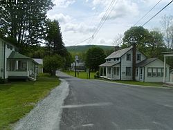
The downtown of Wallpack Center, New Jersey facing National Park Service Route 615
|
|
| Motto(s):
Oldest Municipality in Sussex County
|
|
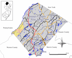
Location in Sussex County, New Jersey and of Sussex County in New Jersey (upper right)
|
|
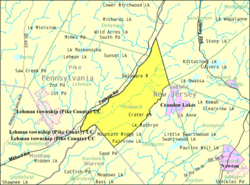
Census Bureau map of Walpack Township, New Jersey
|
|
| Country | |
| State | |
| County | |
| Earliest mention | October 26, 1731 |
| Incorporated | February 21, 1798 |
| Government | |
| • Type | Township |
| • Body | Township Committee |
| Area | |
| • Total | 24.88 sq mi (64.45 km2) |
| • Land | 24.24 sq mi (62.77 km2) |
| • Water | 0.65 sq mi (1.68 km2) 2.60% |
| Area rank | 109th of 565 in state 10th of 24 in county |
| Elevation | 436 ft (133 m) |
| Population
(2020)
|
|
| • Total | 7 |
| • Estimate
(2023)
|
6 |
| • Rank | 565th of 565 in state 24th of 24 in county |
| • Density | 0.3/sq mi (0.1/km2) |
| • Density rank | 565th of 565 in state 24th of 24 in county |
| Time zone | UTC−05:00 (Eastern (EST)) |
| • Summer (DST) | UTC−04:00 (Eastern (EDT)) |
| ZIP Code |
07881 – Walpack Center
|
| Area code(s) | 908 |
| FIPS code | 3403776640 |
| GNIS feature ID | 0882259 |
Walpack Township is a small town, also called a township, located in Sussex County, in the state of New Jersey. In 2020, only 7 people lived there, making it one of the smallest towns in New Jersey. Its population has become much smaller over the years.
The name "Walpack" comes from a Lenape Native American word. It means "turn-hole," which describes an eddy or whirlpool in water. Other ideas suggest it means "very deep water" or a "sudden bend of a stream."
Contents
Walpack's History: From Early Days to Today
Walpack Township was first mentioned on October 26, 1731, under the name Walpake. It was part of Hunterdon County back then. Later, it became part of Morris County in 1739. Finally, in 1753, it joined the new Sussex County.
On February 21, 1798, Walpack officially became a township. Over time, parts of Walpack were used to create other townships. These include Montague Township (in 1759) and Sandyston Township (in 1762). In 1935, Walpack gained some land from Stillwater Township.
Important Historic Places in Walpack
The Andrew Snable House was built in 1801. It was added to the National Register of Historic Places in 1979. This list includes places important to American history. The Wallpack Center Historic District, which is a whole area with many historic buildings, was also added to this list in 1980.
The Tocks Island Dam Project
In 1962, there was a plan to build a large dam called the Tocks Island Dam on the Delaware River. This dam was meant to stop floods. If built, it would have created a huge lake, about 40 miles long.
For this project, the government bought about 72,000 acres of land, including Walpack. Many people who had lived in the area for a long time had to move. However, the dam was never built. The project stopped because of high costs, new environmental laws, and local people protesting. In 1978, parts of the Delaware River were protected, which officially ended the dam project.
Music Festivals and Safety Rules
In 1970, there was a plan for a big rock music festival in Walpack. A judge said no to the festival. This led to new rules for large events like concerts. These rules make sure organizers plan for traffic and safety with local officials. They also set limits on how long events can last. The judge said that any good things from such an event must be balanced with the safety of young people and the public.
Walpack's Geography and Natural Beauty
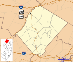
Walpack Township covers about 24.88 square miles (64.45 square kilometers). Most of this area is land, with a small part being water. The township is located in the Minisink Valley. This valley stretches from the Delaware Water Gap up to Port Jervis, New York.
Communities and Neighboring Towns
Within Walpack Township, you can find small communities and places like Dry Pond, Flat Brook, and Walpack Center.
Walpack Township shares its borders with other towns. These include Sandyston Township and Stillwater Township in Sussex County. It also borders Hardwick Township in Warren County.
Population Changes in Walpack
| Historical population | |||
|---|---|---|---|
| Census | Pop. | %± | |
| 1810 | 591 | — | |
| 1820 | 822 | 39.1% | |
| 1830 | 660 | * | −19.7% |
| 1840 | 728 | 10.3% | |
| 1850 | 783 | 7.6% | |
| 1860 | 851 | 8.7% | |
| 1870 | 647 | −24.0% | |
| 1880 | 575 | −11.1% | |
| 1890 | 436 | −24.2% | |
| 1900 | 371 | −14.9% | |
| 1910 | 286 | −22.9% | |
| 1920 | 258 | −9.8% | |
| 1930 | 178 | −31.0% | |
| 1940 | 207 | * | 16.3% |
| 1950 | 204 | −1.4% | |
| 1960 | 248 | 21.6% | |
| 1970 | 384 | 54.8% | |
| 1980 | 150 | −60.9% | |
| 1990 | 67 | −55.3% | |
| 2000 | 41 | −38.8% | |
| 2010 | 16 | −61.0% | |
| 2020 | 7 | −56.2% | |
| 2023 (est.) | 6 | −62.5% | |
| Population sources: 1810–1920 1840 1850–1870 1850 1870 1880–1890 1890–1910 1910–1930 1940–2000 2000 2010 2020 * = Territorial change in previous decade. |
|||
The population of Walpack Township has changed a lot over the years. In 2010, there were 16 people living there. By 2020, this number had dropped to just 7. This makes Walpack one of the least populated places in New Jersey.
Education for Walpack Students
Students in Walpack Township attend schools through a shared district with Sandyston Township.
Elementary School
Children from kindergarten to sixth grade go to the Sandyston-Walpack Consolidated School District. This school is in the Layton area of Sandyston Township. In the 2022–23 school year, the school had 120 students and about 15 teachers. This means there were about 8 students for every teacher.
High School
Students in seventh through twelfth grade from Walpack and Sandyston Townships attend Kittatinny Regional High School. This high school is located in Hampton Township. It also serves students from Fredon Township and Stillwater Township.
Kittatinny Regional High School is on a 96-acre campus. It was recognized as a "National Blue Ribbon School of Excellence" in 1997–98. In the 2022–23 school year, the high school had 781 students and about 80 teachers. This means there were about 10 students for every teacher.
Getting Around Walpack: Transportation
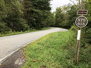
As of 2010, Walpack Township had about 20 miles of roads. All of these roads are maintained by the township itself. One of the main routes in the township is National Park Service Route 615.
Notable People from Walpack Township
- Frank Chapot (1932–2016), an Olympic silver medalist in horse riding, was associated with Walpack Township.
See also
 In Spanish: Municipio de Walpack para niños
 | Sharif Bey |
 | Hale Woodruff |
 | Richmond Barthé |
 | Purvis Young |


