Montague Township, New Jersey facts for kids
Quick facts for kids
Montague Township, New Jersey
|
||
|---|---|---|
|
Township
|
||
|
||
|
||
| Nickname(s):
"The Top of New Jersey"
|
||
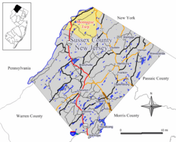
Map of Montague Township in Sussex County. Inset: Location of Sussex County highlighted in the State of New Jersey.
|
||
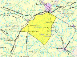
Census Bureau map of Montague Township, New Jersey.
|
||
| Country | ||
| State | ||
| County | ||
| Royal patent | March 26, 1759 | |
| Incorporated | February 21, 1798 | |
| Government | ||
| • Type | Township | |
| • Body | Township Committee | |
| Area | ||
| • Total | 46.63 sq mi (120.77 km2) | |
| • Land | 45.23 sq mi (117.15 km2) | |
| • Water | 1.40 sq mi (3.62 km2) 3.00% | |
| Area rank | 38th of 565 in state 3rd of 24 in county |
|
| Elevation | 1,066 ft (325 m) | |
| Population
(2020)
|
||
| • Total | 3,792 | |
| • Estimate
(2023)
|
3,850 | |
| • Rank | 421st of 565 in state 13th of 24 in county |
|
| • Density | 83.8/sq mi (32.4/km2) | |
| • Density rank | 547th of 565 in state 22nd of 24 in county |
|
| Time zone | UTC−05:00 (Eastern (EST)) | |
| • Summer (DST) | UTC−04:00 (Eastern (EDT)) | |
| ZIP Code |
07827
|
|
| Area code(s) | 973 Exchanges: 293, 948 | |
| FIPS code | 3403747430 | |
| GNIS feature ID | 0882256 | |
Montague Township is a special kind of town called a township in Sussex County, New Jersey. It's part of the big New York City Metropolitan Area.
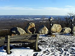
In 2020, about 3,792 people lived here. Montague is famous for being home to High Point, which is the highest spot in all of New Jersey! It's 1,803 feet (550 meters) above sea level. It's also the northernmost town in New Jersey.
A lot of Montague Township is made up of public lands. These include High Point State Park, Stokes State Forest, and parts of the Delaware Water Gap National Recreation Area. Montague is known for its beautiful views and amazing wildlife. In the summer, people love to go hiking, biking, camping, and fishing here.
The name "Montague" has a few possible origins. It might have been named after George Montagu, a duke, by King George II in 1759. Or maybe it was named after Lady Mary Wortley Montagu, a popular writer. Another idea is that it was named for a lawyer named John Montague. Montague became an official township on February 21, 1798. It was one of the first 104 townships in New Jersey.
Montague Township is unique because it's the only town in New Jersey that borders both New York and Pennsylvania. It's a quiet, rural area, so you won't find any traffic lights here! Before the 1980s, mail for Montague residents came through a New York ZIP code. This meant some people had New Jersey driver's licenses but a New York mailing address.
Contents
Exploring Montague's Geography
Montague Township covers about 46.63 square miles (120.77 square kilometers). Most of this area is land, with a small part being water.
Local Communities and Landmarks
Within Montague Township, you can find several small communities and places. These include Brick House, Duttonville, Four Corners, High Point, and Lake Marcia. You can also find Mashipacong Island, Mashipacong Pond, Millville, and Minisink Island.
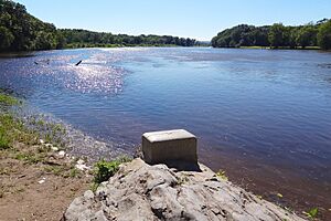
The Tri-States Monument is a special marker. It shows where the borders of New Jersey, New York, and Pennsylvania all come together. This spot is also the very northernmost point of New Jersey.
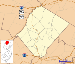
Montague Township shares its borders with Sandyston Township and Wantage Township in Sussex County. It also borders New York State.
A large part of Montague Township, about 70% or more, is owned by the government. This means only about 30% of the land is available for building and development.
Montague's Climate and Weather
Montague Township has a humid continental climate. This means it has big changes in temperature throughout the year. Summers are warm to hot and often humid. Winters are cold, and sometimes very cold.
Montague's Population and People
| Historical population | |||
|---|---|---|---|
| Census | Pop. | %± | |
| 1810 | 661 | — | |
| 1820 | 964 | 45.8% | |
| 1830 | 990 | 2.7% | |
| 1840 | 1,025 | 3.5% | |
| 1850 | 1,010 | −1.5% | |
| 1860 | 983 | −2.7% | |
| 1870 | 932 | −5.2% | |
| 1880 | 1,022 | 9.7% | |
| 1890 | 797 | −22.0% | |
| 1900 | 710 | −10.9% | |
| 1910 | 621 | −12.5% | |
| 1920 | 534 | −14.0% | |
| 1930 | 581 | 8.8% | |
| 1940 | 621 | 6.9% | |
| 1950 | 602 | −3.1% | |
| 1960 | 879 | 46.0% | |
| 1970 | 1,131 | 28.7% | |
| 1980 | 2,066 | 82.7% | |
| 1990 | 2,832 | 37.1% | |
| 2000 | 3,412 | 20.5% | |
| 2010 | 3,847 | 12.7% | |
| 2020 | 3,792 | −1.4% | |
| 2023 (est.) | 3,850 | 0.1% | |
| Population sources: 1810–1920 1840 1850–1870 1850 1870 1880–1890 1890–1910 1910–1930 1940–2000 2000 2010 2020 |
|||
Many people who live in Montague Township moved there in the 1980s and 1990s. The community is mostly made up of people from similar backgrounds.
What the 2010 Census Showed
In 2010, there were 3,847 people living in Montague Township. There were 1,535 households, which are groups of people living together. Most people (about 92%) were White. About 2.6% were Black or African American, and 1% were Asian. About 6.4% of the population identified as Hispanic or Latino.
The average household had 2.50 people. About 22.8% of the population was under 18 years old. The median age was 42.3 years. This means half the people were younger than 42.3 and half were older.
Economy and Local Businesses
The main business area in Montague Township is along New Jersey Route 23. In 2019, there were five gas stations there. Business at these gas stations changed after a New Jersey tax increase in 2016. Before that, drivers from nearby states would often stop in New Jersey for cheaper gas.
Fun Things to Do: Parks and Recreation
Montague Township offers many outdoor activities because of its large public lands. These areas are great for enjoying nature.
Learning in Montague: Education
Students in Montague Township go to public schools.
Montague Township School District
Younger students, from pre-kindergarten through eighth grade, attend schools in the Montague Township School District. As of the 2023–24 school year, the district has one school with 309 students. There are 37.5 teachers, meaning about 8 students for every teacher.
High School Education
Students in ninth through twelfth grades attend High Point Regional High School. This high school also serves students from several other nearby towns. In the 2023–24 school year, High Point Regional High School had 803 students and 73.2 teachers. This means there were about 11 students for every teacher.
Some students can also choose to attend Sussex County Technical School. This school accepts students based on a special selection process. There is also a middle school charter program in Sparta Township that students can attend.
Getting Around: Transportation
Montague Township is a rural area. As of 2019, there are no traffic lights in the entire town!
Montague Township has many miles of roads. Some are maintained by the town, some by Sussex County, and some by the state.
Three main roads pass through Montague Township:
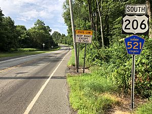
- U.S. Route 206 goes through the western part of the township. It crosses the Delaware River at the Milford-Montague Toll Bridge.
- Route 23 runs through the eastern part. It's the entrance road to High Point State Park and ends at the New York border.
- County Route 521 also goes through the township, heading northeast.
The closest major highway is Interstate 84, which is just over the state line in New York.
You'll find several gas stations in the northern part of the township along Route 23. Historically, gas was much cheaper in New Jersey than in nearby Pennsylvania or New York.
Famous People from Montague
Many interesting people have lived in or are connected to Montague Township:
- Ed Banach (born 1960) and Lou Banach (born 1960): Brothers who both won gold medals in Freestyle Wrestling at the 1984 Summer Olympics.
- John Westbrook Hornbeck (1804–1848): A member of the U.S. House of Representatives for Pennsylvania.
- Daniel Myers Van Auken (1826–1908): Also a member of the U.S. House of Representatives for Pennsylvania.
- Kinuyo Yamashita: A video game music composer, known for her music in Castlevania.
- Paul Zindel (1936–2003): A playwright and young adult novelist, who wrote The Effect of Gamma Rays on Man-in-the-Moon Marigolds.
Wineries
- Westfall Winery - This winery is no longer open. It has been replaced by a farm animal sanctuary.
See also
 In Spanish: Municipio de Montague (Nueva Jersey) para niños
 | Janet Taylor Pickett |
 | Synthia Saint James |
 | Howardena Pindell |
 | Faith Ringgold |


