
Tri-States Monument facts for kids

Tri-States Monument, 2009
|
|
| Location | Tripoint for the states of New Jersey, New York, and Pennsylvania |
|---|---|
| Material | Granite |
The Tri-States Monument (also called Tri-State Rock) is a special stone that shows where the borders of three states meet. These states are New Jersey, New York, and Pennsylvania. It sits at a unique spot where the Delaware and Neversink rivers join. This place is also known as Carpenter's Point.
A taller stone nearby, called the Witness Monument, helps people find the Tri-States Monument. It's not directly on a state border. Instead, it points to where the three states meet and also to a corner point between New York and Pennsylvania in the Delaware River. The Tri-States Monument is also the northernmost point in New Jersey, located in Montague Township, Sussex County.
How the Borders Were Decided
In 1664, a long time ago, King Charles II of England gave a large area of land to his brother, James, the Duke of York. This land included what was then called New Netherlands. Later that same year, the Duke of York divided this land between the Hudson River and the Delaware River. He gave parts of it to Sir George Carteret and Lord Berkeley of Stratton.
The western and northern border of this new land was described as running along the Delaware River. It went as far north as the river's most northern branch, which was at a certain latitude (41 degrees, 40 minutes). From there, it was supposed to go in a straight line to the 41st latitude on the Hudson River. This area was then named New Caeserea, or New Jersey.
Building the Monument
In December 1872, experts from New Jersey started to survey, or carefully measure, the border between New Jersey and New York. In 1874, another group, the U.S. Coast and Geodetic Survey, found an old mark on the bedrock. They put a copper pipe filled with lead into a deep hole there.
This copper pipe was later replaced in 1882 with a granite monument, similar to the Witness Monument you can see today. However, strong ice flows in the river broke off the top part of this new monument by the spring of 1883. So, on May 21, 1885, the remaining part of the monument was fixed up to become what we see now.
What the Monument Looks Like

The Tri-States Monument is about 2 feet 4 inches (71 cm) long, 1 foot 4 inches (41 cm) wide, and 1 foot 5 inches (43 cm) high above the rock. On its top surface, you can see the first letters of the three states' names carved into it: "NJ" for New Jersey, "NY" for New York, and "PA" for Pennsylvania. There are also lines carved into the stone that show where the state borders meet. The words "Tri States Monument" are carved on its north side. It sits right by the water's edge, near where the river water usually reaches its highest point.
For many years, a bronze survey marker was in the middle of the monument's top. It was put there in 1942 and helped surveyors find exact locations.


The Witness Monument has "Boundary Monument" and the year 1882 carved on both sides. On its east side, it says "Witness Monument." The side facing New Jersey (south) explains how to find the Tri-States Monument: "South 64 degrees W. 72 1/4 feet from this is the Tri State Rock." It also lists the people who helped with the survey from New Jersey. The side facing New York (north) explains where the border between New York and Pennsylvania is in the Delaware River. It also lists the people who helped from New York.
Gallery
-
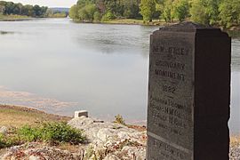
Overlooking the Tri-States Monument and the Delaware River from the Witness Monument
-
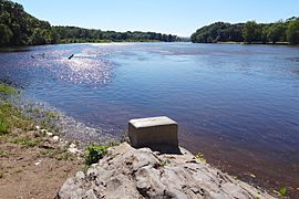
Looking southwest along the Delaware River, with Sussex County, New Jersey on the left and Pike County, Pennsylvania on the right
-
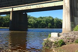
Looking north under the Interstate 84 bridge and along the Delaware River toward Matamoras, Pennsylvania
-
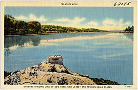
Postcard view
-
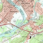
Topographic map showing state boundaries


.jpg)
,_NJ-NY-PA_Tri-States_Monument_detail.jpg)
