
Matamoras, Pennsylvania facts for kids
Quick facts for kids
Matamoras, Pennsylvania
|
|
|---|---|
| Borough of Matamoras | |

A view of Matamoras from the hills behind the town. Mid-Delaware Bridge connects it to Port Jervis, New York
|
|
| Country | United States |
| State | Pennsylvania |
| County | Pike |
| Incorporated | January 18, 1905 |
| Area | |
| • Total | 0.78 sq mi (2.02 km2) |
| • Land | 0.69 sq mi (1.79 km2) |
| • Water | 0.09 sq mi (0.23 km2) |
| Elevation | 427 ft (130 m) |
| Population
(2020)
|
|
| • Total | 2,362 |
| • Density | 3,408.37/sq mi (1,316.37/km2) |
| Time zone | UTC-5 (EST) |
| • Summer (DST) | UTC-4 (EDT) |
| ZIP code |
18336
|
| Area code(s) | 570 |
| FIPS code | 42-48048 |
| Website | Borough of Matamoras |
Matamoras is a small town, called a borough, located in Pike County, Pennsylvania, in the United States. In 2020, about 2,362 people lived there. It's special because it's the very easternmost town in all of Pennsylvania! Matamoras is also considered part of the larger New York metropolitan area, which includes big cities like New York City.
Contents
History of Matamoras
Matamoras was once part of a bigger area called Westfall Township. The town got its name from a city in Mexico called Matamoros. This Mexican city was the first one taken over by U.S. troops during the Mexican–American War. Matamoras officially became a borough on January 18, 1905. This means it got its own local government.
Merrill-Ronne Airport: A Look Back
On May 31, 1930, a new place opened in Matamoras called the Merrill-Ronne Airport. This airport was named after two brave pilots, Mazel M. Merrill and Edwin Ronne. They had sadly crashed and died in the woods near Milford, Pennsylvania.
The airport had two large runways and a smaller one. During World War II, it was an important place where fighter pilots learned how to fly. The Merrill-Ronne Airport closed down sometime between 1970 and 1980. After it closed, the land was turned into a fun local spot called Airport Park, which has many things to do.
Geography of Matamoras
Matamoras is located at coordinates 41°22′N 74°42′W / 41.367°N 74.700°W. It is the most eastern point in the state of Pennsylvania. If you look across the Delaware River, you'll see Port Jervis, New York and Montague, New Jersey.
Close by, where the Delaware River meets the Neversink River, there's a special spot called the Tri-States Monument. This monument marks the exact place where the borders of New York, New Jersey, and Pennsylvania all meet!
The United States Census Bureau says that Matamoras covers about 0.8 square miles in total. Most of this area, about 0.7 square miles, is land. The rest, about 0.1 square miles, is water.
-
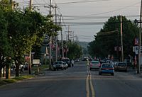
US Routes 6 and 209 as they pass through Matamoras.
-
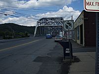
Facing the bridge to Port Jervis, New York on US Routes 6 and 209
-
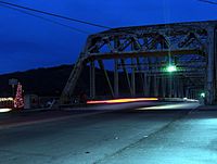
The Mid Delaware Bridge
-
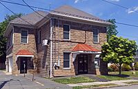
Borough Hall


Population and People
| Historical population | |||
|---|---|---|---|
| Census | Pop. | %± | |
| 1880 | 196 | — | |
| 1910 | 1,388 | — | |
| 1920 | 1,535 | 10.6% | |
| 1930 | 1,784 | 16.2% | |
| 1940 | 1,735 | −2.7% | |
| 1950 | 1,761 | 1.5% | |
| 1960 | 2,087 | 18.5% | |
| 1970 | 2,244 | 7.5% | |
| 1980 | 2,111 | −5.9% | |
| 1990 | 1,934 | −8.4% | |
| 2000 | 2,312 | 19.5% | |
| 2010 | 2,469 | 6.8% | |
| 2020 | 2,362 | −4.3% | |
| Sources: | |||
In 2010, there were 2,469 people living in Matamoras. These people lived in 955 homes, and 665 of these were families. The town had about 3,527 people per square mile.
Many different people live in Matamoras. Most residents are White, with smaller groups of African American, Native American, and Asian people. About 5.5% of the population identified as Hispanic or Latino.
About 33.7% of the homes had children under 18 years old living in them. The average home had about 2.59 people, and the average family had about 3.09 people.
The population is spread out by age. About 26.2% of the people were under 18 years old. About 16% were 65 years old or older. The average age in Matamoras was 39 years old.
Other Interesting Facts
- Matamoras is the place where photographer Amy Stein created her famous Domesticated photo series.
See also
 In Spanish: Matamoras (Pensilvania) para niños
