Warminster Heights, Pennsylvania facts for kids
Quick facts for kids
Warminster Heights, Pennsylvania
Lacey Park
|
|
|---|---|

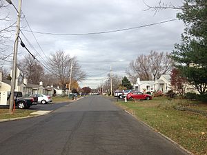
Jamison Street in Warminster Heights
|
|
| Nickname(s):
LP, LPP, Lacey Park Projects, Parkers, The Park
|
|

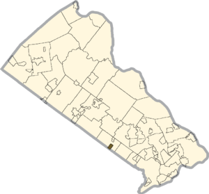
Location of Warminster Heights in Bucks County
|
|
| Country | United States |
| State | Pennsylvania |
| County | Bucks |
| Township | Warminster |
| Area | |
| • Total | 0.6 sq mi (2 km2) |
| • Land | 0.6 sq mi (2 km2) |
| • Water | 0.0 sq mi (0 km2) |
| Elevation | 315 ft (96 m) |
| Population
(2010)
|
|
| • Total | 4,124 |
| • Density | 6,900/sq mi (2,650/km2) |
| Time zone | UTC-5 (Eastern (EST)) |
| • Summer (DST) | UTC-4 (EDT) |
| ZIP code |
18974
|
| Area codes | 215, 267, and 445 |
| GNIS feature ID | 1193608 |
Warminster Heights is a special kind of community called a census-designated place. It's part of Warminster Township in Bucks County, Pennsylvania, United States. It's located close to Hatboro in Montgomery County. In 2010, about 4,124 people lived here.
Contents
History of Warminster Heights
This neighborhood was built in 1943. It was first used as homes for workers at the Brewster Aeronautical Corporation. This company made airplanes and started in 1941. At that time, the area was known as Johnsville.
Later, the area became a big research center for the Navy, called the Naval Air Development Center. It was eventually closed by the US government in the mid-1990s.
From Lacey Park to Warminster Heights
The community was first named Lacey Park. It was named after General John Lacey. He was a Pennsylvania Militia General who fought in the American Revolutionary War. A battle he fought, the Battle of Crooked Billet, happened near this neighborhood.
In the 1960s, Lacey Park was renamed Warminster Heights. Even today, many older people in the area still call it Lacey Park.
Changes and Improvements
For a while, Warminster Heights had some challenges. It was known as a place with lower-cost homes. These homes were built by the US government in the 1940s. Many were made of cinder blocks and had four homes in each building.
Between 1957 and 1975, the homes were owned by private companies. Then, in 1975, the Redevelopment Authority of Bucks County took over. They managed the properties. In 1986, the homes were turned over to a group called the Warminster Heights Home Owners' Association. This group is a housing cooperative, which means the residents help own and manage the homes. They started making many improvements to the houses.
The neighborhood has worked hard to improve its image and become a better place to live.
Historic Landmark
A historic building called Craven Hall was added to the National Register of Historic Places in 2007. This means it's an important place recognized for its history.
Geography of Warminster Heights
Warminster Heights is located at 40°11′10″N 75°5′6″W / 40.18611°N 75.08500°W.
The area covers about 0.6 square miles (1.6 square kilometers) of land. There is no water within its borders.
People of Warminster Heights
In 2010, Warminster Heights had 4,124 residents.
The people living here come from many different backgrounds:
- About 60.7% were White.
- About 10.6% were African American.
- About 3.3% were Asian.
- About 18.4% were from other races.
- About 5.9% were from two or more races.
- About 35.1% of the people were Hispanic or Latino.
In 2000, there were 1,523 households in Warminster Heights. A household is a group of people living together. About 36.1% of these households had children under 18 living with them. The average household had about 2.74 people.
The median age of people in Warminster Heights was 30 years old. This means half the people were younger than 30, and half were older.
Education in Warminster Heights
The Centennial School District serves the children living in Warminster Heights. This is the public school district for the area.
There was also a private school called Delaware Valley Private School, but it is no longer open.
Getting Around and Services
Transportation
Several main roads are close to Warminster Heights. These include Pennsylvania Route 132 (Street Road) and Pennsylvania Route 332 (Jacksonville Road).
SEPTA provides bus service in the area. Route 22 bus can take you to Willow Grove and Olney Transportation Center in North Philadelphia. The Warminster train station is also nearby. From there, you can take the SEPTA Regional Rail's Warminster Line to Center City Philadelphia.
Utilities and Services
- Electricity and Natural Gas: These services are provided by PECO Energy Company.
- Trash and Recycling: J.P. Mascaro & Sons collects trash and recycling.
- Internet, Cable, and Phone: You can get these services from Xfinity and Verizon.
- Water and Sewer: The Warminster Municipal Authority provides water and sewer services.
- Area Codes: The phone area codes for Warminster Heights are area codes 215, 267, and 445.
See also
 In Spanish: Warminster Heights para niños
 | Audre Lorde |
 | John Berry Meachum |
 | Ferdinand Lee Barnett |


