Feasterville, Pennsylvania facts for kids
Quick facts for kids
Feasterville, Pennsylvania
|
|
|---|---|

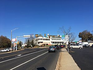
Intersection of Bustleton Pike and Bridgetown Pike in Feasterville
|
|

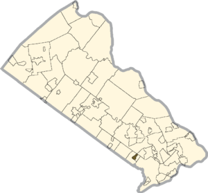
Location of Feasterville in Bucks County
|
|
| Country | United States |
| State | Pennsylvania |
| County | Bucks |
| Township | Lower Southampton |
| Area | |
| • Total | 0.64 sq mi (1.67 km2) |
| • Land | 0.64 sq mi (1.67 km2) |
| • Water | 0.00 sq mi (0.00 km2) |
| Elevation | 220 ft (70 m) |
| Population
(2020)
|
|
| • Total | 3,066 |
| • Density | 4,768.27/sq mi (1,839.68/km2) |
| Time zone | UTC-5 (Eastern (EST)) |
| • Summer (DST) | UTC-4 (EDT) |
| ZIP code |
19053
|
| Area code(s) | 215, 267 and 445 |
| GNIS feature ID | 1192454 |
Feasterville is a small community in Bucks County, Pennsylvania, in the United States. It is known as a census-designated place (CDP), which means it's an area identified by the U.S. Census Bureau for statistical purposes.
Feasterville used to be part of a larger area called Feasterville-Trevose. However, it was later divided into two separate CDPs: Feasterville and Trevose. In 2010, about 3,074 people lived in Feasterville. The population has grown a little since 2006.
Contents
People Living in Feasterville
| Historical population | |||
|---|---|---|---|
| Census | Pop. | %± | |
| 2020 | 3,066 | — | |
| U.S. Decennial Census | |||
In 2014, Feasterville had about 3,656 residents. Most of the people living there, about 94.47%, were White. About 4.68% were Hispanic or Latino, 3.06% were Black or African American, and 2.46% were Asian.
Many people in Feasterville were born in other countries, making up about 17.94% of the population. There is also a large community of people from Russia.
Schools and Education
Students in Feasterville attend public schools that are part of the Neshaminy School District.
Elementary Schools
Younger students, from kindergarten to fourth grade, go to one of two elementary schools:
- Joseph Ferderbar Elementary School
- Tawanka Elementary School
The school they attend depends on where they live in the township.
Middle and High Schools
- Students in grades 5-8 attend Poquessing Middle School.
- For high school, students in grades 9-12 go to Neshaminy High School.
Catholic Schools
There is also a local Catholic school called St. Katharine Drexel Regional Catholic School. It is located nearby in Holland. This school was formed in 2012 when two other Catholic schools, Assumption B.V.M. Catholic School in Feasterville and St. Bede the Venerable School in Holland, joined together.
Weather and Climate
Feasterville has a climate known as a Hot-summer Humid continental climate. This means it has warm, humid summers and cold winters.
Temperature and Humidity
- Summers often have hot and humid days.
- The highest temperature recorded since 1981 was 102.9°F (39.4°C) on July 22, 2011.
- Winters can be very cold with strong winds.
- The coldest temperature recorded since 1981 was -9.2°F (-22.9°C) on January 22, 1984.
Rainfall and Snowfall
- July is usually the wettest month, with many thunderstorms.
- The most rain in one day was 6.73 inches (171 mm) on August 27, 2011.
- On average, Feasterville gets about 25.1 inches (64 cm) of snow each year.
- Big snowstorms, with 12 inches (30 cm) or more of snow, happen every few years. These often occur during winter storms called nor’easters.
| Climate data for Feasterville. Elevation: 213 feet (65 m), 1981–2010 normals, extremes 1981–2019 | |||||||||||||
|---|---|---|---|---|---|---|---|---|---|---|---|---|---|
| Month | Jan | Feb | Mar | Apr | May | Jun | Jul | Aug | Sep | Oct | Nov | Dec | Year |
| Record high °F (°C) | 71.6 (22.0) |
77.9 (25.5) |
87.3 (30.7) |
94.2 (34.6) |
95.4 (35.2) |
96.5 (35.8) |
102.9 (39.4) |
100.5 (38.1) |
98.3 (36.8) |
93.7 (34.3) |
81.3 (27.4) |
76.1 (24.5) |
102.9 (39.4) |
| Mean daily maximum °F (°C) | 39.9 (4.4) |
43.1 (6.2) |
51.3 (10.7) |
63.1 (17.3) |
72.6 (22.6) |
81.8 (27.7) |
86.0 (30.0) |
84.4 (29.1) |
77.6 (25.3) |
66.2 (19.0) |
55.4 (13.0) |
44.2 (6.8) |
63.9 (17.7) |
| Daily mean °F (°C) | 31.9 (−0.1) |
34.4 (1.3) |
41.8 (5.4) |
52.5 (11.4) |
61.9 (16.6) |
71.4 (21.9) |
76.1 (24.5) |
74.6 (23.7) |
67.5 (19.7) |
55.9 (13.3) |
46.2 (7.9) |
36.4 (2.4) |
54.3 (12.4) |
| Mean daily minimum °F (°C) | 23.8 (−4.6) |
25.8 (−3.4) |
32.3 (0.2) |
41.9 (5.5) |
51.2 (10.7) |
61.0 (16.1) |
66.1 (18.9) |
64.8 (18.2) |
57.3 (14.1) |
45.5 (7.5) |
37.1 (2.8) |
28.5 (−1.9) |
44.7 (7.1) |
| Record low °F (°C) | −9.2 (−22.9) |
−2.1 (−18.9) |
4.3 (−15.4) |
18.1 (−7.7) |
34.1 (1.2) |
42.8 (6.0) |
49.1 (9.5) |
43.7 (6.5) |
36.9 (2.7) |
25.7 (−3.5) |
13.2 (−10.4) |
−0.1 (−17.8) |
−9.2 (−22.9) |
| Average precipitation inches (mm) | 3.55 (90) |
2.73 (69) |
4.15 (105) |
3.98 (101) |
4.33 (110) |
4.33 (110) |
5.18 (132) |
4.40 (112) |
4.38 (111) |
3.75 (95) |
3.61 (92) |
3.96 (101) |
48.35 (1,228) |
| Average snowfall inches (cm) | 7.1 (18) |
8.8 (22) |
3.8 (9.7) |
0.7 (1.8) |
0.0 (0.0) |
0.0 (0.0) |
0.0 (0.0) |
0.0 (0.0) |
0.0 (0.0) |
0.0 (0.0) |
0.4 (1.0) |
4.3 (11) |
25.1 (64) |
| Average relative humidity (%) | 65.9 | 63.0 | 58.5 | 57.9 | 62.6 | 65.9 | 66.4 | 68.6 | 69.6 | 69.1 | 67.7 | 68.2 | 65.3 |
| Average dew point °F (°C) | 21.8 (−5.7) |
23.1 (−4.9) |
28.3 (−2.1) |
38.1 (3.4) |
49.0 (9.4) |
59.4 (15.2) |
64.1 (17.8) |
63.6 (17.6) |
57.2 (14.0) |
45.9 (7.7) |
36.1 (2.3) |
26.9 (−2.8) |
42.9 (6.1) |
| Source: PRISM | |||||||||||||
Nature and Environment
Feasterville is located in an area that would naturally be covered by an Appalachian Oak forest. This type of forest is mainly made up of Eastern Hardwood trees.
The area is in a plant hardiness zone 7a. This means that the average coldest temperature in winter is about 1.2°F (-17.1°C). Plants that can survive in these temperatures grow well here. Spring leaves usually appear around March 25, and the beautiful fall colors are best seen in late October and early November.
See also
 In Spanish: Feasterville para niños
 | May Edward Chinn |
 | Rebecca Cole |
 | Alexa Canady |
 | Dorothy Lavinia Brown |


