Richboro, Pennsylvania facts for kids
Quick facts for kids
Richboro, Pennsylvania
|
|
|---|---|

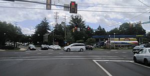
Center of Richboro at Almshouse Road (PA 332) and Second Street Pike (PA 232)
|
|
| Country | United States |
| State | Pennsylvania |
| County | Bucks |
| Township | Northampton |
| Area | |
| • Total | 4.41 sq mi (11.41 km2) |
| • Land | 4.38 sq mi (11.34 km2) |
| • Water | 0.03 sq mi (0.07 km2) |
| Elevation | 262 ft (80 m) |
| Population
(2020)
|
|
| • Total | 6,443 |
| • Density | 1,471.00/sq mi (568.02/km2) |
| Time zone | UTC-5 (EST) |
| • Summer (DST) | UTC-4 (EDT) |
| ZIP Code |
18954
|
| Area codes | 215, 267 and 445 |
| FIPS code | 42-64464 |
Richboro is a community in Northampton Township, Bucks County, Pennsylvania, United States. It is known as a census-designated place (CDP). A CDP is a special area that the government uses for counting people, but it's not an officially incorporated town or city.
In 2020, about 6,378 people lived in Richboro. It is a quiet, family-friendly area.
Contents
History of Richboro
Richboro has several important historical places. These buildings are very old and special. They are listed on the National Register of Historic Places. This means they are protected because of their history.
Some of these historic places include:
- Hampton Hill
- John Thompson House
- Twin Trees Farm
- Willow Mill Complex
These sites help us remember the past of Richboro.
Where is Richboro Located?
Richboro is located in Pennsylvania. Its exact spot on a map is 40.221658 degrees north and 75.006047 degrees west.
A big part of Tyler State Park is also in Richboro. This park offers many outdoor activities. It is a great place for nature lovers.
Size of Richboro
Richboro covers a total area of about 4.4 square miles (11.4 square kilometers). All of this area is land. There are no large lakes or rivers within its borders.
Who Lives in Richboro?
The number of people living in Richboro changes over time. Here is how the population has grown:
| Historical population | |||
|---|---|---|---|
| Census | Pop. | %± | |
| 1990 | 5,332 | — | |
| 2000 | 6,678 | 25.2% | |
| 2010 | 6,563 | −1.7% | |
| 2020 | 6,443 | −1.8% | |
In 2000, there were 6,678 people living here. Most of the people were White (97.09%). A small number were Asian (1.81%) or African American (0.36%).
Families and Homes
In 2000, there were 2,062 households in Richboro. A household is a group of people living together. Most households (83.9%) were married couples. About 45.4% of households had children under 18.
The average household had 3.20 people. The average family had 3.39 people.
Age Groups
Richboro has people of all ages. In 2000:
- 28.9% of people were under 18 years old.
- 9.7% of people were 65 years or older.
The average age in Richboro was 40 years old.
Education in Richboro
Richboro is part of the Council Rock School District. This school district also serves nearby towns. These towns include Holland and Churchville.
Students in Richboro attend schools within this district. The district provides education from elementary to high school.
See also
 In Spanish: Richboro para niños
 | James Van Der Zee |
 | Alma Thomas |
 | Ellis Wilson |
 | Margaret Taylor-Burroughs |


