
Pinckney's Treaty facts for kids
| Treaty of Friendship, Limits, and Navigation Between Spain and the United States | |
|---|---|

The treaty established the boundary between the United States and Spanish Florida at 31°N
|
|
| Context | Defined the border between the United States and Spanish Florida; guaranteed US navigation rights on the lower Mississippi River |
| Signed | 27 October 1795 |
| Location | San Lorenzo de El Escorial |
| Effective | August 2, 1796 |
| Negotiators |
|
| Parties | |
Pinckney's Treaty, also known as the Treaty of San Lorenzo or the Treaty of Madrid, was an important agreement signed on October 27, 1795. It was made between the United States and Spain.
This treaty set the official border between the United States and Spanish Florida. It also gave the United States important rights to use the Mississippi River for trade. This agreement helped end the first part of a long argument between the two countries over land in this area. This argument was called the West Florida Controversy.
Thomas Pinckney worked for the United States to create the treaty. Don Manuel de Godoy represented Spain. The treaty was approved by the United States Senate on March 7, 1796. Spain approved it on April 25, 1796. The treaty officially started on August 2, 1796.
Why the Treaty Was Needed
Setting the Borders of Florida
After the French and Indian War in 1763, Great Britain took control of Florida from Spain. Britain also got land east of the Mississippi River from France. Britain divided this land into two colonies: East Florida and West Florida.
In 1783, after the American Revolutionary War, Britain gave both East and West Florida back to Spain. However, the exact borders of West Florida were not clear. This led to disagreements.
The Border Dispute
When Britain first set up West Florida in 1763, its northern border was at 31 degrees north latitude. This is a line on a map. But in 1764, Britain moved the border further north to 32 degrees 28 minutes. This new line included more land, like the Natchez and Tombigbee areas.
When Spain got West Florida back, it claimed the border was at the northern line (32° 28′). But the United States said the land between the two lines (31° and 32° 28′) had always been British. So, the U.S. believed this land should belong to them.
Mississippi River Trade
In 1784, Spain closed the city of New Orleans to American traders. This was a big problem because American goods from the west traveled down the Mississippi River to New Orleans. From there, they would be shipped out to other places.
The Pinckney's Treaty helped solve this problem. New Orleans was reopened for American trade. Americans could also transfer their goods from one ship to another without paying extra fees. This was called the "right of deposit."
What the Treaty Said
Article II: Southern Border
The treaty clearly set the southern border of the United States with Spanish Florida. It started at the Mississippi River at the 31st parallel north. This was the original 1763 border line.
From there, the border went east to the middle of the Chattahoochee River. Then it followed the middle of the Chattahoochee River downstream to where it met the Flint River. From that point, it went straight east to the start of the St. Marys River. Finally, it followed the middle of the St. Marys River to the Atlantic Ocean.
Article III: Surveying the Line
The treaty said that a joint team of Spanish and American experts would work together. Their job was to survey, or measure, and mark the new border line.
Article IV: Western Border and River Use
The western border of the United States with Spanish Louisiana was set as the middle of the Mississippi River. This line went from the northern edge of the United States all the way south to the 31st degree north latitude.
Both Spanish people and U.S. citizens were given the right to travel freely on the entire length of the Mississippi River. This meant they could use the river from its source (where it begins) all the way to the ocean.
Article V: Native American Relations
The United States and Spain agreed not to encourage Native American tribes to fight. They also promised to help create good trade relationships with tribes on both sides of the new border. Before this, Spain had sometimes given weapons to local tribes.
This agreement also meant that the lands of the Chickasaw and Choctaw Nations of American Indians were now inside the new borders of the United States.
Articles VI and VII: Protecting Ships
Spain and the United States also agreed to protect each other's ships in their territories. They promised not to stop or seize each other's citizens or vessels.
What Happened Next
A team of surveyors, including Andrew Ellicott for the U.S., marked the new border line. One important marker is called "Ellicott's Stone".
The land that Spain gave up its claim to was later organized by the U.S. Congress. It became the Mississippi Territory in 1798. Natchez was its first capital city.
Historians believe this treaty was very important for the idea of American expansionism. This idea was later called "Manifest destiny". It meant the United States would grow and spread across the continent. Gaining control of the Natchez and Tombigbee areas was key to the U.S. becoming powerful in the Southwest.
Spain lost its power in the region because many Americans moved there. Very few Spaniards lived in these areas. Spain gave up the land because of bigger international politics, not just local problems. After losing Natchez, Spain's border was no longer safe, and it slowly lost more territory.
Later Border Changes
In 1800, Spain secretly gave Louisiana back to France in the Third Treaty of San Ildefonso. This included the vast land west of the Mississippi River and New Orleans. But again, the exact borders were not clear.
When France sold Louisiana to the United States in the Louisiana Purchase in 1803, a new argument started. This was the second part of the West Florida Controversy. The U.S. claimed that the part of West Florida between the Mississippi and Perdido Rivers was included in the Louisiana Purchase. Spain disagreed.
In 1810, American and British settlers in the region declared their own country, the Republic of West Florida. Its capital was St. Francisville. The United States quickly took over this area. It became part of the Territory of Orleans, which joined the U.S. as the state of Louisiana in 1812. The areas that were part of this republic are now called the "Florida Parishes" in Louisiana.
In 1812, the U.S. also took over the Mobile District of West Florida. This was the land between the Perdido and Pearl Rivers. The U.S. said it was part of the Louisiana Purchase. Spain still disagreed. The U.S. military, led by General James Wilkinson, occupied this area. Spain did not fight back. This land became part of the Mississippi Territory and later the Alabama Territory.
Finally, in 1819, the United States and Spain signed the Adams–Onís Treaty. In this treaty, Spain gave all of West Florida and East Florida to the United States.
Since the mid-1800s, the southern border set by Pinckney's Treaty has formed the state lines between:
- Florida and Georgia
- Florida and Alabama (between the Chattahoochee and Perdido Rivers)
- Louisiana and Mississippi (between the Pearl and Mississippi Rivers)
The line is not a state line between the Pearl and Perdido Rivers. This allows Mississippi and Alabama to have access to the Gulf of Mexico.
Images for kids
-
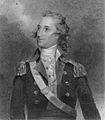
Thomas Pinckney was the U.S. negotiator.
-

Manuel Godoy represented Spain in the treaty talks.
-
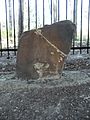
"Ellicott's Stone" is a boundary marker along the 31st parallel in northern Mobile County, Alabama.
-
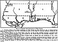
This map shows how the borders of British and Spanish West Florida changed from 1767 to 1819.

.jpg)


See also
 In Spanish: Tratado de San Lorenzo (1795) para niños Anglo-Spanish War (1796–1808)
