
Pearl River (Mississippi–Louisiana) facts for kids
Quick facts for kids Pearl River |
|
|---|---|

The Pearl River in Hinds County, MS
|
|
| Country | U.S. |
| Physical characteristics | |
| Main source | Neshoba County, Mississippi 400 feet (120 m) |
| River mouth | Lake Borgne |
| Length | 444 miles (715 km) |
| Basin features | |
| Basin size | 8,760 square miles (22,700 km2) |

The Pearl River is a long river in the southern United States. It flows through Mississippi and Louisiana. This river starts in Neshoba County, Mississippi where two creeks, Nanih Waiya and Tallahaga, join together. The Pearl River is about 444 miles long.
The lower part of the river forms a natural border between Mississippi and Louisiana. The river is home to many animals because it has large areas of swampy forests. These forests are filled with hardwood trees and cypress trees. Many animals live here, including sturgeon fish and black bears. The area where the river meets the sea has important marsh habitats. These marshes are like wetlands and are very important for nature in Louisiana. The capital city of Mississippi, Jackson, Mississippi, is located right on the Pearl River.
Contents
Exploring the Pearl River's Branches and Water Flow

.jpg)
The Pearl River has several smaller rivers and creeks that flow into it. These are called tributaries. Some important tributaries in the upper part of the river are the Yockanookany River and the Strong River. Further down, the Bogue Chitto River joins the Pearl River.
Years ago, some parts of these rivers and creeks were changed to make them straighter. For example, Tuscolameta Creek and Yockanookany River had canals built to make them flow more directly.
Northeast of Jackson, Mississippi, there is a large lake called the Ross Barnett Reservoir. This lake was created in 1962 by building a dam across the river. The amount of rain that falls in the river's area changes. The northern part gets about 52 inches of rain each year. South of Jackson, the river basin gets even more rain, sometimes 64 inches or more.
Near the town of Picayune, about 50 miles from where it meets the sea, the Pearl River splits into two main parts. The East Pearl River flows into Lake Borgne. The West Pearl River flows into an area called Rigolets, which also leads to Lake Borgne. Both parts of the river eventually reach the Gulf of Mexico. For about 115 miles, the Pearl River acts as the border between Mississippi and Louisiana.
Towns Along the Pearl River
Many towns and cities are located along the Pearl River. Some of them are even named after the river itself! Here are some of the towns you would find if you traveled down the river from north to south:
- Philadelphia, Mississippi
- Pearl River, Mississippi
- Carthage, Mississippi
- Jackson, Mississippi
- Flowood, Mississippi
- Pearl, Mississippi
- Georgetown, Mississippi
- Rockport, Mississippi
- Monticello, Mississippi
- Columbia, Mississippi
- Bogalusa, Louisiana
- Picayune, Mississippi
- Pearlington, Mississippi
- Pearl River, Louisiana
Boating and Changes to the Pearl River


For a long time, people have used the Pearl River for shipping goods. In the early 1800s, many boats used the river. The United States Army Corps of Engineers has worked on the river to help boats travel more easily.
In 1880, they planned a 5-foot deep channel on the West Pearl River. This project was stopped in 1922. Later, in 1910, a channel was dug from the East Pearl River into Lake Borgne, and this channel is still sometimes maintained. In 1935, another project was started on the West Pearl River. It included building a canal with three special gates called locks. These locks help boats move between different water levels.
However, in the 1970s, less commercial traffic used the river, so maintenance on these projects slowed down. In the 1950s, concrete barriers were built underwater to keep water levels steady for boats. These barriers made it hard for fish like the Gulf sturgeon to swim upstream to lay their eggs. In 2003, a rock ramp was built to help fish get over one of these barriers. Environmental groups want more work done to help the fish.
Building dams and canals can harm wetlands and the natural services they provide, like cleaning water. Sometimes, these structures are removed to let rivers flow more naturally. The Pascagoula River is a good example of a natural river in the South. It could be a model for how to help the Pearl River's natural floodplains recover.
How Hurricanes Affect the River
Hurricanes are natural events that have shaped rivers and their surrounding lands for thousands of years. For example, Hurricane Katrina in August 2005 caused big changes in the Pearl River. The storm moved a lot of dirt and plants, including whole cypress and oak trees. This debris blocked parts of the river channel.
Agencies worked to remove a lot of this debris. However, this kind of woody debris is actually a natural part of river ecosystems and wetlands. It provides important homes for animals like fish and turtles. So, removing it can sometimes have negative effects on the river's wildlife.
The Pearl River in Culture
The Pearl River has inspired people in different ways. A journalist and poet named Pearl Rivers chose her name after this river. Also, a country music band called Pearl River took its name from the river. In wrestling, a move used by Ahmed Johnson was called the Pearl River Plunge.
Images for kids
-
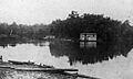
Floating saloons on the Pearl River. The "Blue Goose" (left) and "Freeman Saloon" (center), near Old Gainesville, Hancock County, Mississippi, 1907.
-
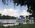
A Saturn V first stage is transported by the barge Pearl River down the East Pearl River on its way from Stennis Space Center, then named the National Space Technology Laboratories, to Florida for launch.
See also
 In Spanish: Río Pearl para niños
