Lake Borgne facts for kids
Quick facts for kids Lake Borgne |
|
|---|---|

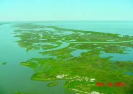
A strip of marsh separates the MRGO (left) from the lake (right)
|
|
| Location | Orleans / St. Bernard / St. Tammany parishes, Louisiana / Hancock County, Mississippi, United States |
| Coordinates | 30°01′41″N 89°37′03″W / 30.02806°N 89.61750°W |
| Type | lagoon |
| Primary inflows | MRGO and Mississippi River |
| Primary outflows | Gulf of Mexico |
| Catchment area | 38,000 km2 (15,000 sq mi) |
| Basin countries | United States |
| Surface area | 730 km2 (280 sq mi) |
| Average depth | 3 m (9.8 ft) |
| Settlements | New Orleans |
Lake Borgne (which means Lac Borgne in French) is a large body of water in southeastern Louisiana. It is connected to the Gulf of Mexico. Even though old maps show it as a lake surrounded by land, it has changed over time. Now, because of land wearing away, it acts more like an arm of the Gulf. Its name comes from the French word borgne, which means "one-eyed."
Contents
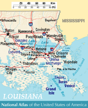
Exploring Lake Borgne's Location
In southern Louisiana, there are three big lakes: Maurepas, Pontchartrain, and Borgne. Together, these lakes cover more than half of the Pontchartrain Basin. A "basin" is like a giant bowl where all the water drains into one place.
A marshy area and Lake St. Catherine separate Lake Pontchartrain from Lake Borgne. The Rigolets and Chef Menteur Pass are two waterways that connect Lake Pontchartrain to Lake Borgne.
How Lake Borgne Changed
Over many years, coastal erosion (the wearing away of land by water) has turned Lake Borgne into a lagoon. A lagoon is a shallow body of water separated from a larger body of water by a barrier, like a sandbar or coral reef. In this case, the land that once separated Lake Borgne from the Gulf of Mexico has disappeared.
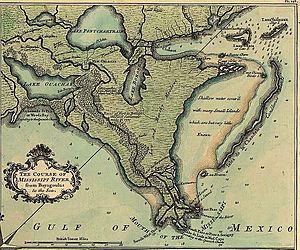
Maps from the early 1700s show Lake Borgne as a true lake. It was mostly separated from the Gulf by a lot of wetlands, which are areas of land covered by water. These wetlands have since vanished. In 1902, there was a court case about oyster beds between Louisiana and Mississippi. Mississippi argued that Lake Borgne might not have even existed as a separate lake when Louisiana became a state. This shows how much the area has changed.
Wetlands Around the Lake
The area around Lake Borgne has many wetlands. These include different types of marshes: fresh, intermediate, brackish, and saline. There are also cypress swamps. Since 1932, over 66,000 acres of marsh in the Pontchartrain Basin have turned into open water. This is more than 22% of the marsh that was there in 1932.
The main reasons for this wetland loss are human activities and natural processes that started a long time ago. The Mississippi River used to build up new land with its delta, but natural changes in the river stopped this process.
Protecting the Area
After Hurricane Katrina caused a lot of damage in 2005, the Army Corps of Engineers built a huge barrier. This barrier, called the IHNC Lake Borgne Surge Barrier, is 1.8 miles long. It cost about $1.1 billion to build.
This barrier helps protect southeast Louisiana from storm surges. A storm surge is when a storm pushes a lot of water onto the land. The barrier was first used in 2012 during Hurricane Isaac. It was fully finished in 2013.
Lake Borgne's Environment
The levees (raised banks) along the Mississippi River greatly reduce how much fresh water, mud, and nutrients flow into the Pontchartrain basin. This lack of fresh water causes a big problem: increased salinity. Salinity means how much salt is in the water.
The building of the Mississippi River Gulf Outlet (MRGO) also made things worse. This canal cut through natural land barriers, letting salty ocean water push further into the basin. Also, the sea level is slowly rising, which allows even more salty water into the wetlands. Because of this, the average saltiness of the water has gone up since the MRGO and other canals were built. Luckily, in recent years, the salt levels have become more stable. However, the higher saltiness has harmed the wetlands, especially freshwater marshes and swamps.
Protecting the Land Bridges
Since 1932, about 24% of the land bridge near Lake Borgne has been lost. This is due to the shoreline moving back and fast changes in water levels from tides. The rate of loss is increasing. During the same time, 17% of the land bridge near Lake Maurepas disappeared. This was due to the ground sinking and sudden increases in lake saltiness.
These "land bridges" are very important. They stop salty water and strong tidal currents from pushing further into the middle and upper parts of the basin. If these natural barriers are not saved, the land loss around Lakes Pontchartrain and Maurepas will get much worse. Many marshes in the basin are at risk of disappearing quickly if they are not protected soon.
See also
 In Spanish: Lago Borgne para niños
 | Toni Morrison |
 | Barack Obama |
 | Martin Luther King Jr. |
 | Ralph Bunche |


