Hancock County, Mississippi facts for kids
Quick facts for kids
Hancock County
|
|
|---|---|

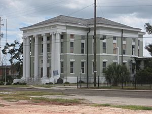
Hancock County courthouse in Bay St. Louis
|
|

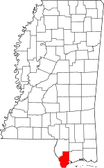
Location within the U.S. state of Mississippi
|
|
 Mississippi's location within the U.S. |
|
| Country | |
| State | |
| Founded | 1812 |
| Named for | John Hancock |
| Seat | Bay St. Louis |
| Largest city | Bay St. Louis |
| Area | |
| • Total | 553 sq mi (1,430 km2) |
| • Land | 474 sq mi (1,230 km2) |
| • Water | 79 sq mi (200 km2) 14% |
| Population
(2020)
|
|
| • Total | 46,053 |
| • Estimate
(2023)
|
46,159 |
| • Density | 83.28/sq mi (32.154/km2) |
| Time zone | UTC−6 (Central) |
| • Summer (DST) | UTC−5 (CDT) |
| Congressional district | 4th |
Hancock County is the southernmost county in the state of Mississippi. It is named after John Hancock, one of the Founding Fathers of the United States. In 2020, about 46,053 people lived there.
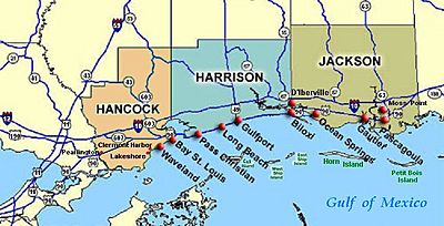
The main town, or county seat, is Bay St. Louis. Hancock County is part of the larger Gulfport–Biloxi area. It sits right on the Gulf of Mexico and borders the state of Louisiana. This county is also home to the John C. Stennis Space Center, which is NASA's biggest rocket engine testing site. On August 29, 2005, Hurricane Katrina caused huge damage here. A massive storm surge flooded the area, leading to terrible destruction.
Contents
History of Hancock County
Long ago, Native American tribes lived in this part of Mississippi. Then, French settlers and traders arrived. They brought people from Africa to work, and over time, a group of free people of color, known as Creoles, grew in the area.
In the 1830s, the United States government moved many Native American tribes from their lands. After this, more American settlers came to Hancock County. However, the area still kept some of its French and African Catholic traditions. Being on the Gulf Coast, the county often experienced hurricanes. People living there learned how to deal with these strong storms.
In 2005, Hurricane Katrina hit Hancock County directly. The storm caused some of the worst damage seen anywhere. Along the entire 7-mile (11 km) beachfront, almost every building was destroyed. The first block of homes near the beach was also completely wiped out.
The storm surge was very high, happening during a full moon. It flooded homes up to 10 miles (16 km) inland. All the rivers and waterways overflowed. Highway 603 south of Interstate 10 was completely underwater. The Highway 90 bridge in Bay St. Louis looked like a pile of fallen dominoes.
Many houses were lifted off their foundations by the water. In towns like Waveland and Bay St. Louis, some homes ended up on railroad tracks or in the middle of streets. Towns such as Pearlington, Waveland, Bay St. Louis, Diamondhead, and Kiln were severely damaged.
Helping After Hurricane Katrina
After Hurricane Katrina, a group called the "Rainbow Family" came to Hancock County. From September to December 2005, they set up the "New Waveland Cafe and Clinic". This was in the parking lot of a store on Highway 90.
The café gave out free hot meals three times a day. The clinic had volunteer doctors and nurses from all over the U.S. They helped over 5,000 patients for free and gave out free medicines. Many groups donated medicines and supplies, with International Aid sending the most. This was the first time the Rainbow Family had run a disaster relief center. The Bastrop Christian Outreach Center also helped them.
Local churches were very important for recovery in Bay St. Louis, Waveland, and Diamondhead. Some churches offered shelter, food, clothes, and cleaning supplies. They also served as places where donations could be dropped off and given to those who needed help. Other groups that helped in Hancock County included Samaritan's Purse, Southern Baptist Convention Disaster Relief, Red Cross, Rotary International, and the Salvation Army.
Businesses worked hard to reopen quickly. The Wal-Mart in Waveland operated out of a tent for three months after the storm. Diamondhead Discount Drug reopened in just two days, even though the owner's store and home were badly damaged. Other businesses like Dairy Queen and Subway gave away their food before it spoiled, helping to feed survivors.
Geography of Hancock County
Hancock County covers a total area of 553 square miles (1,432 km²). Out of this, 474 square miles (1,228 km²) is land, and 79 square miles (205 km²) is water. This means about 14% of the county is water.
Main Roads in Hancock County
 Interstate 10
 U.S. Highway 90
 Mississippi Highway 43
 Mississippi Highway 53
 Mississippi Highway 603
 Mississippi Highway 607
Neighboring Counties and Parishes
- Pearl River County (to the north)
- Harrison County (to the east)
- St. Bernard Parish, Louisiana (to the south)
- St. Tammany Parish, Louisiana (to the west)
People in Hancock County
| Historical population | |||
|---|---|---|---|
| Census | Pop. | %± | |
| 1820 | 1,594 | — | |
| 1830 | 1,962 | 23.1% | |
| 1840 | 3,367 | 71.6% | |
| 1850 | 3,672 | 9.1% | |
| 1860 | 3,139 | −14.5% | |
| 1870 | 4,239 | 35.0% | |
| 1880 | 6,439 | 51.9% | |
| 1890 | 8,318 | 29.2% | |
| 1900 | 11,886 | 42.9% | |
| 1910 | 11,207 | −5.7% | |
| 1920 | 10,380 | −7.4% | |
| 1930 | 11,415 | 10.0% | |
| 1940 | 11,328 | −0.8% | |
| 1950 | 11,891 | 5.0% | |
| 1960 | 14,039 | 18.1% | |
| 1970 | 17,387 | 23.8% | |
| 1980 | 24,537 | 41.1% | |
| 1990 | 31,760 | 29.4% | |
| 2000 | 42,967 | 35.3% | |
| 2010 | 43,929 | 2.2% | |
| 2020 | 46,053 | 4.8% | |
| 2023 (est.) | 46,159 | 5.1% | |
| U.S. Decennial Census 1790-1960 1900-1990 1990-2000 2010-2013 2019 |
|||
| Race | Num. | Perc. |
|---|---|---|
| White (non-Hispanic) | 37,341 | 81.08% |
| Black or African American (non-Hispanic) | 3,911 | 8.49% |
| Native American | 244 | 0.53% |
| Asian | 424 | 0.92% |
| Pacific Islander | 9 | 0.02% |
| Other/Mixed | 2,206 | 4.79% |
| Hispanic or Latino | 1,918 | 4.16% |
In 2020, there were 46,053 people living in Hancock County. These people lived in 20,036 households, and 13,081 of these were families.
Hancock is special because it's the only county in Mississippi where Roman Catholics are a larger group than Baptists. This is because of the county's French history and its closeness to Southern Louisiana, which has many Catholic residents.
Communities in Hancock County
Cities
- Bay St. Louis (This is the county seat, where the main government offices are)
- Diamondhead
- Waveland
Census-Designated Places
These are areas that are like towns but are not officially incorporated as cities.
Unincorporated Communities
These are smaller communities that are not part of any city or census-designated place.
- Ansley
- Clermont Harbor
- Lakeshore
- Leetown
- Napoleon
- Necaise
- Shoreline Park (This used to be a census-designated place)
Ghost Towns
These are towns that no longer exist or are mostly deserted.
- Gainesville
- Logtown
Education in Hancock County
Children in Hancock County attend schools in these districts:
- Bay St. Louis School District
- Hancock County School District
- Picayune School District
See also
 In Spanish: Condado de Hancock (Misisipi) para niños
 | Emma Amos |
 | Edward Mitchell Bannister |
 | Larry D. Alexander |
 | Ernie Barnes |


