Kiln, Mississippi facts for kids
Quick facts for kids
Kiln, Mississippi
|
|
|---|---|
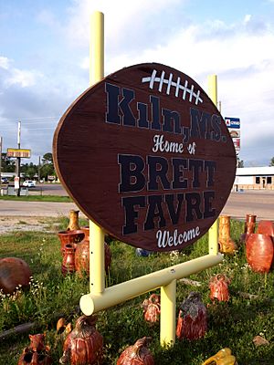
A football-shaped city welcome sign in honor of notable former resident Brett Favre
|
|
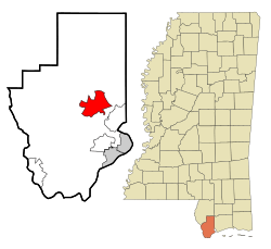
Location of Kiln, Mississippi
|
|
| Country | United States |
| State | Mississippi |
| County | Hancock |
| Area | |
| • Total | 13.42 sq mi (34.75 km2) |
| • Land | 13.16 sq mi (34.10 km2) |
| • Water | 0.25 sq mi (0.65 km2) |
| Elevation | 23 ft (7 m) |
| Population
(2020)
|
|
| • Total | 2,224 |
| • Density | 168.95/sq mi (65.23/km2) |
| Time zone | UTC-6 (Central (CST)) |
| • Summer (DST) | UTC-5 (CDT) |
| ZIP code |
39556
|
| Area code(s) | 228 |
| FIPS code | 28-37600 |
| GNIS feature ID | 0672123 |
Kiln (pronounced "Kill") is a small community in Hancock County, Mississippi, United States. It is a "census-designated place" (CDP), which means it's a community that is counted for the census but isn't officially a city or town. Kiln is located about 50 miles northeast of New Orleans, Louisiana. It is part of the larger Gulfport-Biloxi metropolitan area. In 2020, about 2,224 people lived there.
History of Kiln
Early Settlers and Land Claims
Long ago, the land where Kiln is now was home to Choctaw and Muscogee Indians. They lived along the Jourdan River, which flows into the Bay of Saint Louis. These tribes hunted, fished, and trapped on the land.
In 1682, a French explorer named René-Robert Cavelier, Sieur de La Salle claimed this region for France. He named it "Louisiana" after King Louis XIV. The Mississippi Gulf Coast became part of this French territory.
Later, French settlers, many from Canada, moved to the Kiln area. They were mostly hunters and trappers. The first known white settlers were Jean Baptiste Nicaize and his family, who likely moved there around 1800. The Jourdan River was named after Noel Jourdan, an early settler who later became a representative for Hancock County. Over time, the Native American tribes moved away from the area.
The land changed hands several times. In 1763, France gave Louisiana east of the Mississippi River to Great Britain. This area became part of British West Florida. In 1783, Great Britain gave it to Spain, and it became part of Spanish West Florida. The United States claimed the area in 1803 as part of the Louisiana Purchase, but Spain disagreed. Eventually, in 1813, the United States took control of the area.
Timber Industry and "The Kiln" Name
Kiln got its name from the many "kilns" (special ovens) that were once in the area. These kilns were used by the timber industry to make products like tar. Tar was shipped to New Orleans and used to seal ships. Tar kilns had been in Hancock County since the British ruled the area.
By the 1880s, people started calling the community "Kiln." Today, locals often say "the Kiln," and the "n" sound is silent.
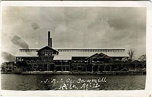
The sawmill business began around the time of the American Civil War. Samuel L. Favre built a sawmill on the Jourdan River in 1859. His house, built in 1859, is now considered the oldest house in Kiln. Other sawmills and shipyards also opened along the Jourdan River and Bayou Talla. These businesses helped the booming yellow pine timber industry.
During the early 1900s, Kiln was a very busy place. In 1908, the W. W. Carre Company bought a mill and built a railroad track to transport lumber. After a fire in 1912, the Edward Hines Lumber Company took over and built a new, much larger mill in 1914.
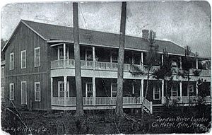
To support all the workers, about 200 houses were built. The town also had a company store, a 50-room hotel with a restaurant, a small hospital, a movie theater, and a drug store. There was also a secondary school, churches, and even a semi-pro baseball team. For a while, Kiln was one of the busiest towns between Hattiesburg and New Orleans.
The Great Depression and Moonshine
The Great Depression hit Kiln very hard. The lumber supply also ran out. In 1930, the big mill closed down. Kiln lost its hotel, hospital, and railroad. The town even lost its electricity. By the mid-1930s, Kiln became almost a ghost town with no major industries. Much of the land that had been cleared for logging grew back into a forest.
Many residents who stayed in Kiln made a living by making illegal whiskey. This became a big business after Mississippi banned alcohol in 1908. Because of its high-quality and easy-to-find moonshine, Kiln became known as the "Moonshine Capital of the World." In the late 1920s, there were at least 50 moonshine stills operating in Kiln. Mississippi's alcohol ban wasn't lifted until 1966.
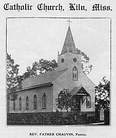
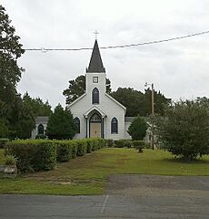
Despite these tough times, some old buildings still stand today, like the Annunciation Catholic Church and the original post office.
Growth and Hurricane Katrina
Towards the end of the 20th century, Kiln's population started to grow again. Between 1990 and 2000, the population increased by almost 62%. This growth was largely due to the new casino industry on the Mississippi Gulf Coast. In 1990, Hancock County was the first county in Mississippi to allow dockside gambling.
Casinos opened in nearby areas, bringing new tourists and jobs. This led to more people moving to towns like Kiln. Kiln became the fastest-growing area in Hancock County. This growth brought new businesses, a new post office, two new schools, and a new library to the town.
On August 29, 2005, Hurricane Katrina hit the Mississippi Gulf Coast. Water flooded into the Bay of Saint Louis, and low-lying areas along the Jourdan River, including Kiln, flooded early. Kiln saw at least 30 feet of floodwater. Many homes were badly damaged or destroyed. However, Kiln was not hit as hard as some other towns and became an important place for rebuilding efforts in nearby Bay Saint Louis and Waveland.
Geography
As mentioned, locals often call the town "the Kiln," with the "n" being silent. The Jourdan River forms the southern border of the town. Other important waterways include Bayou Coco, Bayou Talla, and Bayou La Terre.
According to the United States Census Bureau, the Kiln CDP covers a total area of 34.7 square kilometers (about 13.4 square miles). Most of this area is land, with a small part being water.
Main Roads
Mississippi Highway 43 and 603 are the main roads through Kiln. They lead south together for about 4 miles to Interstate 10. Highway 43 goes northwest to Picayune, and Highway 603 goes north to Necaise. From Kiln, New Orleans is about 57 miles southwest, and Biloxi is about 39 miles east.
Nearby Places
- Bay Saint Louis (13 miles south)
- Diamondhead (7 miles southeast)
- Shoreline Park (8 miles south)
- Waveland (11 miles south)
- Picayune, Mississippi (17 miles southeast)
Climate
| Climate data for Kiln, Mississippi | |||||||||||||
|---|---|---|---|---|---|---|---|---|---|---|---|---|---|
| Month | Jan | Feb | Mar | Apr | May | Jun | Jul | Aug | Sep | Oct | Nov | Dec | Year |
| Record high °F (°C) | 83 (28) |
85 (29) |
88 (31) |
94 (34) |
98 (37) |
101 (38) |
104 (40) |
104 (40) |
103 (39) |
97 (36) |
88 (31) |
83 (28) |
104 (40) |
| Mean daily maximum °F (°C) | 59 (15) |
63 (17) |
69 (21) |
75 (24) |
82 (28) |
87 (31) |
89 (32) |
89 (32) |
85 (29) |
77 (25) |
69 (21) |
61 (16) |
75 (24) |
| Mean daily minimum °F (°C) | 39 (4) |
42 (6) |
47 (8) |
53 (12) |
62 (17) |
69 (21) |
71 (22) |
71 (22) |
66 (19) |
55 (13) |
46 (8) |
40 (4) |
55 (13) |
| Record low °F (°C) | 5 (−15) |
9 (−13) |
20 (−7) |
28 (−2) |
42 (6) |
48 (9) |
62 (17) |
58 (14) |
44 (7) |
31 (−1) |
24 (−4) |
10 (−12) |
5 (−15) |
| Average precipitation inches (mm) | 5.51 (140) |
5.23 (133) |
5.36 (136) |
4.85 (123) |
4.69 (119) |
5.68 (144) |
6.89 (175) |
6.3 (160) |
5.05 (128) |
3.75 (95) |
4.86 (123) |
4.57 (116) |
62.74 (1,594) |
Population and People
| Historical population | |||
|---|---|---|---|
| Census | Pop. | %± | |
| 1990 | 1,262 | — | |
| 2000 | 2,040 | 61.6% | |
| 2010 | 2,238 | 9.7% | |
| 2020 | 2,224 | −0.6% | |
| U.S. Census data | |||
2020 Census Information
The 2020 United States census counted 2,224 people living in Kiln. There were 1,023 households and 611 families.
| Race | Num. | Perc. |
|---|---|---|
| White (non-Hispanic) | 1,913 | 86.02% |
| Black or African American (non-Hispanic) | 69 | 3.1% |
| Native American | 14 | 0.63% |
| Asian | 21 | 0.94% |
| Other/Mixed | 126 | 5.67% |
| Hispanic or Latino | 81 | 3.64% |
2010 Census Information
In 2010, there were 2,238 people, 847 households, and 597 families in Kiln. Most people (92.7%) were White, 3.4% were African American, and 0.6% were Native American. About 3.7% of the population was Hispanic or Latino.
About 27.4% of households had children under 18. The average household had 2.59 people. The median age in Kiln was 42.3 years old.
Education
Kiln is part of the Hancock County School District. The town has a vocational school, two elementary schools, a middle school, and a high school. All of Hancock County is also served by Pearl River Community College.
Schools in Kiln
- Hancock County Vocational Center
- East Hancock Elementary School
- Hancock North Central Elementary School
- West Hancock Elementary School
- Hancock Middle School
- Hancock High School
Famous People from Kiln
Kiln is home to some well-known individuals, especially in sports and entertainment:
- Dick Arrington – A former professional football player.
- Brett Favre – A famous professional football player and a member of the Pro Football Hall of Fame.
- Deanna Favre – The founder of the Deanna Favre Hope Foundation.
- Leland Mitchell – A professional basketball player.
- Philip Moran – A member of the Mississippi House of Representatives.
- Serabee – A singer-songwriter.
See also
 In Spanish: Kiln (Misisipi) para niños
 | Charles R. Drew |
 | Benjamin Banneker |
 | Jane C. Wright |
 | Roger Arliner Young |


