Rigolets facts for kids
Quick facts for kids Rigolets |
|
|---|---|

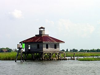
The abandoned West Rigolets Light in 2004. It was destroyed by Hurricane Katrina in 2005.
|
|

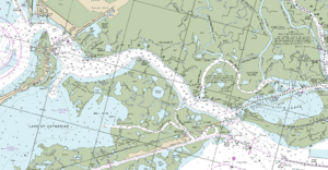
NOAA Coast Survey nautical map 2016
|
|
| Country | United States |
| State | Louisiana |
| Physical characteristics | |
| Main source | Lake Pontchartrain 30°10′40″N 89°44′40″W / 30.177778°N 89.744444°W |
| River mouth | Lake Borgne 30°09′16″N 89°37′31″W / 30.154444°N 89.625278°W |
| Length | 8 mi (13 km) |
| Basin features | |
| Tributaries |
|
The Rigolets is a deep, narrow waterway, about 12.9 kilometers (8 miles) long, located in Louisiana, USA. The name "Rigolets" comes from the French word rigole, which means "trench" or "gutter." People in the area now say it like "RIG-uh-leez."
This waterway starts near Lake Pontchartrain and flows east towards Lake Borgne. Lake Borgne is a large bay that connects to the Gulf of Mexico. The Rigolets, along with another nearby waterway called Chef Menteur Pass, links Lake Pontchartrain and Lake St. Catherine to Lake Borgne and the Gulf. It also forms the border between New Orleans and St. Tammany Parish.
Contents
The Rigolets: A Tidal Waterway
The Rigolets is a special type of waterway called a tidal pass. This means it helps bring salty water from the Gulf of Mexico into Lake Pontchartrain. The strong movement of the tides has even created a deep hole in the lake where the Rigolets begins.
Because the Rigolets is a direct path for Gulf storms to reach the New Orleans area, there have been ideas to build large floodgates. These gates would help protect the city from powerful storm surges, especially after big hurricanes hit in the early 2000s.
Fort Pike: Protecting the Pass
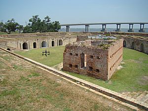
After the War of 1812, the United States built a fort called Fort Pike. Its main job was to guard the Rigolets and control who could pass through. However, by 1890, the fort was no longer needed for defense, so it was left empty.
Bridges Over the Rigolets
Two bridges cross the Rigolets. One is for cars and is part of U.S. Route 90. This bridge is located just north of Fort Pike. In August 2005, Hurricane Katrina damaged it, and it needed a lot of repairs to be safe again.
Farther south, a railroad bridge crosses the Rigolets. This bridge is used by the CSX Railroad and is very long, about 1,388 meters (4,555 feet). Hurricane Katrina also caused damage to this bridge, shifting parts of it and destroying some of its wooden sections.
See also
 In Spanish: Estrecho de Rigoleto para niños
 | Madam C. J. Walker |
 | Janet Emerson Bashen |
 | Annie Turnbo Malone |
 | Maggie L. Walker |


