Sawmill Pass facts for kids
Quick facts for kids Sawmill Pass |
|
|---|---|

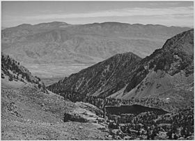
View of the Owens Valley from Sawmill Pass, ca. 1936
|
|
| Elevation | 11,309 ft (3,447 m) |
| Traversed by | Sawmill Pass Trail |
| Location | Inyo and Fresno Counties, California |
| Range | Sierra Nevada |
| Coordinates | 36°52′59″N 118°21′52″W / 36.88306°N 118.36444°W |
Sawmill Pass is a high mountain pass located in the beautiful Sierra Nevada mountains of California. It sits at an elevation of 11,309 feet (about 3,447 meters) above sea level, making it a challenging but rewarding destination for hikers and adventurers. This pass marks the border between the Inyo National Forest (which includes the John Muir Wilderness) to the east and Kings Canyon National Park to the west.
Contents
What is a Mountain Pass?
A mountain pass is like a natural gateway through a mountain range. It's usually the lowest or easiest path to cross from one side of the mountains to the other. For centuries, people have used passes for travel, trade, and exploration. Today, many mountain passes, like Sawmill Pass, are popular for hiking and enjoying nature.
Where is Sawmill Pass Located?
Sawmill Pass is found in the southern part of the Sierra Nevada mountain range. This famous mountain range stretches along the eastern side of California. The pass itself is right on the edge of two different counties: Inyo County and Fresno County.
Natural Surroundings
To the east of Sawmill Pass, you'll find the vast Inyo National Forest. This forest is home to the John Muir Wilderness, a protected area where nature is preserved in its wild state. To the west, the pass connects to Kings Canyon National Park, known for its deep canyons, towering trees, and stunning landscapes.
Exploring the Trails
Sawmill Pass is primarily reached by the Sawmill Pass Trail. This trail offers different experiences depending on which direction you approach it from.
The Eastern Approach
If you start from the east, near the Owens Valley floor, the Sawmill Pass Trail is known for being very steep and tough. Hikers climbing from this side gain about 6,700 feet (about 2,042 meters) in elevation. It's a strenuous climb, but it offers incredible views of the valley below as you ascend.
Connecting to Famous Trails
Once you reach the western side of Sawmill Pass, you'll find yourself in the high country of the Sierra Nevada. Here, the Sawmill Pass Trail connects with two very famous long-distance hiking routes: the John Muir Trail and the Pacific Crest Trail. These trails are popular with backpackers who spend weeks or even months exploring the wilderness. The connection happens along Woods Creek, a beautiful area within the mountains.
 | Emma Amos |
 | Edward Mitchell Bannister |
 | Larry D. Alexander |
 | Ernie Barnes |

