Mississippi River–Gulf Outlet Canal facts for kids
The Mississippi River–Gulf Outlet Canal (MRGO) was a large, man-made channel, about 76 miles (122 km) long. It was built by the United States Army Corps of Engineers in the mid-1900s. Its main purpose was to give ships a shorter path from the Gulf of Mexico to the port of New Orleans.
However, in 2005, the MRGO played a big role in making Hurricane Katrina's storm surge much worse. This led to major flooding and damage in the Greater New Orleans region. After the hurricane, the canal was closed to ships. A huge storm surge barrier was built in 2009 to protect the area from future storms.
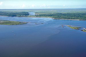
The MRGO started near New Orleans East and went southeast through wetlands in St. Bernard Parish, close to Lake Borgne, all the way to the Gulf of Mexico. Many people criticized the canal because it harmed the environment. It allowed saltwater to flow into freshwater areas, caused wetlands to disappear, and made storm surges more powerful. Because of these problems, the MRGO was officially closed in 2009.
Contents
History of the MRGO Canal
The idea for the MRGO canal first came up in the early 1900s. The Port of New Orleans wanted a quicker way for large ships to reach the Gulf of Mexico. At the time, ships had to travel a long, winding path down the Mississippi River. Other ports, like the Port of Houston, had built shorter channels, giving them an advantage.
New Orleans tried to solve this problem in 1923 with the Industrial Canal. This canal connected the Mississippi River to Lake Pontchartrain. But as ships got bigger, the locks on the Industrial Canal became too small. So, in the 1950s, the MRGO was proposed as a way for these larger ships to reach the port. The United States Congress approved the project in 1956, and the canal was finished in 1968.
Over time, the land around the canal eroded very quickly. By 2005, the MRGO was up to four times wider than when it was first built. It started at about 650 feet (198 meters) wide but grew to 3,000 feet (914 meters) wide in some places.
Why the MRGO Didn't Work Out
When the MRGO was completed in 1965, the Port of New Orleans planned to move most of its shipping activities to the new canal. This big project was called Centroport U.S.A.. However, the plan never received enough money and was eventually stopped in the mid-1980s. Only a few parts of the Centroport plan were ever built.
After the Centroport project was abandoned, the Port of New Orleans focused on improving its facilities along the Mississippi River. As a result, fewer and fewer ships used the MRGO. This led to many people criticizing the canal.
For example, in 1997, a group called the Competitive Enterprise Institute said the canal was not worth the cost. They pointed out that the promised economic growth in St. Bernard Parish had not happened. They also noted that the canal cost over $8 million each year to maintain, but it was used by less than two large container ships a day. The canal only saved ships about 37 miles (60 km) of travel.
Even before Hurricane Katrina, environmental groups and people living in St. Bernard Parish wanted the canal closed. They believed it was causing too much environmental damage.
MRGO's Role in Hurricane Katrina
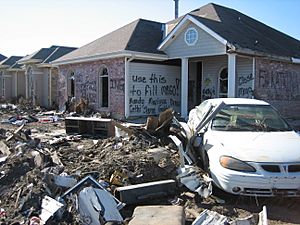
After Hurricane Katrina hit in 2005, criticism of the MRGO grew much stronger. Engineers found that the canal played a major role in the failure of the levees and floodwalls that protected New Orleans. Many people started calling the MRGO a "Hurricane Highway" because it seemed to make the storm surge worse.
During Katrina, levees along the MRGO and the Intracoastal Waterway broke in about 20 places. This directly flooded most of St. Bernard Parish and New Orleans East. The storm surge from the MRGO is also thought to have caused three floodwalls along the Industrial Canal to break.
Just three months before Katrina, a storm surge expert named Hassan Mashriqui called the MRGO a "critical flaw" in the area's hurricane defenses. He said it was like a "Trojan Horse" that could increase storm surges by 20 to 40 percent. After the storm, studies showed that the canal did make the initial surge 20 percent stronger. It also raised the height of the water by about three feet and increased the water's speed. This "funnel effect" likely caused the erosion that weakened the levees and floodwalls. Mashriqui believed that "Without MRGO, the flooding would have been much less."
Hurricane Katrina also filled the MRGO with sand and mud, making it impossible for large ships to use. Officials in St. Bernard Parish immediately said they did not want it reopened.
Closing the MRGO Canal
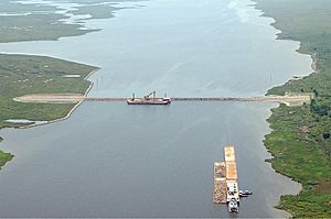
In May 2007, the United States Army Corps of Engineers announced that the MRGO would be closed to all ship traffic. They decided to build an earthen dam across the canal near Bayou La Loutre. This location was chosen because it would help restore the natural ridge that once protected the wetlands from the Gulf of Mexico.
Construction of the closure structure began in late 2008 and was finished in July 2009.
The Army Corps of Engineers also created a plan to restore the wetlands and water bodies damaged by the MRGO. This plan included:
- Bringing freshwater back into the area.
- Restoring thousands of acres of different types of marsh and cypress swamp.
- Protecting many miles of shoreline along Lake Borgne and the Biloxi Marsh.
However, this restoration plan, which would have cost about $2.9 billion, was never fully put into action. The U.S. Army Corps of Engineers and the State of Louisiana could not agree on who should pay for it.
The Surge Barrier
Closer to New Orleans, a very strong surge barrier was built. This barrier is 1.8 miles (2.9 km) long and cost over $1 billion. It closes off the narrow part of the "funnel" created by the MRGO and the Intracoastal Waterway. This prevents future storm surges from entering the inner harbor of the Industrial Canal and Intracoastal Waterway.
Two gates were built into the barrier, one at Bayou Bienvenue and another across the Intracoastal Waterway. These gates allow barges and other small commercial boats to pass through during normal weather. This barrier is the largest of its kind in the United States. It is designed to protect against storm surges up to 28 feet (8.5 meters) high. It was completed in 2011 and is a much more significant protection than the smaller closure structure at Bayou La Loutre.
 | George Robert Carruthers |
 | Patricia Bath |
 | Jan Ernst Matzeliger |
 | Alexander Miles |


