Industrial Canal facts for kids
Quick facts for kids Inner Harbor Navigation CanalIndustrial Canal |
|
|---|---|
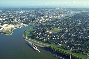
The Industrial Canal from the river to the lake. The Mississippi is at lower left and Lake Pontchartrain is at top in the distance. View is to the northwest. Picture taken before August 29, 2005.
|
|
| Specifications | |
| Locks | 1 (Industrial Canal Lock) |
| Status | Open |
| History | |
| Date of act | 1914 |
| Construction began | 6 June 1918 |
| Date of first use | 5 May 1923 |
The Industrial Canal is a 5.5-mile (9 km) waterway in New Orleans, Louisiana, United States. Its official name is the Inner Harbor Navigation Canal (IHNC). However, most people in New Orleans call it the "Industrial Canal."
This important canal connects the mighty Mississippi River to Lake Pontchartrain. It acts like a boundary, separating parts of New Orleans. For example, it divides New Orleans East from the rest of the city. It also separates the Lower Ninth Ward from the Upper 9th Ward.
About half of the canal's path is shared with two other waterways. These are the Gulf Intracoastal Waterway and the Mississippi River–Gulf Outlet Canal (MRGO). The entire canal runs through the 9th Ward of the city.
Contents
History of the Industrial Canal
People in New Orleans dreamed of a shipping canal connecting the Mississippi River to Lake Pontchartrain a long time ago. This idea goes back to when Spain controlled Louisiana (1763–1803). An early canal, the Carondelet Canal, connected the back of the French Quarter to the lake. But it couldn't reach the river because the river and lake had different water levels. Engineers knew that special canal locks would be needed to make it work.
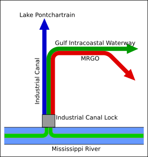
This simple map shows how the southern part of the Industrial Canal is also used by the Gulf Intracoastal Waterway and the Mississippi River–Gulf Outlet Canal (MRGO).
In July 1914, the government of Louisiana gave permission to the Port of New Orleans to build a deep-water shipping canal. This canal would connect the river and the lake. A study was done to figure out the best way to build it. One main reason for the canal was to help shipping after the Panama Canal was built. It also aimed to compete with railroads by making water transport better.
Engineers looked at five possible places for the canal. They decided that the best spot was near Press Street. This location could handle large ships.
In 1917, the Port bought land that used to belong to the Ursuline Convent. This land was chosen for the canal's locks and its path. Many buildings were torn down to make space for the canal. This included homes and the old Ursuline Convent.
Building the Canal
Digging of the canal started on June 6, 1918. The part from the lake to the lock near the river was built to be 30 feet (9 meters) deep. It was 300 feet (90 meters) wide at the top and at least 150 feet (45 meters) wide at the bottom.
The original lock system had five gates. It was 74 feet (23 meters) wide and 50 feet (15 meters) deep. This lock could handle a 20-foot (6-meter) difference in water levels between the river and the lake.
The canal officially opened on May 5, 1923. The governor of Louisiana, John M. Parker, led the opening ceremony. The whole project cost 19 million dollars.
The canal was first 5.3 miles (8.5 km) long. It became 5.5 miles (8.9 km) long later when the lakeshore was extended.
After the canal opened, docks were added along its sides. This made it a busy harbor and industrial area. It also served as a way for ships to pass through. In the 1930s, the Gulf Intracoastal Waterway (GIWW) opened. The Industrial Canal then became a key link for the GIWW.
During World War II, the Intracoastal Waterway was changed. A new part was dug that joined the Industrial Canal in the middle. In 1944, the government took over running the Industrial Canal lock. They also took care of the southern part of the canal.
In the 1960s, the area where the Industrial Canal and Intracoastal Waterway met was made bigger. This was because people expected a lot more ship traffic. This traffic was supposed to come from the new Mississippi River–Gulf Outlet Canal, which opened in 1965. However, the expected increase in traffic didn't happen.
Hurricane Damage to the Canal
In 1965, Hurricane Betsy caused a break in the canal's levees. This led to flooding in the Lower 9th Ward. After that, strong concrete floodwalls were built to replace the levees.
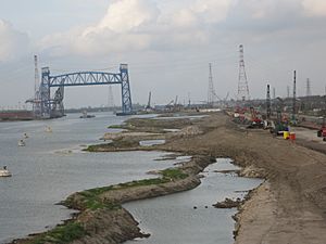
In 2005, Hurricane Katrina hit. The storm surge was pushed into the canal by the levees of the Gulf Intracoastal Waterway and the Mississippi River–Gulf Outlet Canal. This caused many breaks in the canal's concrete floodwalls. A large section on the Lower 9th Ward side broke, causing terrible flooding. On the other side, near Florida Avenue, the canal also broke through.
A huge barge, the ING 4727, floated through one of the breaks. It ended up in the Lower 9th Ward. People are still looking into whether the barge itself caused some of the breaks. The canal lock was working again just two days after Katrina. It was mostly used for barges bringing in dirt to fix the breaks. A month later, Hurricane Rita caused more flooding. It topped the emergency dirt fills at the broken spots.
Protecting the Canal from Floods
Seabrook Floodgate
After Hurricane Katrina, people suggested building a dam at the northern end of the canal. This would block storm surges from Lake Pontchartrain. The United States Army Corps of Engineers designed a special surge barrier called the IHNC Seabrook Floodgate Structure.
Construction of this barrier started in 2010. Even though it took longer than planned, a temporary barrier was built. This helped protect the area during construction.
Lake Borgne Surge Barrier
To stop future storm surges from entering the Industrial Canal from Lake Borgne, the IHNC Lake Borgne Surge Barrier was built. This huge project cost $1.1 billion and was finished in 2013.
This barrier has gates in the Gulf Intracoastal Waterway and Bayou Bienvenue. These gates can be closed when a storm surge is expected. This helps keep the water out.
Industrial Canal Lock
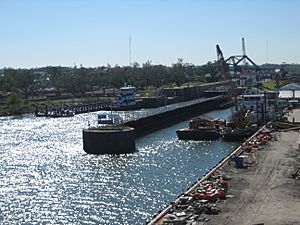
The Industrial Canal Lock connects the canal to the Mississippi River. This lock was built in the 1920s. It is shorter and narrower than most modern locks on the Mississippi River System. This makes it a busy bottleneck for ships. It connects two of the busiest waterways in the country.
The United States Army Corps of Engineers is working on a plan to replace this old lock. They want to build a new, larger lock north of Claiborne Avenue.
Some people who work in shipping say that a new lock is needed. They argue that without it, modern ocean ships cannot get into the Industrial Canal's inner harbor. This limits what the canal can be used for, like shipyards. They also say that less barge traffic shows the old lock is slowing down business.
However, others disagree. They use the same traffic numbers to say that a new lock is not needed. Local groups and environmental organizations have fought against the project. In 2006, a court ordered the Corps to follow environmental laws before continuing the project.
Bridges Over the Canal
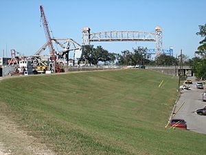
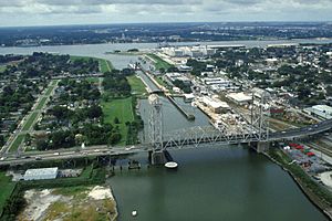
There are eight bridges that cross over the Industrial Canal. Each bridge is tall enough for ships to pass underneath. The bridges, starting from the north end of the canal, are:
- The first bridge is near Lake Pontchartrain.
- Then comes the next bridge.
- And so on, all the way to the Mississippi River.
 | Jackie Robinson |
 | Jack Johnson |
 | Althea Gibson |
 | Arthur Ashe |
 | Muhammad Ali |


