
Mississippi River System facts for kids
Quick facts for kids Mississippi River System |
|
|---|---|

Map of the course, watershed, and major tributaries of the Mississippi River
|
|

Mississippi River Tributaries
|
|
| Country | United States |
| Physical characteristics | |
| River mouth | LA |
The Mississippi River System is a huge network of rivers and waterways in the United States. It includes the famous Mississippi River and all the other rivers that flow into it. This amazing system is the largest drainage basin (an area where all water flows to a single river) in the U.S. In fact, it collects water from almost 60% of the country's rivers!
Naturally, the system is made up of the Mississippi River and its many tributaries (smaller rivers that flow into a larger one) and distributaries (channels that branch off a main river). Some of the biggest tributaries are the Arkansas, Illinois, Missouri, Ohio, and Red rivers. The Atchafalaya River is a major distributary that branches off before the Mississippi reaches the Gulf of Mexico.
For shipping and trade, the system also includes man-made waterways. These include the Illinois Waterway, the Tennessee-Tombigbee Waterway, and the Gulf Intracoastal Waterway. The U.S. Army Corps of Engineers keeps these waterways deep enough for barge transportation. Barges mostly carry large amounts of goods like grain, oil, gas, and coal. The Mississippi River alone carries 60% of U.S. grain shipments.
Contents
Major Rivers of the Mississippi System
The Mississippi River System is made up of many important rivers. Here are some of the longest and most significant ones:
| River | Length |
|---|---|
| 1. Upper Mississippi River | 1,250 miles |
| 2. Arkansas River | 1,469 miles |
| 3. Illinois River | 273 miles |
| 4. Missouri River | 2,522 miles |
| 5. Ohio River | 981 miles |
| 6. Red River | 1,290 miles |
The Upper Mississippi River

The Upper Mississippi River stretches about 1,250 miles. It starts at Lake Itasca and flows all the way to Cairo. Much of this part of the river flows through a special area called the Driftless Area. This area, about 15,000 square miles, avoided being covered by glaciers for the past two million years.
The river here is surrounded by tall limestone bluffs. These bluffs were shaped by melting water from glaciers after the last ice age. The riverbed itself has a thin layer of clay, silt, and sand. The Upper Mississippi River covers about half of the Mississippi River's total length. About 850 miles of it are deep enough for boats to travel. This part of the river is home to many different kinds of aquatic life. This includes 127 species of fish and 30 species of freshwater mussels.
The Arkansas River
The Arkansas River is a major tributary of the Mississippi River. It flows from west to east, starting in Colorado and emptying into the Mississippi River. It is 1,469 miles long and flows through Colorado, Kansas, Oklahoma, and Arkansas. This makes it the sixth longest river in the U.S. It is also the second longest tributary to the Mississippi River System.
The Illinois River

The Illinois River is another important tributary of the Mississippi River. It is about 273 miles long and flows through the state of Illinois. This river was very important to Native Americans and early French traders. It was a main water route connecting the Great Lakes with the Mississippi River. The Illinois River joins the Mississippi near Grafton, at Pere Marquette State Park. The view where the two rivers meet is truly amazing.
Like the Mississippi, the Illinois River is quite shallow. It is also a "managed" river, meaning humans control its flow. In 1848, the Illinois and Michigan Canal opened. This canal connected Lake Michigan to the Mississippi River through the Illinois River. This helped a lot with trade and business.
The Missouri River
The Missouri River is a very long river that starts in southwest Montana. It flows southeast for 2,522 miles, passing through six states. Finally, it joins the Mississippi River at St. Louis. The Missouri River is the longest river in North America. In the 1800s, it was a main route for people moving westward across the United States.
The Ohio River

The Ohio River is 981 miles long. It begins where the Allegheny River and the Monongahela River meet in Pittsburgh, Pennsylvania. It ends in Cairo, Illinois, where it flows into the Mississippi. The Ohio River collects water from parts of eight states. These states include Illinois, Indiana, New York, Ohio, Kentucky, Pennsylvania, Tennessee, and West Virginia.
This river can provide enough water for over five million people. At its widest point, near Smithland dam, it is one mile wide. The average depth is 24 feet. This depth allows many different kinds of fish to live there safely. There are about 150 species of fish in the Ohio River, from catfish to salmon and trout.
The river's depth also makes it useful for shipping goods on barges. On average, the Ohio River transports over 230 million tons of cargo each year. About 70% of this cargo is energy resources like coal. The Ohio River also helps create energy. There are 20 dams and 49 other power-generating facilities along the river.
The Red River
The Red River is the 10th longest river in the United States. It is 1,290 miles long. It starts near the Rocky Mountains and flows through several states. The main part of the river is in Texas. It also crosses through Oklahoma, Arkansas, and Louisiana, where it connects to the Mississippi River. The Red River mostly flows through rural farmland. The only major cities nearby are Shreveport, Louisiana and Alexandria, Louisiana. The Red River area has many oil fields, and oil and gas production is a big part of its economy.
Major Branches of the Mississippi River
The Mississippi River Delta

The Mississippi River Delta was formed over thousands of years. The Mississippi River deposited sand, clay, and other materials into the northern Gulf of Mexico. This delta is home to a huge amount of wildlife. It has also helped the U.S. become a powerful country because of the economic growth it has brought.
However, over the last 300 years, the delta has been shrinking. This is due to human changes to the river system. As the delta gets smaller, the natural protection it provides for the land also decreases. The delta is very important for the wildlife and people who live there, and for the U.S. economy. If the land loss continues, all these benefits could disappear.
The Atchafalaya River

The Atchafalaya River is one of the main distributaries (branches) of the Mississippi River System. It is about 170 miles long, making it one of the longest branches of the Mississippi. Its name comes from a Native American word meaning "long river." This river is important for trade because it makes the journey to the Gulf of Mexico shorter. This saves companies time and money.
The Old River Control Structure is a system that sends some of the Mississippi River's water into the Atchafalaya River. This control system makes sure that 30% of the combined flow of the Mississippi and Red Rivers goes down the Atchafalaya. The rest of the water continues down the main Mississippi River.
How People Have Used the River System
Historical Uses
The Mississippi River System has always been very important to the people living nearby. Many different Native American groups, like the Ojibwa, Winnebago, Fox, and Choctaw Indians, lived in the area. They were attracted by the many resources and the river's large size. They were the ones who named the Mississippi River. They used it for farming, fishing, and trading with other groups.
Most of the native people in the river area were hunters and gatherers. The Mound Builders were a civilization that made major farming settlements along the rivers. The rich soil left by the river's floods made these areas perfect for farming. We don't know exactly why they built earth mounds, but some think they were used for religious ceremonies.
During the U.S. Civil War, the river system, especially the Mississippi River, was used by Union armies to move troops and supplies. Many big battles were fought along its banks. The famous writer Mark Twain was greatly influenced by his experiences on the rivers. His stories helped shape American literature.
Modern Uses

Today, the Mississippi River System and its connecting rivers are mainly used for transporting goods. These goods include farm products and manufactured items like iron, steel, and mine products. The two largest rivers in the system, the Mississippi and Missouri, are used the most for shipping. Over 460 million tons of goods are shipped on the Mississippi each year. The most common way to transport cargo is by tugboats pushing large barges.
Commerce and Trade on the River
The Mississippi River System plays a huge role in the U.S. economy. It handles 92% of the nation's farm exports. This includes 78% of the world's feed grains and soybeans. It is also home to some of the biggest ports in the U.S., such as the Port of South Louisiana and The Port of New Orleans.
These two ports together handle over 500 million tons of shipped goods each year. This is much more than most other U.S. ports. Common items shipped include petroleum, iron, steel, grain, rubber, paper, wood, coffee, coal, chemicals, and edible oils.
Goods Moving Up and Down the River
Upbound Commodities (moving upstream)
| Commodity | Percentage |
|---|---|
| Sand and Gravel | 47% |
| Fertilizer | 24% |
| Salt | 9% |
| Cement | 10% |
| Misc. | 10% |
Downbound Commodities (moving downstream)
| Commodity | Percentage |
|---|---|
| Grain (soy, corn, wheat) | 87% |
| Asphalt | 4% |
| Potash | 3% |
| Misc. | 6% |

The River's Natural Environment
Natural History of the River System
About two billion years ago, forces in the environment shaped the land around the Mississippi River System. This created the mountain systems we see in North America. Over time, Erosion (the wearing away of land) carved out depressions in the ground. Many years later, the land continued to be shaped by oceans overflowing. This caused constant flooding, which helped form the Mississippi River System.
Around two million years ago, huge glaciers up to 6,500 feet thick changed the environment even more. When these glaciers melted about 15,000 years ago, at the end of the last ice age, they left vast amounts of water in North America. This water created the rivers we know today.
The Mississippi River started as a tiny stream from Lake Itasca in northern Minnesota. It then flowed 2,350 miles south to the Gulf of Mexico. Today, the Mississippi River is connected to hundreds of tributaries, forming the large Mississippi River System.
Wildlife in the Mississippi System
.jpg)
The Mississippi River and its surrounding floodplains are home to many different species. There are at least 260 different kinds of fish in the Mississippi. Forty percent of the United States' migratory waterfowl (birds that fly long distances) use the Mississippi River corridor. They use it during their Spring and Fall migrations. Sixty percent of all North American birds (326 species) use the river basin as their migratory flyway.
There are 38 known species of mussel found from Cairo, IL upstream to Lake Itasca. The lower part of the Mississippi may have as many as 60 different mussel species. More than 50 mammal species live in the Upper Mississippi area. Also, at least 145 species of amphibians and reptiles can be found there.
Human Impact on the River
The biggest impact humans have on the Mississippi River System is pollution. Even though the government tries to control it, pollution still gets into the water. Fertilizers and insecticides from farms often wash into the river. This harms the river's ecosystems.
Today, the Mississippi River has been greatly changed by human actions. Faster runoff and more sediment (dirt and particles) are affecting the system. This is because erosion is washing away topsoil from large farming areas.
Flooding and River Control

In 1993, the Mississippi River flood caused huge damage. It covered seventeen thousand square miles across nine states. It was the worst flood in U.S. history. It's called a hundred year flood because it has a 1 in 100 chance of happening in any given year. Over fifty people died, and homes were severely damaged. The economic losses were between $10 and $12 billion. About 20% of the people living near the flooded area moved away due to hardship.
Today, the Army Corps of Engineers is in charge of maintaining the rivers. Their goal is to "straighten, channelize, regularize and shackle the Mississippi." To help prevent more flooding, the Corps built levees (raised banks) about a mile apart. These levees help control the river and prevent it from eroding the shore. There are also several floodways throughout the system. These channels divert large amounts of water to prevent it from building up. While floodways help prevent floods, they can sometimes make it harder for farming to thrive in nearby areas.
Images for kids
-
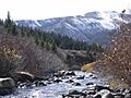
The headwaters of the Arkansas near Leadville, Colorado
-
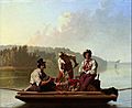
Boatmen on the Missouri c. 1846
-
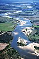
Red River near Bonham, Texas on the Texas-Oklahoma border


