
Old River Control Structure facts for kids


The Old River Control Structure is a huge system of floodgates in central Louisiana. It helps control how much water flows from the mighty Mississippi River into the Atchafalaya River. Its main job is to stop the Mississippi River from changing its path completely.
This important structure was finished in 1963. It was built by the U.S. Army Corps of Engineers. They built it in a special side channel of the Mississippi called "Old River." This complex includes the original structures, plus an extra one built after a big flood in 1973. It also has a lock for boats and a power station that makes electricity.
Contents
Why is the Old River Control Structure Important?

Long ago, before the 1400s, the Red River and the Mississippi River flowed separately. They ran mostly side-by-side. But then, the Mississippi River started to curve westward. This curve was called Turnbull's Bend.
Eventually, this bend met the Red River. This made the lower part of the Red River become a branch of the Mississippi. This new branch was named the Atchafalaya River.
How the Rivers Changed Over Time
During the time of steamboats on the Mississippi, Turnbull's Bend was a problem. It was about 20 kilometres (12 mi) long, but boats only moved about 1 kilometre (0.62 mi) forward after hours of travel. To save time, Captain Henry M. Shreve dug a shortcut in 1831. This shortcut was called Shreve's Cut.
When the water was high, the Mississippi rushed through this new channel. The upper part of Turnbull's Bend became "Upper Old River." The larger lower part became "Lower Old River."
At first, the Lower Old River flowed east to the Mississippi. But then, people cleared a huge log jam in the Atchafalaya River. After that, the Lower Old River sometimes flowed east and sometimes west. Over time, it flowed west more and more often. By 1880, it almost always flowed west. It was quickly taking more and more water from the Mississippi. This extra water made the Atchafalaya River wider and deeper over many years.
The Mississippi River's Changing Path
The U.S. Army Corps of Engineers watched how much water flowed through the Mississippi and into the Atchafalaya. They found that between 1850 and 1950, the amount of water going into the Atchafalaya River grew from less than 10% to about 30%.
By 1953, the Corps realized something big. The Mississippi River could change its main path to the Atchafalaya River by 1990 if nothing was done. This is because the Atchafalaya River offers a much shorter and steeper path to the Gulf of Mexico.
The Corps finished building the Old River Control Structure in 1963. This was to stop the Mississippi River from changing its main course. Rivers naturally change their paths over thousands of years, a process called avulsion. This change was expected to happen soon. Some experts believe it could still happen, even with the control structure.
If the Mississippi River changed its main path, it would create a new delta near Morgan City. This would greatly reduce water flow to cities like Baton Rouge and New Orleans. This would cause big economic problems for these important port cities.
The Mississippi Flood of 1973 almost caused the control structure to fail. Keeping the Old River Control Structure, the nearby Morganza Spillway, and other levees strong is very important. This prevents the Mississippi from changing its course. Experts say a failure here would be a serious blow to the U.S. economy.
What are the Parts of the Old River Control Structure?

The Old River Control Structure was completed in 1964 and made bigger in 1990. It has several key parts:
- Low Sill Control Structure: This part manages the normal, everyday flow of water.
- Overbank Control Structure: This part is only used when the Mississippi River overflows its banks during very high floods.
- Navigation Channel and Lock: These allow boats to travel through the complex.
- Auxiliary Structure: This was added in 1986. It helps reduce pressure on the original structures, especially after the damage from the 1973 flood.
- Sidney A. Murray Jr. Hydroelectric Station: Finished in 1990, this power station also helps control water flow and generates electricity.
How Does the Old River Control Structure Work?
Water from the Mississippi River is usually sent into the Atchafalaya Basin only at Old River. Here, the floodgates are used to send water into the Atchafalaya River. The goal is to split the water flow so that about 70% stays in the Mississippi River and 30% goes into the Atchafalaya River. This split was decided based on how the rivers flowed when the structure was built.
The water that goes into the Atchafalaya Basin first enters the Red River. Then it flows down the Atchafalaya River to the Gulf of Mexico. This path bypasses cities like Baton Rouge and New Orleans.
The Morganza Floodway is another important structure nearby. It is usually closed. But in an emergency, it can be opened to release extra water from the Mississippi into the Atchafalaya. This helps reduce pressure on the Old River Control Structure and other flood defenses. The Morganza Floodway has only been opened twice since the Old River Control Structure was built.
Images for kids
-
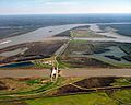
The Old River Control Structure complex. View is to the east-southeast, looking downriver on the Mississippi, with the three dams across channels leading to the Atchafalaya River to the right of the Mississippi. Concordia Parish, Louisiana is in the foreground, on the right, and Wilkinson County, Mississippi, is in the background, across the Mississippi on the left.
-
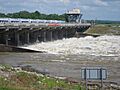
Old River Control Structure discharging water into the Atchafalaya, May 2011
-
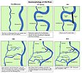
Formation of the Atchafalaya River and construction of the Old River Control Structure.
-
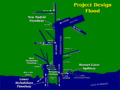
A diagram that depicts river flows associated with Project Design Flood.
