New Orleans East facts for kids
Eastern New Orleans is the eastern part of New Orleans, and it's the newest section of the city. It's surrounded by the Industrial Canal, the Intracoastal Waterway, and Lake Pontchartrain. This area started growing a lot in the 1950s. It has many neighborhoods and shopping centers that feel like a suburb, even though they are inside New Orleans.
Before Hurricane Katrina hit in 2005, Eastern New Orleans was starting to have some problems. The big floods after Katrina affected almost the entire area. Many stores and restaurants that were open before the hurricane decided not to reopen.
Around 85,000 people lived in Eastern New Orleans in 2017. This is a bit less than the 95,000 people who lived there in 2000. About ten percent of the city's property tax money comes from properties in Eastern New Orleans.
Contents
- A Look Back: History of Eastern New Orleans
- Growing Pains: Development and Changes
- After the Storm: Recovery and Rebuilding
- Exploring the Neighborhoods
- Important Places: Landmarks
- How Things Work: Infrastructure
- The Land Beneath Us: Geology
- Learning and Growing: Education
- Famous Faces: Notable People
A Look Back: History of Eastern New Orleans
Until the late 1800s, this area was outside the main city of New Orleans. However, it was still part of Orleans Parish.
The history of Eastern New Orleans goes back to the early 1800s. That's when Fort Pike and Fort Macomb were built. These forts were made to protect the waterways leading into New Orleans. The Rigolets Lighthouse was also built nearby.
Other important things happened in the 1800s. A road that became Chef Menteur Highway was built in Village de L’Est. Also, a sugar cane farm and factory were built in Venetian Isles. Once this road was finished, it was the only way to get to the eastern area from the rest of the city.
Much of this land was marsh, which is wet, swampy ground. Building the highway meant blocking, draining, and filling parts of a waterway called Bayou Metairie. Not many buildings were here except in two main spots. One was along a natural high ridge where Gentilly Road/Chef Menteur Highway now runs. Farms, plantations, and small towns like Michoud were built there. The other area had "camps," which were groups of houses built on tall wooden stilts near Lake Pontchartrain. The biggest of these was at Little Woods.
In the early 1900s, some homes started to be built, extending from the Gentilly area. The Industrial Canal was built between 1918 and 1923. This canal became a major barrier that separated Eastern New Orleans from the rest of the city. The southern border of Eastern New Orleans was set in 1944. This happened when the Gulf Intracoastal Waterway was rerouted. A new part of the waterway was dug from the Industrial Canal to the Rigolets, cutting through the swamp.
From the 1930s to the 1960s, Lincoln Beach was a popular amusement park for the African-American community. It was located on the shore of Lake Pontchartrain.
When Hurricane Betsy threatened New Orleans in 1965, Eastern New Orleans was the only part of the city told to evacuate. People worried it would be hit very hard. However, the damage from Betsy was not as bad as expected, except for some minor flooding.
Growing Pains: Development and Changes

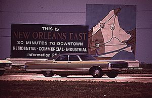
Eastern New Orleans grew very quickly in the 1960s. Many new neighborhoods were built in the 1960s and 1970s. These were for people who wanted a more suburban lifestyle but still wanted to live inside New Orleans. The area was planned well, with good zoning. Major roads were built with landscaped areas in the middle, called "neutral grounds." Many neighborhoods also had large lakes, which helped with drainage and made homes look nice.
From the late 1960s, power lines and other utilities were buried underground. This made the new parts of Eastern New Orleans look much neater. It was different from other suburban areas with lots of visible wires and poles. At first, Eastern New Orleans was mostly white. By 1980, it also had many offices and stores. The biggest shopping mall in the area, The Plaza at Lake Forest, opened in 1974.
However, in the 1980s, the population started to change. More African-American middle-class families moved into Eastern New Orleans. Also, after the Oil Bust in 1986, more poverty came to the area. Many apartment complexes that were built for young professionals started to house poorer families. With more poverty came more crime. This caused many white residents to move away. By 2005, Eastern New Orleans was mostly African-American.
There were big plans to develop even more land further east during the oil boom of the 1970s. This included a huge planned community called "New Orleans East." It was supposed to be like other well-planned cities. However, only small parts of it were ever built. Much of this land later became the Bayou Sauvage National Wildlife Refuge. This is the largest urban wildlife refuge in the United States.
There were also ideas to build a new international airport in the far eastern part of the area. Studies were done in the late 1960s to see if New Orleans International Airport could move there. They even picked a spot for runways on a man-made island. But in the early 1970s, they decided to just expand the current airport. Later, Mayor Sidney Barthelemy also suggested building a new airport. However, people worried about the environment and many residents were against it, so the idea was dropped.
After the Storm: Recovery and Rebuilding
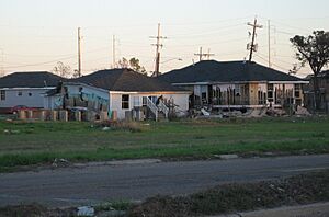
On August 29, 2005, most of Eastern New Orleans was severely flooded by Hurricane Katrina. This happened because the levees (protective walls) failed. Recovery was very slow at first. By early 2006, only a few businesses had reopened. Utility services were fully back by the end of 2006.
By January 2007, less than half of the people who lived there before Katrina had returned. Many were living in temporary homes while they fixed their damaged houses. By November 2006, only 40,000 residents had come back, compared to 95,000 before the floods. However, the population slowly started to grow again. By 2010, more than half of the pre-Katrina population had returned.
The people who returned were often wealthier. Homeowners wanted fewer apartment buildings. So, there are now fewer rental homes in Eastern New Orleans than before Katrina. Important services also became harder to find. Only one grocery store reopened, and many national stores were slow to come back. Also, the hospitals did not reopen for many years. New Orleans East Hospital (NOEH) opened in 2014. It was the first hospital in the area since Katrina.
In the years after Hurricane Katrina, recovery has sped up. Many new stores have opened, especially near I-10 and Bullard Avenue. Big stores like Wal-Mart have returned. There are also many black-owned businesses. A new CVS Pharmacy, Daughters of Charity Health Center, and New Orleans East Hospital have opened along Read Boulevard.
The city has also invested a lot of money in the area. This includes the new hospital, a new public library, and improvements to Joe Brown Memorial Park. Several new public schools have also been built. The city is also working to bring new businesses to the site of the old Plaza mall and the former Six Flags/Jazzland amusement park. The amusement park closed before Hurricane Katrina and never reopened.
On February 7, 2017, a strong tornado hit Eastern New Orleans. It damaged or destroyed several buildings. 33 people were hurt, and six were seriously injured.
Exploring the Neighborhoods
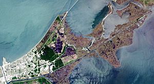
Eastern New Orleans covers a huge area. However, most of it is undeveloped wetlands. In the parts that are built up, you can find many different neighborhoods. These include Pines Village, Plum Orchard, West Lake Forest, Read Boulevard West, Little Woods, Read Boulevard East, Village de L’Est, Lake Catherine, and Venetian Isles.
Pines Village: An Early Community
Pines Village is one of the first neighborhoods built in Eastern New Orleans. It's close to Chef Menteur Highway and the Industrial Canal. Sigmund Pines bought and developed this area for homes in the 1950s. To build it, they had to create levees, lower the water level, fill the land, and build a drainage system with lakes and canals.
Smaller Communities
Today, Eastern New Orleans also has many smaller neighborhoods. They are often named after lakes, streets, or subdivisions. Some examples are Lake Willow, Spring Lake, Kenilworth, Seabrook, Melia, Edgelake, Bonita Park, Donna Villa, Willowbrook, Cerise-Evangeline Oaks, and Castle Manor.
Read Boulevard East: A Changing Area
The Read Boulevard East area started growing in the 1970s. It was originally called Lake Forest. By the late 1990s, the neighborhoods here were no longer mostly white. Instead, they became a popular place for African-American professionals and business owners to live.
Beyond I-510: The Easternmost Parts
Not much is built east of I-510. This large area is still part of New Orleans. It includes the Bayou Sauvage National Wildlife Refuge, Chef Menteur Pass, Fort Macomb, and historic Fort Pike. You can also find rural areas like Venetian Isles, Irish Bayou, and Lake Saint Catherine.
Village de L'Est: A Vibrant Vietnamese Community
Village de L'Est is one of the few busy neighborhoods east of I-510. It is well-known for its Vietnamese community. This community is also called Versailles. The first Vietnamese people came here after 1975 and settled in the Versailles Arms apartment complex. The main business area for this community is along Alcee Fortier Boulevard. Sometimes called "Little Vietnam," this area has many Vietnamese restaurants, including Dong Phuong Restaurant & Bakery.
Important Places: Landmarks
Eastern New Orleans has several important places and landmarks. These include the Lakefront Airport, Joe Brown Memorial Park, the Audubon Louisiana Nature Center, Lincoln Beach, and NASA's Michoud Assembly Facility.
The Lafon Nursing Facility is also here. It is one of the oldest nursing homes in the United States.
How Things Work: Infrastructure
The New Orleans Power Station and the former Michoud Power Station are located in Eastern New Orleans.
One special thing about Eastern New Orleans is that most of its power lines and other utilities have been buried underground since the late 1960s. This makes the area look very neat and tidy. You won't see many wooden utility poles or tangled wires like in other suburban areas. Having buried power lines also means the area is less likely to lose power during storms.
The Land Beneath Us: Geology
Eastern New Orleans, especially the Michoud area, sits on the edge of a fault line. This means the land and the levees (protective walls) are slowly sinking. Recent studies show the land is sinking about two inches each year.
Learning and Growing: Education
Schools for All Ages
Public Schools
The New Orleans Public Schools system oversees many public charter schools in Eastern New Orleans.
- Marion Abramson High School was in Eastern New Orleans but closed after Hurricane Katrina in 2005.
- The Abramson Science and Technology Charter School opened on the old Abramson High School site in 2007.
- In 2010, Sci Academy (New Orleans Charter Science and Math Academy) moved to the Abramson site. Most students came from Eastern New Orleans and Gentilly.
- Sarah T. Reed High School is also in Eastern New Orleans.
- Miller-McCoy Academy, an all-boys charter school, was in Eastern New Orleans from 2008 to 2015.
Private Schools
- St. Mary's Academy was founded in 1867 by Venerable Mother Henriette DeLille and the Sisters of the Holy Family.
Public Libraries
The New Orleans Public Library operates the Eastern New Orleans Branch. The current library building is a modern design that opened in 2012. It cost $7.6 million to build. The building is about 27,000 square feet.
Famous Faces: Notable People
- Shante Franklin, Curren$y, a rapper from Eastern New Orleans
- Ruby Bridges
- Poppy Z. Brite, grew up in Eastern New Orleans
- Will Clark, Professional Baseball Player
- Jacoby Jones, whose family house was destroyed by Hurricane Katrina
- Aaron Neville
- Irma Thomas, Grammy Award Winner and "Soul Queen of New Orleans"
 | Dorothy Vaughan |
 | Charles Henry Turner |
 | Hildrus Poindexter |
 | Henry Cecil McBay |


