
Bayou Metairie facts for kids
Bayou Metairie was an old waterway, like a small river, that used to flow through what is now New Orleans, Louisiana, USA, and Jefferson Parish, Louisiana, USA. It stretched from an area called River Ridge all the way to Bayou St. John. Most of Bayou Metairie was filled in during the late 1800s and early 1900s, but you can still find parts of it today.
Contents
How Bayou Metairie Formed
Long, long ago, about 2,600 years ago, the mighty Mississippi River flowed along the path that later became Bayou Metairie. As the river flowed, it dropped off mud and sand, which built up the land around its edges. This created natural banks, making the ground higher there.
Over many years, the Mississippi River slowly changed its path to where it flows today. This left behind the old river channel, which became Bayou Metairie. The higher ground along its old banks remained, forming a long, narrow strip of land called the Metairie - Gentilly Ridge.
The Metairie - Gentilly Ridge
This ridge was like a natural levee, following the path of Bayou Metairie. At its widest point, it was about a mile across. As it went eastward, it became much narrower. The ridge was about seven feet higher than the land around it.
Water from the Mississippi River would sometimes flow into Bayou Metairie. But around the year 1700, the river stopped flowing into it completely. This left Bayou Metairie as a separate, quiet waterway.
Where Bayou Metairie Flowed
Bayou Metairie wound its way for about 20 miles towards the east. It flowed through what are now Jefferson Parish and Orleans Parish, running roughly parallel to the current Mississippi River.
Eventually, Bayou Metairie connected northward to Lake Pontchartrain. This connection became known as Bayou St. John. The parts of Bayou Metairie that were east of Bayou St. John were later called Bayou Savage and Bayou Gentilly. You can see these old waterways and the Metairie - Gentilly Ridge on maps from the 1800s, like the 1849 Sauvé's Crevasse map.
Early Uses of the Bayou
For a very long time, indigenous people used Bayou Metairie and the high ground of the Metairie - Gentilly Ridge. This ridge was a good place to live and travel because it was higher and drier than the surrounding swampy land.
Later, early European settlers used the land on the ridge for small farms and gardens. The soil was fertile, and being on higher ground made it good for growing crops. Some small farms were set up as early as 1708, even before the city of New Orleans was officially founded.
Bayou Metairie itself was not always easy to travel on. Only small boats could use it, and only sometimes, depending on the wind and water levels. In the early days of New Orleans, people who were smuggling goods or people seeking freedom sometimes used Bayou Metairie and the ridge to move around secretly.
Bayou Metairie Today
As New Orleans and the surrounding areas grew in the late 1800s and early 1900s, much of Bayou Metairie was filled in to make way for buildings and roads. By the early 1900s, only small parts of the bayou remained.
You can still see remnants of Bayou Metairie today. For example, some of the lagoons in New Orleans City Park, like the area around the Dueling Oaks, are parts of the old bayou. Early land developers even promoted these areas because they were easy to reach from New Orleans.
The Metairie - Gentilly Ridge, which followed part of the bayou's path, is now where Metairie Road runs in Jefferson Parish, Louisiana.
Different Names for the Bayou
The indigenous people in the area called Bayou Metairie "Bayou Tchoupitoulas." Spanish settlers knew it as "Arroyo de la Alqueria." French settlers referred to the Metairie - Gentilly Ridge as "Chemin de la Métairie," which means "Farm Road."
Images for kids
-
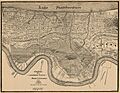
This 1849 map shows how Bayou Metairie flowed from east to west.
-
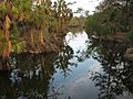
A small part of Bayou Metairie that still exists in New Orleans City Park.
-
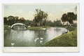
This area, known as "The Lake" at Metairie Cemetery, is another remnant of Bayou Metairie.
-
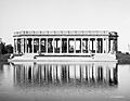
The Peristyle at New Orleans City Park stands next to a lagoon, which is a remaining part of Bayou Metairie.


