Bayou St. John facts for kids
Quick facts for kids Bayou Saint John |
|
|---|---|

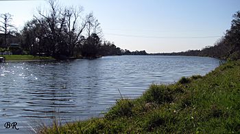
Bayou St. John by the Spanish fort
|
|
| Native name | Bayouk Choupic |
| Country | United States |
| Location | Louisiana |
| Physical characteristics | |
| Main source | New Orleans 0 ft (0 m) 29°58′24″N 90°05′29″W / 29.9733°N 90.0913°W |
| River mouth | Lake Pontchartrain 30°01′38″N 90°04′58″W / 30.0272°N 90.0827°W |
Bayou St. John (which means "Bayou Saint-Jean" in French) is a natural waterway in the city of New Orleans, Louisiana. It's a really important part of the city's history and natural landscape.
Contents
The Bayou's Natural Role
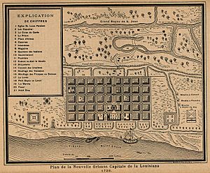
Bayou St. John was originally a natural stream that helped drain the swampy land where New Orleans now stands. It carried water from these areas into Lake Pontchartrain. In the past, the bayou was much longer than it is today. Old maps from the 1700s and early 1800s show that it had smaller branches. These branches reached into areas that are now neighborhoods like Broadmoor and Carrollton.

Early Uses of the Bayou
The part of the bayou we see today was easy to travel on with small boats like canoes. Native American tribes used this waterway for thousands of years, even before Europeans arrived. They called it Bayouk Choupic.
There was a special path called a "portage" that connected the bayou to the Mississippi River. A portage is a place where people carry their boats over land from one body of water to another. This was needed because the bayou's water level was different from the river's. This important route attracted early French explorers and traders. Some of them even started a small community here in the late 1600s.
Fort St. Jean and New Orleans' Founding
In 1701, the French built a small fort called Fort St. Jean near where the bayou meets Lake Pontchartrain. This fort protected the important travel route. Later, people in New Orleans would call it "Old Spanish Fort". The bayou and its portage were key reasons why New Orleans was founded in 1718. The city was built at the end of this portage route, right by the Mississippi River.
Changes and Development
The portage trail along the bayou eventually became a wide road called "Grand Route St. John." This road was later replaced by the famous Esplanade Avenue.
Connecting to the City
After the Louisiana Purchase in 1803, a new waterway was dug. This was the Carondelet Canal. It connected the back of the city (which was then just a strip of land along the Mississippi River) to the bayou. The bayou itself was also deepened so that larger boats could use it. This made it easier to transport goods and people.
Cultural Traditions and Modern Use
In the 1800s, some people believed that areas along Bayou St. John were used for local cultural practices, especially by a famous figure named Marie Laveau. Today, the Magnolia Bridge over the bayou is still a special place for local traditions, especially on Saint John's Eve.
During the early 1900s, fewer commercial boats used the bayou, and the Carondelet Canal was filled in. For a while, some people lived in houseboats on the bayou. However, this was stopped in the 1930s due to concerns from nearby residents. A government project, the Works Progress Administration, then helped clean up and improve the area, making it more beautiful. A lock was also put in near Lake Pontchartrain. In 1955, the bayou was even temporarily drained to remove debris and bad smells.
Bayou St. John Today
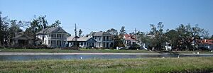
Today, Bayou St. John is a beautiful waterway in New Orleans. It has small earthen levees (raised banks) on both sides, creating a narrow park space. This area is a popular spot for people to relax and enjoy nature. The banks of Bayou St. John are also a very important meeting place for the Mardi Gras Indian tribes from downtown New Orleans. They gather there for their "Super Sunday" parade after Carnival.
In 2015, the Lafitte Greenway officially opened. This greenway runs along the path where the Carondelet Canal used to be, and it connects directly to the bayou. Because of this, Bayou St. John is now recognized as part of the EPA's Urban Waters Partnership, which helps protect and restore important urban waterways.
 | William Lucy |
 | Charles Hayes |
 | Cleveland Robinson |


