Inland waterways of the United States facts for kids
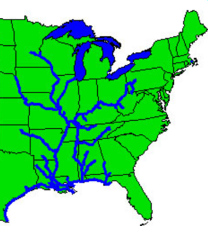
The inland waterways of the United States are like a huge network of water roads. They include over 25,000 miles (40,000 km) of rivers and canals that boats can travel on. A big part of these important waterways is the Mississippi River System, which includes the Mississippi River and all the waterways connected to it. These water routes are super important for moving goods across the country.
Contents
Where Are the Waterways?
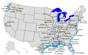
The Columbia River is the only major river on the West Coast that big boats can travel on for a long distance. This river is regularly dug deeper (dredged) so that freight barges can go as far inland as Lewiston, Idaho. They use a system of locks to help boats move up and down the river. However, there are rules about how deep boats can be past a certain point. Other rivers on the West Coast, like the Sacramento River, San Joaquin River, Snake River, and Umpqua River, are also dredged for boats. Most other West Coast rivers are too steep or have water levels that change too much for large boats. Many are also dammed for hydroelectricity and other uses.
Most of the navigable rivers and canals in the United States are in the eastern part of the country. This area has flatter land and more rain. The Mississippi River System, along with the Gulf Intracoastal Waterway (GIWW), connects ports on the Gulf Coast like Mobile, New Orleans, and Houston. It also links them to major inland cities such as Memphis, St. Louis, Chicago, and Pittsburgh.
The Lower Mississippi River, from Baton Rouge to the Gulf of Mexico, lets ocean ships connect with barges. This part of the river is very important for both trade within the U.S. and trade with other countries. The Mississippi River System is also connected to the Illinois Waterway, which then leads to the Great Lakes Waterway and the Saint Lawrence Seaway. Many other eastern rivers, like the Potomac River, Hudson River, and Atchafalaya River, are also kept clear for boats by the Army Corps of Engineers.
The U.S. government has laws that decide which waterways are considered "navigable." This means they are important for trade and travel, and certain rules apply to them. The Army Corps of Engineers helps figure this out. They look at whether a waterway has been used by boats in the past. Any waterway where the tide goes in and out is always considered navigable.
Why Are Waterways Efficient?
One of the best things about inland waterways is how well they can move huge amounts of goods over long distances. Special boats called towboats push many barges linked together, forming a "tow." A tow can have four to six barges on smaller waterways, and over 40 barges on the Mississippi River!
On larger rivers with locks, like the Ohio River, a 15-barge tow is common. These tows are super efficient. They can move about 22,500 tons of cargo at once. Imagine this: a single 15-barge tow carries as much as about 225 railroad cars or 870 large trucks! If all the cargo moved by waterways each year had to go by other methods, it would need 6.3 million more rail cars or 25.2 million more trucks.
Moving cargo by barge also saves a lot of fuel and is better for the environment. On average, one gallon of fuel can move one ton of cargo:
This means barges cause less Carbon dioxide pollution. Using waterways helps save fuel, reduces greenhouse gases and air pollution, lessens traffic jams, and leads to fewer accidents on roads and railways.
What Goods Travel on Waterways?
Barges are perfect for moving large amounts of raw materials and bulk goods at a low cost. The inland and intracoastal waterway system moves about 630 million tons of cargo every year. This is about 17 percent of all goods moved between cities by volume. These are usually raw materials or basic products that will be processed further or sent to other countries.
- Coal is the biggest type of cargo moved on inland waterways. Power plants that make electricity depend on these waterways for over 20 percent of the coal they use.
- Petroleum products come next. This includes crude oil, gasoline, diesel fuel, jet fuel, and asphalt.
- Grain and other farm products are another large group. Most of these go by waterway to ports on the Lower Mississippi River or Columbia River to be shipped overseas. Sixty percent of the country's farm exports travel through inland waterways.
- Other important goods include aggregates (like stone, sand, and gravel used in building), chemicals (including fertilizers), metal ores, and steel.
How Waterways Help the Economy
Inland and intracoastal waterways serve 38 states across the heartland of the U.S., as well as states on the Atlantic seaboard, the Gulf Coast, and the Pacific Northwest. Businesses and people in these states rely on inland waterways to move about 630 million tons of cargo each year, worth over $73 billion.
States on the Gulf Coast and throughout the Midwest and Ohio Valley especially depend on these waterways. Texas and Louisiana each ship more than $10 billion worth of cargo annually. States like Illinois, Pennsylvania, West Virginia, Kentucky, Mississippi, Alabama, and Washington state each ship between $2 billion and $10 billion every year. Another eight states ship at least $1 billion annually.
Research shows that moving cargo by waterway saves about $10.67 per ton compared to other ways of shipping. This adds up to over $7 billion in transportation savings for the U.S. economy each year!
Keeping Waterways Modern and Maintained
The U.S. Army Corps of Engineers (USACE) is in charge of maintaining 12,000 miles (19,000 km) of waterways, including the Intracoastal Waterway. Most of the important inland waterways are kept up by the USACE. Commercial boats that use these waterways pay a special fuel tax. This tax goes into the Inland Waterways Trust Fund, which pays for half the cost of building new parts of the waterway system and fixing old ones.
The nearly 12,000 miles (19,000 km) of U.S. inland and intracoastal waterways maintained by the Army Corps of Engineers include 191 active lock sites with 237 lock chambers. Locks are like water elevators that help boats move up or down between different water levels. They are key to letting tows travel to distant inland ports like Minneapolis, Chicago, and Pittsburgh.
Most locks are either 1,000 to 1,200 feet (300 to 370 m) long, or 600 to 999 feet (183 to 304 m) long. About 25 percent are less than 600 feet (180 m) long. Most locks are 110 feet (34 m) wide. The 1,200-foot (370 m) locks can fit a tow of 17 barges plus the towboat. But the 600-foot (180 m) locks can only fit about eight barges plus the towboat. The size of the lock and the tow are very important for how much cargo can pass through at one time.
More than half of the locks and dams run by the Army Corps of Engineers are over 50 years old. Many of the 600-foot (180 m) locks were built in the 1930s or even earlier. These older structures are reaching the end of their useful life and need to be updated or fixed. Since many tows today have 12 or more barges, they have to be "cut" into two sections to pass through a 600-foot (180 m) lock. This takes a lot of time and can cause long lines of tows waiting.
Since the 1960s, the U.S. Army Corps of Engineers has been working to modernize the locks on the Ohio River. They added 1,200-foot (370 m) chambers that let a typical tow pass through in one go. This modernization is still happening today. For example, a new dam with two 1,200-foot (370 m) locks is being built at Olmsted, Illinois, where the Ohio and Mississippi rivers meet. Another 1,200-foot (370 m) chamber is being built at McAlpine Locks and Dam near Louisville.
Modern 1,200-foot (370 m) chambers are also being built at Kentucky Lock on the Tennessee River and at the Inner Harbor Lock on the Gulf Intracoastal Waterway at New Orleans. Other projects are happening in Pennsylvania, West Virginia, and Arkansas. Many major repairs are also underway. All this work is an investment of over $3.5 billion to modernize inland waterways, and it will be finished over the next ten years. Half of this money comes from the fuel taxes paid by the inland towing industry. These projects not only improve navigation but also help protect and restore the natural environment.
The Army Corps of Engineers is also studying ways to improve other parts of the inland waterway system. These studies will help figure out what navigation and environmental actions are needed to support the system in the future.
 | Janet Taylor Pickett |
 | Synthia Saint James |
 | Howardena Pindell |
 | Faith Ringgold |


