
Patapsco River facts for kids
Quick facts for kids Patapsco River |
|
 Patapsco Valley State Park at Catonsville.
|
|
| Country | United States |
|---|---|
| State | Maryland |
| Tributaries | |
| - left | North Branch |
| - right | South Branch |
| Cities | Baltimore, Elkridge, Ellicott City |
| Source | |
| - location | Marriottsville |
| - elevation | 260 ft (79 m) |
| - coordinates | 39°20′59″N 76°52′56″W / 39.3498272°N 76.8821987°W |
| Mouth | Chesapeake Bay |
| - location | Baltimore |
| - elevation | 0 ft (0 m) |
| - coordinates | 39°10′25″N 76°26′36″W / 39.1737202°N 76.4432935°W |
| Basin | 632 sq mi (1,637 km²) |
The Patapsco River is a river in the state of Maryland in the United States. It is about 39 miles (63 km) long. The name "Patapsco" comes from the language of the Algonquian tribe of Native Americans. The Algonquian word pota-psk-ut means "backwater" or "tide covered with froth." This name describes how the river looks where it meets the ocean.
The Patapsco River flows through central Maryland. It eventually empties into the Chesapeake Bay. The place where the river meets the bay is very important. It forms the Inner Harbor of the city of Baltimore.
River Branches
The Patapsco River has two main parts, called tributaries or branches. These branches flow into the main river.
North Branch
The North Branch of the Patapsco River flows towards the north. It is one of the two main sources of the river.
South Branch
The South Branch of the Patapsco River flows towards the east. This branch forms the northern border of Howard County, Maryland.
Related Places
Images for kids
-
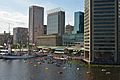
The Inner Harbor viewed from the Baltimore Aquarium
-

Liberty Reservoir
-

Volunteers at a community cleanup of Herbert Run, a tributary of the Patapsco River running through Arbutus, Maryland


See also
 In Spanish: Río Patapsco para niños
