Catonsville, Maryland facts for kids
Quick facts for kids
Catonsville, Maryland
|
|
|---|---|

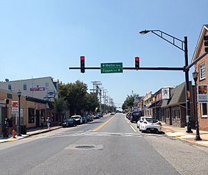
Frederick Road in Downtown Catonsville.
|
|
| Nicknames:
"Music City, Maryland", "Cville", "The Ville"
|
|
| Motto(s):
"Life is great in 21228"
|
|

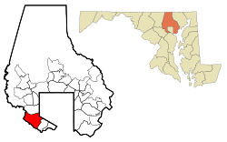
Location of Catonsville, Maryland
|
|
| Country | |
| State | |
| County | |
| Established | January 20, 1831 |
| Area | |
| • Total | 14.04 sq mi (36.37 km2) |
| • Land | 13.96 sq mi (36.16 km2) |
| • Water | 0.08 sq mi (0.21 km2) |
| Elevation | 479 ft (146 m) |
| Population
(2020)
|
|
| • Total | 44,701 |
| • Density | 3,201.85/sq mi (1,236.22/km2) |
| Time zone | UTC−5 (Eastern (EST)) |
| • Summer (DST) | UTC−4 (EDT) |
| ZIP codes |
21228, 21229, 21250
|
| Area code(s) | 410, 443, and 667 |
| FIPS code | 24-14125 |
| GNIS feature ID | 0583624 |
Catonsville (pronounced KAY-tunz-vil) is a community in Baltimore County, Maryland. In 2020, about 44,701 people lived there. It's like a neighborhood connected to the city of Baltimore, located right on its western edge.
Catonsville is known for being close to the Patapsco River and Patapsco Valley State Park. This makes it a great spot for outdoor activities like mountain biking. It's also famous for its lively music scene, which is why it's called "Music City, Maryland." A big part of the University of Maryland, Baltimore County (UMBC), a large public university with nearly 14,000 students, is located in Catonsville.
Contents
History
Before European settlers arrived, the land where Catonsville now stands was home to Native American tribes like the Piscataway or Susquehannocks.
Long ago, a road called Rolling Road was used to move tobacco from farms to the Patapsco River.
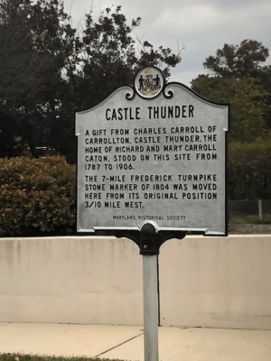
In 1787, the Ellicott family built the Frederick Turnpike. This road helped them transport goods from their flour mill to the Baltimore harbor. Charles Carroll, who signed the Declaration of Independence, owned the land nearby. He asked his son-in-law, Richard Caton, to develop the area. Richard Caton and his wife, Mary Carroll Caton, lived in a house called Castle Thunder, built in 1787.
Richard Caton gave his name to the community, calling it "Catonville." Later, in the 1830s, the name changed to "Catonsville." Businesses grew along the Frederick Turnpike to serve travelers going between Ellicott City and Baltimore. Catonsville became a popular stop, and the town grew quickly. Wealthy people from Baltimore built large summer homes here to escape the city heat. Many of these homes were built in the Victorian and colonial styles.
In 1862, horse-drawn streetcars connected Catonsville to Baltimore. Then, in 1884, the Catonsville Short Line railroad was built. This allowed people to travel to Baltimore for work easily. By the 1890s, with new electric streetcar lines and fancy housing, Catonsville became one of the first "commuter suburbs" in the United States. This means people lived in Catonsville and traveled to Baltimore for their jobs. Baltimore has tried to make Catonsville part of the city several times, but it hasn't happened. The last attempt was in 1918.
New homes were built quickly until the 1970s. A modern business area also opened along the Baltimore National Pike.
In 1968, a group called the "Catonsville Nine" became famous for a protest. These Catholic anti-war activists burned draft records to protest the Vietnam War.
In 2002, the state of Maryland officially named Catonsville "Music City, Maryland." This was because of all the music stores, performance places, and music schools in the area. There's even a music series called Life Sounds Great that features local musicians.
In 2007, Money magazine said Catonsville was the 49th best place to live in the United States. It was also ranked the third best in Maryland and Virginia.
Geography
Catonsville is located at 39°16′26″N 76°44′17″W / 39.27389°N 76.73806°W. It covers about 14 square miles (36 square kilometers) of land.
Catonsville is in the Piedmont Region of Maryland. This area has rolling hills, streams, and rivers. To the east, Catonsville looks out over the Chesapeake Bay. The Appalachian Mountains are about 40 miles (64 km) to the west.
The main road in Catonsville is Frederick Road (Maryland Route 144). Other important roads include Johnnycake Road and Academy Road to the north. The Patapsco River forms the western and southern borders. Catonsville is next to Woodlawn to the north, Baltimore to the east, and Ellicott City to the west.
Major highways like Interstate 695 (the Baltimore Beltway) and U.S. Route 40 (Baltimore National Pike) pass through or near Catonsville. The town is also the starting point for the Trolley Line Number 9 Trail and the Short Line Railroad Trail, which are great for walking or biking.
Transportation
Public Transit
The Maryland Transit Administration offers bus services in Catonsville. These buses can take you to Downtown Baltimore and other nearby areas. The MARC Train also has a commuter train station nearby in Arbutus.
Roads
Here are some of the main roads in Catonsville:
 Interstate 695 (Baltimore Beltway): This highway goes around Baltimore, connecting Catonsville to places like Glen Burnie and Towson.
 Interstate 195 (Metropolitan Boulevard): This road goes from southern Catonsville to BWI Airport.
 Maryland Route 166 (S. Rolling Road): This road goes north and south through the area.
 Interstate 70: This highway goes east and west from Catonsville towards Frederick.
 U.S. Route 40 (Baltimore National Pike): This road connects Catonsville to Baltimore and Ellicott City.
 Maryland Route 144 (Frederick Road): This is a main east-west road that runs through Catonsville.
 Maryland Route 372 (Wilkens Avenue): This road also travels east and west in the area.
Neighborhoods
Catonsville has many different neighborhoods, including:
- Academy Heights: A community near Mount de Sales Academy.
- College Hills: A newer area close to the Community College of Baltimore County and University of Maryland, Baltimore County.
- Colonial Gardens: A neighborhood along Edmondson Avenue.
- Ingleside: Home to the Ingleside Shopping Center.
- Paradise: Located east of Downtown Catonsville.
- Summit Park: Found near the Baltimore County Public Library.
- Westchester: At the crossing of Westchester and Rockwell Avenues.
- Western Hills: North of Downtown Catonsville.
- Westview Park: Also north of Downtown Catonsville.
- Winters Lane: An older African-American neighborhood.
- Woodbridge Valley: North of Downtown Catonsville.
- Oak Forest Park: West of Downtown Catonsville.
- Arden Parke: A small residential area.
- Windwood: A neighborhood south of Frederick Road.
Population Facts
| Historical population | |||
|---|---|---|---|
| Census | Pop. | %± | |
| 1960 | 37,872 | — | |
| 1970 | 54,812 | 44.7% | |
| 1980 | 33,208 | −39.4% | |
| 1990 | 35,233 | 6.1% | |
| 2000 | 39,820 | 13.0% | |
| 2010 | 41,567 | 4.4% | |
| 2020 | 44,701 | 7.5% | |
| source: | |||
In 2010, Catonsville had a population of 41,567 people. Most residents were non-Hispanic white (73.4%), with 14.3% non-Hispanic black, 6.3% Asian, and 3.4% Hispanic or Latino.
Education
Public Schools

Students in Catonsville attend schools in the Baltimore County Public Schools system. The main high schools for the area are Catonsville High School, Woodlawn Senior High School, and Western School of Technology and Environmental Science.
Private Schools
- Mount de Sales Academy is a Catholic high school for girls.
- Saint Mark School and Parish is also in Catonsville.
- Al-Rahmah School is an Islamic school located in northern Catonsville.
Colleges and Universities
- The University of Maryland, Baltimore County (UMBC) is a major university located in Catonsville.
- The Community College of Baltimore County has a campus in Catonsville, right across from Catonsville High School.
Fun Places to Visit
Arts and Entertainment
- Earl and Darielle Linehan Concert Hall
- Lurman Woodland Theatre
- Retriever Activities Center
Museums
Parks and Recreation
- Catonsville Community Park
- Conservation and Environmental Research Areas of UMBC
- George F.Bragg Nature Study Center and Horticulture Center
- Gliston Park
- Joseph Beuys Sculpture Park
- Benjamin Banneker Historical Park
- Patapsco Valley State Park
- Short Line Railroad Trail
- Trolley Line Number 9 Trail
- Western Hills Community Park (Crosby Park)
- Westview Recreation Area
Historic Places
These places in Catonsville are listed on the U.S. National Register of Historic Places:
Famous People From Catonsville
Many interesting people have lived in or are from Catonsville:
- Benjamin Banneker: An amazing African-American inventor, scientist, and mathematician.
- John Wilkes Booth: A famous actor who attended a military academy in Catonsville when he was young.
- Charles S. Roberts: Known as "The Father of Wargaming" for creating popular board games.
- James Cardinal Stafford: An important leader in the Catholic Church.
Arts and Media
- Nan Agle: A children's book author.
- Duff Goldman: The star of the Food Network show Ace of Cakes.
- David Hasselhoff: A well-known actor.
- Kathleen Turner: A famous actor.
Music
- John Christ: Guitarist for the band Danzig.
- Greg Kihn: A rock musician.
- Bill Frisell: A talented jazz guitarist.
- Ric Ocasek: The lead singer of the 1980s band The Cars.
Sports
- Ken Dixon: A former pitcher for the Baltimore Orioles baseball team.
- Adam Kolarek: A professional baseball pitcher who won the World Series in 2020.
- Fritz Maisel: Known as the "Catonsville Flash," a former Major League Baseball player for the New York Yankees.
- Jeff Nelson: A former Major League Baseball pitcher.
- Wes Unseld: A Hall of Fame NBA basketball player and coach.
- Wes Unseld Jr: A professional NBA basketball coach.
Sports Teams
Catonsville has been home to several sports teams, including:
- Chesapeake Bayhawks: A former professional men's lacrosse team.
- Baltimore Tribe: A former professional lacrosse team.
- Maryland Bays: A former professional soccer team.
- UMBC Retrievers: The college sports teams for the University of Maryland, Baltimore County.
- Spring Grove Baseball Club: A semi-professional baseball team.
See also
 In Spanish: Catonsville (Maryland) para niños
 | Isaac Myers |
 | D. Hamilton Jackson |
 | A. Philip Randolph |


