
Patapsco Valley State Park facts for kids
Quick facts for kids Patapsco Valley State Park |
|
|---|---|
|
IUCN Category V (Protected Landscape/Seascape)
|
|

The Thomas Viaduct, a signature monument of Patapsco Valley State Park
|
|

Patapsco Valley State Park
Location in Maryland
|
|
| Location | Anne Arundel County, Baltimore County, Carroll County and Howard County, Maryland, United States |
| Nearest city | Baltimore, Maryland |
| Area | 14,270 acres (57.7 km2) |
| Elevation | 374 ft (114 m) |
| Designation | Maryland state park |
| Established | October 6, 1907 |
| Administrator | Maryland Department of Natural Resources |
| Website | Patapsco Valley State Park |
Patapsco Valley State Park is a super cool place to explore! It's a big park that stretches for about 32 miles (51 km) along the Patapsco River, just south and west of Baltimore, Maryland. This park covers more than 14,000 acres of land, which is like having over 10,000 football fields! In 2006, it was celebrated as Maryland's very first state park. The Maryland Department of Natural Resources takes care of it, making sure everyone can enjoy its beauty and fun activities.
Contents
Park History
How the Park Started
The idea for Patapsco Valley State Park began way back in 1906. A dam called Bloede's Dam was being built, and people realized they needed to protect the river from dirt and mud washing in from nearby farms. So, in 1907, the Patapsco State Forest Reserve was created. It started with 43 acres of land, donated by John Mark Glenn. Over time, more sections along the river were added, and it grew into one of the largest parks in Maryland!
The Civilian Conservation Corps
In 1933, a group called the Civilian Conservation Corps (CCC) came to the park. The CCC was a program during the Great Depression that gave jobs to young men. These workers helped build many of the park's facilities, like trails and shelters. They also planted lots of trees to help stop soil from washing into the river. This was important because too much dirt could clog the turbines of Bloede's Dam, which made electricity for nearby towns.
A Special Camp During World War II
During World War II, one of the CCC camps in the park became a special place. It was the first camp in the country for people who chose not to fight in the war because of their beliefs. These people, called conscientious objectors, served their country in other ways, like helping out at the park.
Modern Day Patapsco Valley
Today, parts of the park are included in the Patapsco Heritage Area. This means that the area is recognized for its important history and natural beauty. It helps make sure the park is protected and enjoyed by future generations.
Fun Activities and Park Areas
Patapsco Valley State Park offers tons of fun things to do! You can go hiking, fishing, camping, canoeing, horseback riding, or even mountain biking. It's also a great spot for a picnic with friends and family. The Baltimore City Paper even called it the "Best Place to Hike" in 2007!
Explore Different Park Areas
The park is divided into several areas, each with its own unique features:
- McKeldin Area: This is the westernmost part of the park. It has trails for horseback riding, mountain biking, and hiking. You can also play disc golf here or go fishing where the North and South branches of the Patapsco River meet.
- Daniels Area: This area used to be a mill town called Daniels. Now, the Daniels Dam creates calm water perfect for canoeing, kayaking, fishing, and swimming.
- Hollofield Area: Located in the middle of the park, this area has a campground with 73 sites. You'll find hiking trails and shelters built by the CCC in the 1930s. There's also a scenic overlook where you can see the whole river valley!
- Pickall Area: This spot is great for families, with picnic shelters and playgrounds.
- Hilton Area: Near Catonsville, the Hilton Area has a small campground with mini-cabins. There's also a nature center for kids and a fun tire playground. You can access the Saw Mill Branch Trail from here.
- Avalon/Glen Artney/Orange Grove Flour Mill Area: This area is full of history! You can see the famous Thomas Viaduct, the old Bloede's Dam (which is no longer there), and the Old Gun Road Stone Arch Bridge. The Avalon Visitor Center, though closed, is in a building that was once part of a mill town.
Swinging Bridges of Patapsco
The park is famous for its two awesome swinging bridges that cross the Patapsco River!
- The first bridge is at Orange Grove. It's about 1.6 miles (2.6 km) northwest of Avalon. Long ago, people from the Orange Grove mill community used bridges here to cross the river to work at the big Orange Grove Flour Mill. That mill burned down in 1905, but you can still cross the bridge today and explore its ruins.
- A second swinging bridge opened on November 4, 2006. It's at the end of the Grist Mill Trail and connects to Ilchester Road. This bridge makes it easy for people from Ellicott City and Catonsville to get into the park, which they couldn't do easily since Hurricane Agnes in 1972!

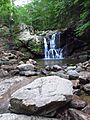
Cascade Falls
Don't miss Cascade Falls in the Orange Grove area! It's a beautiful waterfall that gently flows down a 10 to 15-foot (3 to 4.5 m) rock face. You can easily reach it by following a marked trail from the last parking lot in the Orange Grove area.
Images for kids
-
View of the waterfall.

