
Carroll County, Maryland facts for kids
Quick facts for kids
Carroll County
|
|||
|---|---|---|---|

Carroll County Courthouse in Westminster
|
|||
|
|||

Location within the U.S. state of Maryland
|
|||
 Maryland's location within the U.S. |
|||
| Country | |||
| State | |||
| Founded | January 19, 1837 | ||
| Named for | Charles Carroll of Carrollton | ||
| Seat | Westminster | ||
| Largest community | Eldersburg | ||
| Area | |||
| • Total | 453 sq mi (1,170 km2) | ||
| • Land | 448 sq mi (1,160 km2) | ||
| • Water | 5.1 sq mi (13 km2) 1.1% | ||
| Population
(2020)
|
|||
| • Total | 172,891 | ||
| • Estimate
(2023)
|
176,639 |
||
| • Density | 381.7/sq mi (147.36/km2) | ||
| Time zone | UTC−5 (Eastern) | ||
| • Summer (DST) | UTC−4 (EDT) | ||
| Congressional districts | 2nd, 3rd | ||


Carroll County is a county found in the state of Maryland. In 2020, about 172,891 people lived here. Its main town, or county seat, is Westminster. Carroll County is part of the larger Central Maryland region. It is also included in the Washington-Baltimore-Arlington, DC-MD-VA-WV-PA Combined Statistical Area. While it used to be mostly rural (farmland and countryside), it has become more suburban (areas near cities) in recent years.
Contents
Exploring Carroll County's Past
Early Inhabitants: Native American History
Before Europeans arrived, Native Americans lived on the land that is now Carroll County for thousands of years. Many old sites and tools from these groups have been found. They used the land for homes, seasonal visits, and hunting.
When Europeans first came, the Susquehannock and Lenape were the main Native American groups here. The area where Manchester is now was a Susquehannock settlement until about 1750. It was also where two important Native American trails crossed. One old trail, used by Algonquian and Iroquois groups, went from the Susquehanna River to the Potomac River. Main Street in Westminster was built over part of this trail. By the late 1700s, most roads in Carroll County followed old Native American paths.
Maryland Route 26 (Liberty Road) was built over another Native American trail. This trail went through the Freedom area in southern Carroll County. Native Americans used it to travel from the Blue Ridge Mountains to the Chesapeake Bay. This trail became a road and was named "Liberty" in the early 1800s. The land around Sykesville was used by the Susquehannock and Lenape for hunting. Taneytown was home to the Tuscarora people in the early to mid-1700s. They hunted deer, wolves, and other animals in the local forests. Later, the Tuscarora moved west due to land agreements.
How Carroll County Was Formed
Carroll County was created in 1837. It was made from parts of Baltimore and Frederick Counties. The county was named after Charles Carroll of Carrollton (1737–1832). He was an important person who signed the American Declaration of Independence.
Early European Settlers
The first European settlers in Carroll County were mostly Pennsylvania Dutch from southeast Pennsylvania. There were also English people from the Tidewater region of Maryland. The German language was commonly spoken in Carroll County until the Civil War. It was especially popular in the northern and western parts of the county. Towns like Hampstead, Manchester, and Taneytown had mostly German speakers. English speakers were a smaller group, living mainly in southern Carroll.
Carroll County During the Civil War
During the American Civil War, people in Carroll County had strong feelings. They were divided between supporting the Union (the North) and the Confederacy (the South). In 1863, many soldiers moved through the county as part of the Gettysburg campaign. On June 29, 1863, a small battle called Corbit's Charge happened in Westminster. Two companies of Delaware cavalry fought a much larger Confederate group.
Recent History and Community Values
In 2013, the Carroll County Board of Commissioners decided to make English the official language of the county. In 2018, the Carroll County Public Schools announced new rules. They banned symbols like Confederate flags and Nazi swastikas from schools. They also banned symbols of groups like the Ku Klux Klan and Aryan Nation. These rules were put in place to stop messages that promote hatred or intolerance.
Geography and Natural Features

Carroll County covers about 453 square miles. Most of this is land (448 square miles), and a small part (5.1 square miles) is water.
Landscape and Terrain
Carroll County is located in the Piedmont Plateau region. This means it has rolling hills and forests with deciduous trees (trees that lose their leaves). The most noticeable feature is Parr's Ridge. This ridge cuts across the county from southwest to northeast. The highest point is a hill about 1,120 feet high, near the Pennsylvania border.
Neighboring Areas and Waterways
To the north, Carroll County shares a border with Pennsylvania along the Mason–Dixon line. To the south, it borders Howard County, across the South Branch of the Patapsco River. Part of its eastern border with Baltimore County is formed by the North Branch of the Patapsco River and Liberty Reservoir. The western border is with Frederick County, across the Monocacy River and Sam's Creek.
Other important streams in the county include Big Pipe Creek, Little Pipe Creek, and Double Pipe Creek. There are also Bear Branch and the beginnings of the Gunpowder Falls. The Piney Run Reservoir is in the southern part of the county.
Transportation Routes
Three railroad lines cross Carroll County. The old Baltimore and Ohio (B&O) line runs through the southern part of the county. It has former stations in Sykesville and Mount Airy. The original Western Maryland Railway (WM) line goes through Carrollton, Westminster, New Windsor, and Union Bridge. Another old railroad line runs through Hampstead, Millers, and Lineboro. Today, two of these lines are run by CSX Transportation. The former WM main line is now operated by Maryland Midland Railway.
Carroll County currently has two water reservoirs: Liberty and Piney Run. There are also plans for a Union Mills Reservoir and Gillis Falls Reservoir.
Understanding the Climate
The county's climate varies. Part of it has a humid subtropical climate, which means warm, humid summers. Another part has a hot-summer humid continental climate, with distinct seasons. The area's plant hardiness zones are 6b and 7a, which helps gardeners know which plants will grow well.
| Climate data for Westminster, Maryland (1981−2010 normals) | |||||||||||||
|---|---|---|---|---|---|---|---|---|---|---|---|---|---|
| Month | Jan | Feb | Mar | Apr | May | Jun | Jul | Aug | Sep | Oct | Nov | Dec | Year |
| Mean daily maximum °F (°C) | 41.3 (5.2) |
44.9 (7.2) |
54.2 (12.3) |
66.1 (18.9) |
75.2 (24.0) |
84.0 (28.9) |
87.6 (30.9) |
85.3 (29.6) |
78.4 (25.8) |
67.6 (19.8) |
56.0 (13.3) |
43.9 (6.6) |
65.4 (18.6) |
| Mean daily minimum °F (°C) | 22.9 (−5.1) |
24.2 (−4.3) |
30.4 (−0.9) |
40.4 (4.7) |
49.4 (9.7) |
58.8 (14.9) |
63.3 (17.4) |
61.4 (16.3) |
54.9 (12.7) |
43.6 (6.4) |
34.6 (1.4) |
26.2 (−3.2) |
42.4 (5.8) |
| Average precipitation inches (mm) | 2.88 (73) |
2.49 (63) |
3.59 (91) |
3.50 (89) |
4.15 (105) |
3.92 (100) |
4.32 (110) |
3.72 (94) |
4.28 (109) |
3.64 (92) |
3.27 (83) |
3.64 (92) |
43.40 (1,102) |
| Average snowfall inches (cm) | 7.3 (19) |
6.5 (17) |
2.7 (6.9) |
0.1 (0.25) |
0 (0) |
0 (0) |
0 (0) |
0 (0) |
0 (0) |
0 (0) |
0.9 (2.3) |
2.5 (6.4) |
20.0 (51) |
| Average precipitation days (≥ 0.01 in) | 8.4 | 8.1 | 9.9 | 10.6 | 11.9 | 9.8 | 8.8 | 8.4 | 7.8 | 7.2 | 8.9 | 8.9 | 108.7 |
| Average snowy days (≥ 0.1 in) | 3.0 | 1.9 | 1.2 | 0.1 | 0 | 0 | 0 | 0 | 0 | 0 | 0.3 | 1.1 | 7.6 |
| Source: NOAA | |||||||||||||
Counties Nearby
Carroll County is surrounded by several other counties:
- York County, Pennsylvania (northeast)
- Baltimore County (east)
- Howard County (south)
- Frederick County (west)
- Adams County, Pennsylvania (northwest)
- Montgomery County (southwest)
Population and People
How Many People Live Here?
| Historical population | |||
|---|---|---|---|
| Census | Pop. | %± | |
| 1840 | 17,242 | — | |
| 1850 | 20,617 | 19.6% | |
| 1860 | 24,533 | 19.0% | |
| 1870 | 28,619 | 16.7% | |
| 1880 | 30,992 | 8.3% | |
| 1890 | 32,376 | 4.5% | |
| 1900 | 33,860 | 4.6% | |
| 1910 | 33,934 | 0.2% | |
| 1920 | 34,245 | 0.9% | |
| 1930 | 35,978 | 5.1% | |
| 1940 | 39,054 | 8.5% | |
| 1950 | 44,907 | 15.0% | |
| 1960 | 52,785 | 17.5% | |
| 1970 | 69,006 | 30.7% | |
| 1980 | 96,356 | 39.6% | |
| 1990 | 123,372 | 28.0% | |
| 2000 | 150,897 | 22.3% | |
| 2010 | 167,134 | 10.8% | |
| 2020 | 172,891 | 3.4% | |
| 2023 (est.) | 176,639 | 5.7% | |
| U.S. Decennial Census 1790-1960 1900-1990 1990-2000 2010 2020 |
|||
The population of Carroll County has grown a lot over the years. In 1840, there were just over 17,000 people. By 2020, the population had grown to more than 172,000. This shows how much the county has developed.
Who Lives in Carroll County?
| Race / Ethnicity (NH = Non-Hispanic) | Pop 2010 | Pop 2020 | % 2010 | % 2020 |
|---|---|---|---|---|
| White alone (NH) | 152,428 | 146,701 | 91.20% | 84.85% |
| Black or African American alone (NH) | 5,229 | 6,361 | 3.13% | 3.68% |
| Native American or Alaska Native alone (NH) | 288 | 268 | 0.17% | 0.16% |
| Asian alone (NH) | 2,402 | 3,766 | 1.44% | 2.18% |
| Pacific Islander alone (NH) | 47 | 36 | 0.03% | 0.02% |
| Some Other Race alone (NH) | 150 | 601 | 0.09% | 0.35% |
| Mixed Race or Multi-Racial (NH) | 2,227 | 7,413 | 1.33% | 4.29% |
| Hispanic or Latino (any race) | 4,363 | 7,745 | 2.61% | 4.48% |
| Total | 167,134 | 172,891 | 100.00% | 100.00% |
In 2020, the county had 172,891 people. Most residents were White, but the county is becoming more diverse. About 3.7% were Black or African American, and 2.2% were Asian. People of Hispanic or Latino background made up about 4.5% of the population. Many people also identify as being of mixed race.
In 2010, the average household had 2.74 people, and the average family had 3.15 people. The median age was 41.1 years. This means half the people were older than 41.1 and half were younger. The median income for a household was $81,621, and for a family it was $95,825. This shows that many families in Carroll County have good incomes.
Carroll County's Economy
JoS. A. Bank Clothiers, a clothing company, has its main office in an unincorporated area near Hampstead.
The largest employer in Carroll County is the Carroll County Public Schools. This means the school system provides the most jobs in the area.
Major Employers in the County
Here are some of the biggest employers in Carroll County, based on how many people they employ:
| Employer | Employees (2020) |
Employees (2011) |
|---|---|---|
| Board of Education of Carroll County | 3,334 | 3,769 |
| Carroll Hospital Center | 1,995 | 1,804 |
| Springfield Hospital Center | 833 | 833 |
| McDaniel College | 800 | 623 |
| Penguin Random House | 755 | 800 |
| Integrace Fairhaven | 700 | 700 |
| Carroll County Government | 628 | 656 |
| Carroll Community College | 580 | 509 |
| EVAPCO | 440 | NR |
| Carroll Lutheran Village | 425 | NR |
| Jos. A. Bank Clothiers | NR | 576 |
| General Dynamics Robotic Systems | NR | 490 |
Getting Around Carroll County
Main Roads and Highways
_at_Exit_68_(Maryland_State_Route_27,_Damascus,_Mount_Airy)_in_Mount_Airy,_Carroll_County,_Maryland.jpg)
Many important roads cross Carroll County, helping people travel easily. These include major highways and state routes:

 I-70 / US 40
 MD 26
MD 26 MD 27
MD 27 MD 30
MD 30 MD 30 Bus.
 MD 31
MD 31 MD 32
MD 32 MD 75
MD 75 MD 77
MD 77 MD 84
MD 84 MD 86
MD 86 MD 88
MD 88 MD 91
MD 91 MD 97
MD 97 MD 140
 MD 194
 MD 407
 MD 482
 MD 496
 MD 808
 MD 832
 MD 833
 MD 852
 MD 854
Public Transportation: Buses
Carroll County has its own public transit bus system called the Carroll Transit System. This system replaced the old CATS bus service in July 2016. The Carroll Transit System offers five regular bus routes. It also provides a "demand-response" service, which means you can call for a ride that picks you up and drops you off.
The Owings Mills station of the Baltimore Metro SubwayLink is a short drive from Carroll County. This subway station in Owings Mills, Baltimore County, allows people to travel to downtown Baltimore. However, there are no bus or train services that connect Carroll County directly to nearby communities in Baltimore County. This is because local residents and leaders have long been against mass transit.
Education in Carroll County
The Carroll County Public Schools system is the ninth largest school district in Maryland. It serves many students across the county.
McDaniel College is a small, private college located in Westminster. It focuses on liberal arts education.
Carroll Community College is a two-year community college. It helps residents of Carroll County get higher education and job training. It is also located in Westminster.
Media and News
The main newspaper for Carroll County is the Carroll County Times. For radio listeners, Carroll County has one AM radio station, WTTR, which broadcasts from Westminster.
Community Life in Carroll County
Cities and Towns
Carroll County has several incorporated towns and cities:
- Westminster (the county seat)
- Taneytown
- Manchester
- Mount Airy (partly in Frederick County)
- New Windsor
- Union Bridge
- Hampstead
- Sykesville
Other Communities
The county also has a large community called Eldersburg, which is a census-designated place. This means it's a recognized community but not an official city or town.
Many other smaller, unincorporated communities are found throughout Carroll County:
- Alesia
- Carrollton
- Carrolltowne
- Detour
- Finksburg
- Frizzelburg
- Gamber
- Gaither
- Greenmount
- Harney
- Henryton
- Jasontown
- Keymar
- Lineboro
- Linwood
- Marriottsville (partly in Howard County and Baltimore County)
- Mayberry
- Middleburg
- Millers
- Patapsco
- Pleasant Valley
- Silver Run
- Union Mills
- Uniontown
- Woodbine (partly in Howard County.)
- Woodstock (partly in Howard County.)
Well-Known People from Carroll County
Several notable individuals have connections to Carroll County:
- Francis Scott Key, who wrote "The Star-Spangled Banner", was born in what is now northwestern Carroll County.
- Isaac Roop, the first provisional governor of the proposed Nevada Territory, was born in Carroll County.
- Kyle Snyder, a champion wrestler who won Olympic, World, and NCAA titles.
- The band Half Japanese was started in Uniontown, Maryland, by brothers Jad and David Fair.
Images for kids
-
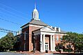
Carroll County Courthouse in Westminster
-
Flag of Carroll County
-
Seal of Carroll County
See also
 In Spanish: Condado de Carroll (Maryland) para niños
