York County, Pennsylvania facts for kids
Quick facts for kids
York County
|
||
|---|---|---|
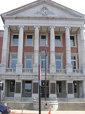
York County Administrative Center in York, Pennsylvania
|
||
|
||
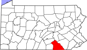
Location within the U.S. state of Pennsylvania
|
||
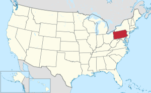 Pennsylvania's location within the U.S. |
||
| Country | ||
| State | ||
| Founded | August 19, 1749 | |
| Named for | Duke of York | |
| Seat | York | |
| Largest city | York | |
| Area | ||
| • Total | 911 sq mi (2,360 km2) | |
| • Land | 904 sq mi (2,340 km2) | |
| • Water | 6.5 sq mi (17 km2) 0.7%% | |
| Population
(2020)
|
||
| • Total | 456,438 | |
| • Density | 481.1/sq mi (185.8/km2) | |
| Time zone | UTC−5 (Eastern) | |
| • Summer (DST) | UTC−4 (EDT) | |
| Congressional districts | 10th, 11th | |
York County is a county in Pennsylvania, United States. A county is like a large area of land with its own local government. In 2020, about 456,438 people lived here.
The main town, or county seat, is York. The county was started on August 19, 1749. It was formed from a part of Lancaster County. It might have been named after the Duke of York. He was an early supporter of the Penn family. Or, it could be named after the city and county of York in England. York County is in the South Central part of Pennsylvania.
York County is part of the York-Hanover area. This area is also connected to the larger Harrisburg-York-Lebanon region. It is located in the Susquehanna Valley. This valley is a large, rich farming area in South Central Pennsylvania.
Some people believe York was the first capital of the United States. This is because the Articles of Confederation were adopted here in 1777. Historians still discuss this idea. York and Wrightsville were even considered as the permanent capital. But later, Washington, D.C. was chosen.
York County is home to many well-known companies. These include Martin's Potato Chips and Utz Quality Foods, Inc.. You can also find Snyder's of Hanover and Hanover Foods here. Other famous businesses are Wolfgang Candy and a big Harley-Davidson Motor Company factory. York International (for cooling equipment) and York Barbell are also in the county.
Contents
Exploring York County's Geography
York County covers about 911 square miles. Most of this is land (904 square miles). Only a small part (6.5 square miles) is water. The Susquehanna River forms the eastern border of the county. To the south, the Mason–Dixon line separates Pennsylvania from Maryland.
York County is generally hilly. It rises towards the Blue Ridge Mountains in the northwest. Here, it is bordered by Yellow Breeches Creek. Inside the county, there are rivers like Codorus and Conewago Creek. There are also several lakes, including Lehman, Kiwanis, Marburg, and Pinchot.
Neighboring Counties
York County shares borders with these other counties:
- Cumberland County (north)
- Dauphin County (northeast)
- Lancaster County (east)
- Harford County, Maryland (southeast)
- Baltimore County, Maryland (south)
- Carroll County, Maryland (southwest)
- Adams County (west)
Main Roads and Highways

 I-76 / Penna Turnpike
 I-83
I-83 I‑83 Bus.
 US 15
US 15 US 30
US 30 PA 24
PA 24 PA 74
PA 74 PA 94
PA 94 PA 114
 PA 116
 PA 124
 PA 177
 PA 181
 PA 182
 PA 194
 PA 214
 PA 216
 PA 234
 PA 238
 PA 262
 PA 297
 PA 372
 PA 382
 PA 392
 PA 425
 PA 462
 PA 516
 PA 616
 PA 624
 PA 851
 PA 921
York County's Climate
Most of York County has a climate with hot summers. This is called a humid continental climate. Some lower areas in the east have a humid subtropical climate. This means they have warm, humid summers and mild winters.
| Climate data for York, Pennsylvania (1991-2020 normals) | |||||||||||||
|---|---|---|---|---|---|---|---|---|---|---|---|---|---|
| Month | Jan | Feb | Mar | Apr | May | Jun | Jul | Aug | Sep | Oct | Nov | Dec | Year |
| Mean daily maximum °F (°C) | 41.2 (5.1) |
45.3 (7.4) |
54.5 (12.5) |
67.2 (19.6) |
76.5 (24.7) |
83.9 (28.8) |
87.7 (30.9) |
86.0 (30.0) |
79.7 (26.5) |
68.2 (20.1) |
55.7 (13.2) |
44.9 (7.2) |
65.9 (18.8) |
| Daily mean °F (°C) | 31.2 (−0.4) |
34.3 (1.3) |
42.4 (5.8) |
53.6 (12.0) |
63.1 (17.3) |
71.2 (21.8) |
75.4 (24.1) |
73.8 (23.2) |
67.1 (19.5) |
55.6 (13.1) |
44.4 (6.9) |
35.5 (1.9) |
54.0 (12.2) |
| Mean daily minimum °F (°C) | 21.3 (−5.9) |
23.2 (−4.9) |
30.2 (−1.0) |
40.0 (4.4) |
49.7 (9.8) |
58.5 (14.7) |
63.1 (17.3) |
61.5 (16.4) |
54.5 (12.5) |
43.0 (6.1) |
33.1 (0.6) |
26.1 (−3.3) |
42.0 (5.6) |
| Average precipitation inches (mm) | 3.27 (83) |
2.81 (71) |
4.01 (102) |
3.62 (92) |
4.20 (107) |
4.29 (109) |
4.52 (115) |
3.96 (101) |
5.10 (130) |
3.94 (100) |
3.22 (82) |
3.52 (89) |
46.46 (1,180) |
| Average snowfall inches (cm) | 8.5 (22) |
8.2 (21) |
3.9 (9.9) |
0.2 (0.51) |
0.0 (0.0) |
0.0 (0.0) |
0.0 (0.0) |
0.0 (0.0) |
0.0 (0.0) |
0.0 (0.0) |
0.5 (1.3) |
3.3 (8.4) |
24.6 (62) |
| Average precipitation days (≥ 0.01 in) | 10.3 | 9.6 | 11.6 | 11.6 | 12.7 | 12.0 | 11.0 | 9.6 | 9.6 | 8.4 | 10.0 | 10.5 | 126.9 |
| Average snowy days (≥ 0.1 in) | 3.3 | 3.0 | 1.7 | 0.2 | 0.0 | 0.0 | 0.0 | 0.0 | 0.0 | 0.0 | 0.3 | 1.5 | 10.0 |
| Source: NOAA | |||||||||||||
People and Population of York County
| Historical population | |||
|---|---|---|---|
| Census | Pop. | %± | |
| 1790 | 37,535 | — | |
| 1800 | 25,643 | −31.7% | |
| 1810 | 31,958 | 24.6% | |
| 1820 | 38,759 | 21.3% | |
| 1830 | 42,859 | 10.6% | |
| 1840 | 47,010 | 9.7% | |
| 1850 | 57,450 | 22.2% | |
| 1860 | 68,200 | 18.7% | |
| 1870 | 76,134 | 11.6% | |
| 1880 | 87,841 | 15.4% | |
| 1890 | 99,489 | 13.3% | |
| 1900 | 116,413 | 17.0% | |
| 1910 | 136,405 | 17.2% | |
| 1920 | 144,521 | 5.9% | |
| 1930 | 167,135 | 15.6% | |
| 1940 | 178,022 | 6.5% | |
| 1950 | 202,737 | 13.9% | |
| 1960 | 238,336 | 17.6% | |
| 1970 | 272,603 | 14.4% | |
| 1980 | 312,963 | 14.8% | |
| 1990 | 339,574 | 8.5% | |
| 2000 | 381,751 | 12.4% | |
| 2010 | 434,972 | 13.9% | |
| 2020 | 456,438 | 4.9% | |
| U.S. Decennial Census 1790–1960 1900–1990 1990–2000 2010–2019 |
|||
In 2000, there were 381,751 people living in York County. There were about 148,219 households. A household is a group of people living in one home. The county had about 422 people per square mile.
Most people (92.76%) were White. About 3.69% were African American. Around 2.96% of the population were Hispanic or Latino. Many people had German (42.0%) or Irish (7.7%) backgrounds. Most people (94.8%) spoke English at home.
About 32.50% of households had children under 18. The average household had 2.52 people. The average family had 2.98 people. The population was spread out by age. About 24.60% were under 18 years old. The average age was 38 years.
Between 2000 and 2006, the York-Hanover area grew quickly. It was one of the fastest-growing areas in the Northeast. The number of Hispanic or Latino residents in York city also grew a lot between 2000 and 2010.
2020 Census Information
Here is a breakdown of the different groups of people in York County from the 2020 census:
| Race | Num. | Perc. |
|---|---|---|
| White (NH) | 365,353 | 80% |
| Black or African American (NH) | 25,768 | 5.64% |
| Native American (NH) | 640 | 0.14% |
| Asian (NH) | 6,557 | 1.43% |
| Pacific Islander (NH) | 118 | 0.03% |
| Other/mixed (NH) | 18,642 | 4.1% |
| Hispanic or Latino | 39,360 | 8.62% |
Local Dialects and Accents
In York County, you might hear the Central Pennsylvania accent. This is a way of speaking common in the area. Many people also have Pennsylvania Dutch backgrounds. They often speak with a special Pennsylvania Dutch English accent.
Understanding Metropolitan Areas
The U.S. government calls York County the York–Hanover, PA metropolitan statistical area (MSA). This means it's a large city area and its nearby communities that are closely connected. In 2012, it was the 9th biggest MSA in Pennsylvania.
York–Hanover is also part of an even bigger area. This is called the Harrisburg–York–Lebanon combined statistical area (CSA). A CSA connects several MSAs that are close to each other. In 2017, this larger area had about 1.26 million people. It was the 5th largest CSA in Pennsylvania.
Education in York County
York County has many schools for students of all ages.
Public School Districts
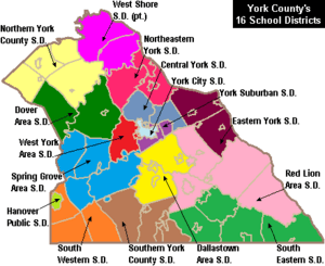
These are the public school districts in York County:
- Central York School District
- Dallastown Area School District
- Dover Area School District
- Eastern York School District
- Hanover Public School District
- Northeastern York School District
- Northern York County School District
- Red Lion Area School District
- South Eastern School District
- South Western School District
- Southern York County School District
- Spring Grove Area School District
- West Shore School District
- West York Area School District
- York City School District
- York Suburban School District
Vocational Schools
- York County School of Technology - This school helps students learn job skills.
Public Charter Schools
Charter schools are public schools that have more freedom in how they operate.
- Crispus Attucks Youthbuild Charter School (Grades K–6) – York
- Helen Thackston Charter School (Grades 6–12) – York
- Lincoln Charter School (Grades K–5) – York
- New Hope Academy Charter School (Grades K–6) – York
- York Academy Regional Charter School
- York Adams Academy (formerly York County High School)
Independent Schools
These are private schools in York County:
- Christian School of York (PreK–12)
- Keystone Christian Academy York (K–8)
- Logos Academy York (K–12)
- St. Joseph School Hanover (PreK–8)
- St. Joseph School (PreK–6)
- St. John the Baptist Catholic School New Freedom (PreK–6)
- Shrewsbury Christian Academy New Freedom (PreK–8)
- Tidings of Peace Christian School York (K–12)
- York Catholic High School (7–12)
- York Country Day School (PreK–12)
Intermediate Unit (IU#12)
The Lincoln Intermediate Unit (IU#12) helps schools in York, Adams, and Franklin counties. It provides services like special education and help with technology. It also runs a Summer Academy for talented students. The IU helps adults earn a high school diploma through a GED program.
Colleges and Universities
- Pennsylvania State University, Penn State York campus
- Harrisburg Area Community College – York Campus
- York College of Pennsylvania
- YTI Career Institute (YTI = York Technical Institute)
Adult Education Programs
- YTI Career Institute
- Motorcycle Technology Center
- York Time Institute
Communities of York County
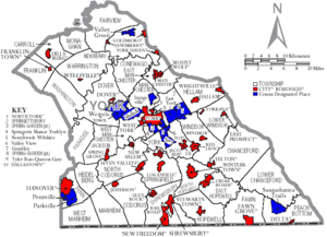
In Pennsylvania, there are four main types of towns and cities: cities, boroughs, townships, and one special case called a "town." York County has 72 of these different communities.
City
- York (This is the county seat, the main town.)
Boroughs
Boroughs are smaller towns with their own local governments.
- Cross Roads
- Dallastown
- Delta
- Dillsburg
- Dover
- East Prospect
- Fawn Grove
- Felton
- Franklintown
- Glen Rock
- Goldsboro
- Hallam
- Hanover
- Jacobus
- Jefferson
- Lewisberry
- Loganville
- Manchester
- Mount Wolf
- New Freedom
- New Salem
- North York
- Railroad
- Red Lion
- Seven Valleys
- Shrewsbury
- Spring Grove
- Stewartstown
- Wellsville
- West York
- Windsor
- Winterstown
- Wrightsville
- Yoe
- York Haven
- Yorkana
Townships
Townships are areas of land that are usually larger than boroughs and often include rural areas.
- Carroll
- Chanceford
- Codorus
- Conewago
- Dover
- East Hopewell
- East Manchester
- Fairview
- Fawn
- Franklin
- Heidelberg
- Hellam
- Hopewell
- Jackson
- Lower Chanceford
- Lower Windsor
- Manchester
- Manheim
- Monaghan
- Newberry
- North Codorus
- North Hopewell
- Paradise
- Peach Bottom
- Penn
- Shrewsbury
- Spring Garden
- Springettsbury
- Springfield
- Warrington
- Washington
- West Manchester
- West Manheim
- Windsor
- York
Census-Designated Places (CDPs)
CDPs are areas that the U.S. Census Bureau names for collecting population data. They are not officially governed towns.
Other Unincorporated Communities
These are other small communities in York County that do not have their own local governments.
- Accomac
- Admire
- Airville
- Ambau
- Andersontown
- Bandanna
- Bermudian
- Big Mountain
- Blackrock
- Bridgeville
- Brogue
- Bryansville
- Cly
- Craley
- Codorus Furnace
- Conewago Heights
- Davidsburg
- Detters Mill
- Etters
- Fayfield
- Fireside Terrace
- Foustown
- Fuhrmans Mill
- Gatchellville
- Glades
- Glenville
- Gnatstown
- Hametown
- Hanover Junction
- Hopewell Center
- Kralltown
- Leaders Heights
- Leibharts Corner
- Lockport (under Lake Clarke)
- Mackey Ford
- Mount Royal
- Muddy Creek Forks
- New Bridgeville
- New Park
- Nauvoo
- Ore Valley
- Porters Sideling
- Reesers Summit
- Rossville
- Saginaw
- Shenks Ferry
- Siddonsburg
- Spring Forge
- Starview
- Stoverstown
- Strickler
- Strinestown
- Sunnyburn
- Thomasville
- Tolna
- Valley Forge
- Violet Hill
- Wago Junction
- Woodbine
- Yocumtown
- York Furnace
Community Population Ranking
This table shows the communities in York County ranked by their population in 2010.
† county seat
| Rank | City/town/etc. | Municipal type | Population (2010 Census) |
|---|---|---|---|
| 1 | † York | City | 43,718 |
| 2 | Hanover | Borough | 15,289 |
| 3 | Weigelstown | CDP | 12,875 |
| 4 | Shiloh | CDP | 11,218 |
| 5 | East York | CDP | 8,777 |
| 6 | Parkville | CDP | 6,706 |
| 7 | Red Lion | Borough | 6,373 |
| 8 | Spry | CDP | 4,891 |
| 9 | West York | Borough | 4,617 |
| 10 | New Freedom | Borough | 4,464 |
| 11 | Dallastown | Borough | 4,049 |
| 12 | Shrewsbury | Borough | 3,823 |
| 13 | Grantley | CDP | 3,628 |
| 14 | Valley Green | CDP | 3,429 |
| 15 | Valley View | CDP | 2,817 |
| 16 | Manchester | Borough | 2,763 |
| 17 | Hallam | Borough | 2,673 |
| 18 | Emigsville | CDP | 2,672 |
| 19 | Dillsburg | Borough | 2,563 |
| 20 | Stonybrook | CDP | 2,384 |
| 21 | Wrightsville | Borough | 2,310 |
| 22 | Susquehanna Trails | CDP | 2,264 |
| 23 | Spring Grove | Borough | 2,167 |
| 24 | Stewartstown | Borough | 2,089 |
| 25 | Glen Rock | Borough | 2,025 |
| 26 | Dover | Borough | 2,007 |
| 27 | Pennville | CDP | 1,947 |
| 28 | North York | Borough | 1,914 |
| 29 | Yorklyn | CDP | 1,912 |
| 30 | Tyler Run | CDP | 1,901 |
| 31 | Jacobus | Borough | 1,841 |
| 32 | Queens Gate | CDP | 1,464 |
| 33 | Mount Wolf | Borough | 1,393 |
| 34 | Windsor | Borough | 1,319 |
| 35 | Loganville | Borough | 1,240 |
| 36 | Yoe | Borough | 1,018 |
| 37 | Goldsboro | Borough | 952 |
| 38 | East Prospect | Borough | 905 |
| 39 | New Market | CDP | 816 |
| 40 | Jefferson | Borough | 733 |
| 41 | Delta | Borough | 728 |
| 42 | York Haven | Borough | 709 |
| 43 | Winterstown | Borough | 632 |
| 44 | New Salem | Borough | 579 |
| 45 | Seven Valleys | Borough | 517 |
| 46 | Cross Roads | Borough | 512 |
| 47 | Felton | Borough | 506 |
| 48 | Franklintown | Borough | 489 |
| 49 | Fawn Grove | Borough | 452 |
| 50 | Lewisberry | Borough | 362 |
| 51 | Railroad | Borough | 278 |
| 52 | Wellsville | Borough | 242 |
| 53 | Yorkana | Borough | 229 |
Airports in the Area
York County does not have regular passenger flights. But it does have two airports for smaller planes. These are Capital City Airport and York Airport. The county works with other nearby counties to manage airports. The closest airports with passenger service are Harrisburg International Airport, Lancaster County Airport, and BWI.
Famous People from York County
Many interesting people have come from York County:
- John Andrews, a U.S. Navy sailor who won the Medal of Honor.
- Jacob L. Devers, a four-star general in World War II.
- Hali Flickinger, an Olympic swimmer.
- Halestorm, a rock band from Red Lion.
- Mike Hawthorne, a comic book artist.
- Bob Hoffman, who started York Barbell and was called the "Father of World Weightlifting."
- Brian Keene, a best-selling writer.
- Jeff Koons, a famous artist and sculptor.
- John Kuhn, an NFL football player.
- George M. Leader, a former governor of Pennsylvania.
- Live, a popular rock band from the 1990s.
- Ken Ludwig, a playwright and theater director.
- Del McCoury, a Grammy-winning bluegrass musician.
- Cameron Mitchell, an actor.
- Todd Platts, a judge and former member of the U.S. House of Representatives.
- H. B. Reese, the inventor of Reese's Peanut Butter Cups.
- Evan Sharp, co-founder of Pinterest.
- Jimmy Sheckard, an MLB player who won the World Series twice.
- Craig Sheffer, an actor.
- Jarace Walker, an NBA basketball player.
- Tom Wolf, a former governor of Pennsylvania.
See also
 In Spanish: Condado de York (Pensilvania) para niños
 | Mary Eliza Mahoney |
 | Susie King Taylor |
 | Ida Gray |
 | Eliza Ann Grier |


