Shrewsbury, Pennsylvania facts for kids
Quick facts for kids
Shrewsbury, Pennsylvania
|
|
|---|---|
|
Borough
|
|

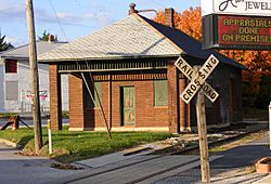
Stewartstown Railroad Rail station at Shrewsbury
|
|

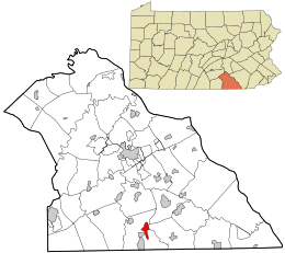
Location in York County and the U.S. state of Pennsylvania.
|
|
| Country | United States |
| State | Pennsylvania |
| County | York |
| Settled | 1800 |
| Incorporated | 1834 |
| Government | |
| • Type | Borough Council |
| Area | |
| • Total | 1.81 sq mi (4.68 km2) |
| • Land | 1.81 sq mi (4.68 km2) |
| • Water | 0.00 sq mi (0.00 km2) |
| Elevation | 994 ft (303 m) |
| Population
(2020)
|
|
| • Total | 3,848 |
| • Estimate
(2021)
|
3,845 |
| • Density | 2,132.19/sq mi (823.39/km2) |
| Time zone | UTC-5 (Eastern (EST)) |
| • Summer (DST) | UTC-4 (EDT) |
| ZIP Code |
17361
|
| Area code(s) | 717 |
| FIPS code | 42-70568 |
Shrewsbury is a small town, also called a borough, located in York County, Pennsylvania. In 2020, about 3,848 people lived there. It is part of the larger York–Hanover metropolitan area.
Shrewsbury is next to a larger area called Shrewsbury Township. Other nearby towns include New Freedom and Glen Rock.
Contents
History of Shrewsbury
At one time, the land where Shrewsbury Borough is now was part of a much larger area called Shrewsbury Township.
How Shrewsbury Started
In 1797, a person named Baltzer Faust started to develop the village. He created lots for homes and businesses along Joppa Road. This road later became the York-Baltimore Turnpike and is now Main Street.
The first people to settle here were mostly German. They called the town Strassburg, which means "the town by the street or road."
Changing the Name
By 1830, many English people had moved to the area. Because of this, the town's official name was changed back to "Shrewsbury."
On August 9, 1834, Shrewsbury officially became a borough. This happened through a special law passed by the General Assembly. The new borough was about one mile long and half a mile wide. It stretched along the main turnpike, with the town center at the crossroads.
The Shrewsbury Historic District was added to the National Register of Historic Places in 1984. This means it's an important historical area.
Geography of Shrewsbury
Shrewsbury is located at 39°46′2″N 76°40′44″W / 39.76722°N 76.67889°W.
The United States Census Bureau says that the borough covers a total area of about 1.8 square miles (4.68 square kilometers). All of this area is land, with no large bodies of water.
Population and People
| Historical population | |||
|---|---|---|---|
| Census | Pop. | %± | |
| 1840 | 340 | — | |
| 1850 | 472 | 38.8% | |
| 1860 | 552 | 16.9% | |
| 1870 | 600 | 8.7% | |
| 1880 | 565 | −5.8% | |
| 1890 | 562 | −0.5% | |
| 1900 | 554 | −1.4% | |
| 1910 | 598 | 7.9% | |
| 1920 | 568 | −5.0% | |
| 1930 | 671 | 18.1% | |
| 1940 | 720 | 7.3% | |
| 1950 | 787 | 9.3% | |
| 1960 | 943 | 19.8% | |
| 1970 | 1,716 | 82.0% | |
| 1980 | 2,688 | 56.6% | |
| 1990 | 2,672 | −0.6% | |
| 2000 | 3,378 | 26.4% | |
| 2010 | 3,823 | 13.2% | |
| 2020 | 3,848 | 0.7% | |
| 2021 (est.) | 3,845 | 0.6% | |
| Sources: | |||
Population Numbers
According to the census from 2000, there were 3,378 people living in Shrewsbury. These people made up 1,330 households and 942 families.
The population density was about 1,916 people per square mile (740 people per square kilometer). There were 1,367 housing units in the borough.
Diversity in Shrewsbury
Most of the people living in Shrewsbury in 2000 were White (97.48%). Other groups included African American (0.80%), Native American (0.15%), and Asian (0.77%). A small number of people were Hispanic or Latino (0.98%).
Households and Families
Out of the 1,330 households, about 32.3% had children under 18 living with them. Most households (61.4%) were married couples living together. About 26.1% of all households were made up of people living alone.
The average household had 2.54 people. The average family had 3.08 people.
Age Groups
The population of Shrewsbury was spread out across different age groups:
- 25.7% were under 18 years old.
- 6.0% were between 18 and 24 years old.
- 28.5% were between 25 and 44 years old.
- 26.2% were between 45 and 64 years old.
- 13.6% were 65 years or older.
The median age in Shrewsbury was 40 years. This means half the people were younger than 40 and half were older.
Income Information
In 2000, the median income for a household in Shrewsbury was $49,983. For a family, the median income was $57,358. The per capita income for the borough was $20,292.
About 4.7% of the total population lived below the poverty line. This included 1.5% of those under 18 and 15.2% of those aged 65 or older.
Education in Shrewsbury
Shrewsbury is part of the Southern York County School District. This district includes several schools:
- Shrewsbury Elementary School
- Southern Middle School
- Susquehannock High School
The town also has a public library called the Paul Smith Library of Southern York County.
See also
 In Spanish: Shrewsbury (Pensilvania) para niños
 | Jessica Watkins |
 | Robert Henry Lawrence Jr. |
 | Mae Jemison |
 | Sian Proctor |
 | Guion Bluford |


