Railroad, Pennsylvania facts for kids
Quick facts for kids
Railroad, Pennsylvania
|
|
|---|---|
|
Borough
|
|
 |
|

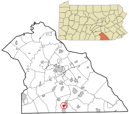
Location in York County and the U.S. state of Pennsylvania.
|
|
| Country | United States |
| State | Pennsylvania |
| County | York |
| Settled | 1792 |
| Incorporated | 1871 |
| Government | |
| • Type | Borough Council |
| Area | |
| • Total | 0.64 sq mi (1.65 km2) |
| • Land | 0.64 sq mi (1.65 km2) |
| • Water | 0.00 sq mi (0.00 km2) |
| Elevation | 804 ft (245 m) |
| Population
(2020)
|
|
| • Total | 256 |
| • Density | 401.25/sq mi (154.86/km2) |
| Time zone | UTC-5 (Eastern (EST)) |
| • Summer (DST) | UTC-4 (EDT) |
| Zip code |
17355
|
| Area code(s) | 717 |
| FIPS code | 42-63288 |
Railroad is a small town, also known as a borough, located in York County, Pennsylvania, United States. In 2020, about 259 people lived there. It is part of the larger York–Hanover metropolitan area.
History of Railroad Borough
The town of Railroad got its name and its start because of a very important railway. This railway was built to connect two big cities: Baltimore, Maryland and Harrisburg, Pennsylvania. It later became known as the Northern Central Railway.
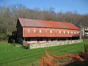
In 1984, a special part of Railroad, called the Railroad Borough Historic District, was added to the National Register of Historic Places. This means it's a place with important history that should be protected. One writer, Laura Randall, described Railroad as a "tiny town" near the Maryland border. She noted it had a bed and breakfast and a popular crab shack.
Geography and Location
Railroad is located in Pennsylvania at specific coordinates: 39 degrees, 45 minutes, 24 seconds North and 76 degrees, 41 minutes, 58 seconds West.
The United States Census Bureau says that the borough covers a total area of about 0.64 square miles (which is about 1.65 square kilometers). All of this area is land.
Population and People
| Historical population | |||
|---|---|---|---|
| Census | Pop. | %± | |
| 1880 | 220 | — | |
| 1890 | 201 | −8.6% | |
| 1900 | 213 | 6.0% | |
| 1910 | 308 | 44.6% | |
| 1920 | 310 | 0.6% | |
| 1930 | 268 | −13.5% | |
| 1940 | 279 | 4.1% | |
| 1950 | 300 | 7.5% | |
| 1960 | 273 | −9.0% | |
| 1970 | 308 | 12.8% | |
| 1980 | 272 | −11.7% | |
| 1990 | 317 | 16.5% | |
| 2000 | 300 | −5.4% | |
| 2010 | 278 | −7.3% | |
| 2020 | 259 | −6.8% | |
| 2021 (est.) | 258 | −7.2% | |
| Sources: | |||
In the year 2000, there were 300 people living in Railroad. These people lived in 112 households, and 79 of these were families.
The population density was about 478.7 people per square mile (or 185.1 people per square kilometer). There were 116 housing units in the borough.
Many households in Railroad had children under 18 living with them. The average household had about 2.68 people. The average family size was about 3.16 people.
The median age of people in Railroad was 36 years old. This means half the people were younger than 36, and half were older.
See also

- In Spanish: Railroad (Pensilvania) para niños
 | Bessie Coleman |
 | Spann Watson |
 | Jill E. Brown |
 | Sherman W. White |


