Harrisburg–York–Lebanon combined statistical area facts for kids
Quick facts for kids
Harrisburg–York–Lebanon, PA CSA
|
|
|---|---|
|
Combined statistical area
|
|

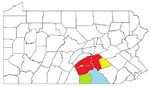
Map of the Harrisburg–York–Lebanon, PA combined statistical area (CSA), composed of the following parts:
Harrisburg–Carlisle metropolitan statistical area (MSA) Lebanon, PA metropolitan statistical area (MSA) Gettysburg, PA metropolitan statistical aea (MSA) York-Hanover, PA metropolitan statistical area (MSA) |
|
| Country | |
| State | |
| Principal cities | Harrisburg York Lebanon Carlisle Hanover Gettysburg |
| Area | |
| • Total | 8,959 km2 (3,459.1 sq mi) |
| Population
(2010 est.)
|
|
| • Total | 1,219,422 |
| • Density | 136.1/km2 (352.5/sq mi) |
| Time zone | UTC-5 (ET) |
| • Summer (DST) | UTC-4 (EDT) |
The Harrisburg–York–Lebanon, PA combined statistical area (CSA) is a special region in Pennsylvania. The U.S. government uses this term to group together nearby cities and counties. This helps them understand how many people live and work in these connected areas.
This CSA includes important cities like Harrisburg, York, and Lebanon. It also covers several metropolitan statistical areas. In 2010, about 1,219,422 people lived here. This made it the third largest CSA in Pennsylvania and the 43rd largest in the entire United States.
Contents
What Makes Up This Area?
A Combined Statistical Area (CSA) is like a big neighborhood made of smaller "Metropolitan Statistical Areas" (MSAs). Think of it as a collection of cities and their surrounding towns that are all connected by people traveling for work or school.
Harrisburg–Carlisle Area
This MSA includes three counties:
- Cumberland County with about 235,406 people.
- Dauphin County with about 268,100 people.
- Perry County with about 45,969 people.
Lebanon Area
This MSA is made up of:
- Lebanon County with about 133,568 people.
Gettysburg Area
This MSA includes:
- Adams County with about 101,407 people.
York–Hanover Area
This MSA covers:
- York County with about 434,972 people.
Who Lives Here?
In 2000, there were over 629,401 people living in this combined area. They lived in about 248,931 households. A household means all the people living in one home. About 167,328 of these were families.
Most people in the area were White (about 87.78%). About 7.84% were African American. Around 1.53% were Asian, and 0.14% were Native American. A small number (3.11%) identified as Hispanic or Latino.
 | Percy Lavon Julian |
 | Katherine Johnson |
 | George Washington Carver |
 | Annie Easley |


