Lebanon County, Pennsylvania facts for kids
Quick facts for kids
Lebanon County
|
||
|---|---|---|
|
||
|
||
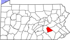
Location within the U.S. state of Pennsylvania
|
||
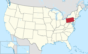 Pennsylvania's location within the U.S. |
||
| Country | ||
| State | ||
| Founded | February 16, 1813 | |
| Seat | Lebanon | |
| Largest city | Lebanon | |
| Area | ||
| • Total | 362 sq mi (940 km2) | |
| • Land | 362 sq mi (940 km2) | |
| • Water | 0.7 sq mi (2 km2) 0.2% | |
| Population | ||
| • Estimate
(2020)
|
143,257 | |
| • Density | 390/sq mi (150/km2) | |
| Time zone | UTC−5 (Eastern) | |
| • Summer (DST) | UTC−4 (EDT) | |
| Congressional district | 9th | |
Lebanon County is a county in Pennsylvania, United States. In 2020, about 143,257 people lived there. The main city and county seat is Lebanon. It is located about 72 miles northwest of Philadelphia. This makes it part of the South Central Pennsylvania region.
Lebanon County was created in 1813. It was formed from parts of Dauphin and Lancaster counties. A few small changes were made to its borders in 1814 and 1821. Lebanon County is also part of a larger area called the Harrisburg–York–Lebanon combined statistical area.
Contents
Geography of Lebanon County
Lebanon County covers about 362 square miles. Most of this area is land, with only a small amount of water. The county's rivers and streams mostly flow into the Susquehanna River. Some eastern parts drain into the Schuylkill River. The county is mostly a valley.
Climate and Weather
Lebanon County has a humid continental climate. This means it has warm, humid summers and cold winters. The average temperature in January is around 29.4°F. In July, it's about 74.3°F.
Neighboring Counties
Lebanon County shares its borders with these other counties:
- Schuylkill County (to the north)
- Berks County (to the east)
- Lancaster County (to the south)
- Dauphin County (to the west)
Main Roads and Highways
Many important roads pass through Lebanon County. These highways help people travel around the county and to other parts of Pennsylvania.

 I-76 / Penna Turnpike
 I-78
I-78 I-81
I-81 US 22
US 22 US 322
 US 422
 PA 72
PA 72 PA 117
 PA 241
 PA 341
 PA 343
 PA 419
 PA 443
 PA 501
 PA 645
 PA 897
 PA 934
People of Lebanon County
| Historical population | |||
|---|---|---|---|
| Census | Pop. | %± | |
| 1820 | 16,988 | — | |
| 1830 | 20,557 | 21.0% | |
| 1840 | 21,872 | 6.4% | |
| 1850 | 26,071 | 19.2% | |
| 1860 | 31,831 | 22.1% | |
| 1870 | 34,096 | 7.1% | |
| 1880 | 38,476 | 12.8% | |
| 1890 | 48,131 | 25.1% | |
| 1900 | 53,827 | 11.8% | |
| 1910 | 59,565 | 10.7% | |
| 1920 | 63,152 | 6.0% | |
| 1930 | 67,103 | 6.3% | |
| 1940 | 72,641 | 8.3% | |
| 1950 | 81,683 | 12.4% | |
| 1960 | 90,853 | 11.2% | |
| 1970 | 99,665 | 9.7% | |
| 1980 | 108,582 | 8.9% | |
| 1990 | 113,744 | 4.8% | |
| 2000 | 120,327 | 5.8% | |
| 2010 | 133,568 | 11.0% | |
| 2020 | 143,257 | 7.3% | |
| U.S. Decennial Census 1790-1960 1900-1990 1990-2000 2010-2019 |
|||
In 2000, there were 120,327 people living in Lebanon County. The population density was about 332 people per square mile. Most people (94.46%) were White. About 4.96% of the population were Hispanic or Latino. Many people in the county have German roots (45.6%). Most people speak English (92.5%). Some also speak Spanish (4.2%) or Pennsylvania Dutch (1.1%).
About 23.70% of the people were under 18 years old. The average age was 39 years. For every 100 females, there were about 95 males.
2020 Census Information
The 2020 census showed the following breakdown of people in Lebanon County:
| Race | Number | Percent |
|---|---|---|
| White (not Hispanic) | 114,004 | 79.6% |
| Black or African American (not Hispanic) | 2,555 | 1.8% |
| Native American (not Hispanic) | 119 | 0.1% |
| Asian (not Hispanic) | 2,192 | 1.53% |
| Pacific Islander (not Hispanic) | 39 | 0.03% |
| Other/mixed (not Hispanic) | 4,000 | 2.8% |
| Hispanic or Latino | 20,348 | 14.2% |
Metropolitan Area
Lebanon County is its own "metropolitan statistical area" (MSA). This means it's a region with a large population and close economic ties. In 2010, it was the 16th most populated MSA in Pennsylvania.
Lebanon County is also part of a bigger area called the Harrisburg–York–Lebanon combined statistical area (CSA). This larger area includes several other counties: Adams, Cumberland, Dauphin, Perry, and York counties. This combined area is the 5th largest in Pennsylvania.
Education in Lebanon County
Lebanon County has several places for learning, from colleges to public schools.
Colleges and Universities
- Harrisburg Area Community College (Lebanon Campus)
- Lebanon Valley College
- Evangelical Seminary
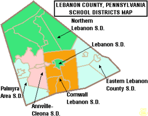
Public School Districts
These are the public school districts that serve students in Lebanon County:
- Annville-Cleona School District
- Cornwall-Lebanon School District
- Eastern Lebanon County School District
- Lebanon School District
- Northern Lebanon School District
- Palmyra Area School District
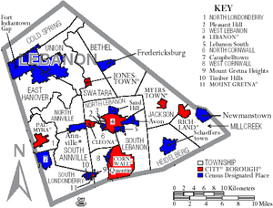
Communities in Lebanon County
In Pennsylvania, there are different types of local governments. These include cities, boroughs, and townships. Here are the communities found in Lebanon County:
City
- Lebanon (This is the county seat, where the main county government offices are.)
Boroughs
Boroughs are smaller towns with their own local governments.
Townships
Townships are areas of land that include smaller communities or rural areas.
- Annville
- Bethel
- Cold Spring
- East Hanover
- Heidelberg
- Jackson
- Millcreek
- North Annville
- North Cornwall
- North Lebanon
- North Londonderry
- South Annville
- South Lebanon
- South Londonderry
- Swatara
- Union
- West Cornwall
- West Lebanon
Census-Designated Places (CDPs)
These are special areas defined by the U.S. Census Bureau for collecting data. They are not official towns or cities.
Other Small Communities
Lebanon County also has many other small, unincorporated communities.
- Anthracite
- Bellegrove
- Beverly Heights
- Bordnersville
- Buffalo Springs
- Bunker Hill
- Canaan Grove
- Clear Spring
- Coffeetown
- Colebrook
- Coheva
- Dogtown
- East Hanover
- Ebenezer
- Edisonville
- Eustontown
- Flintville
- Fontana
- Freeport Mills
- Gold Mine
- Gravel Hill
- Greble
- Green Point
- Hamlin
- Harper Tavern
- Hauckville
- Heilmandale
- Indiantown
- Inwood
- Iona
- Johnstown
- Kleinfeltersville
- Kutztown
- Lawn
- Lickdale
- McGillstown
- Midway
- Millardsville
- Millbach
- Millbach Springs
- Mount Ararat
- Mount Pleasant
- Mount Wilson
- Mount Zion
- Murray
- Nacetown
- Ono
- Pansy Hill
- Plainville
- Prescott
- Reinoeldville
- Reistville
- Rocherty
- Rockwood
- Sheridan
- Shirksville
- Springhaven
- Stricklerstown
- Syner
- Union Water Works
- Upper Lawn
- Valley Glenn
- Waldeck
- Weavertown, Jackson Township
- Weavertown, North Lebanon Township
- West Jonestown
- Westmont
- Woodfort
- Zinns Mill
Ghost Towns
These are places that used to be communities but are now abandoned.
- Cold Spring
- Rausch Gap
Largest Communities by Population
This table shows the communities in Lebanon County ranked by their population in 2010. † county seat
| Rank | City/town/etc. | Type | Population (2010 Census) |
|---|---|---|---|
| 1 | † Lebanon | City | 25,477 |
| 2 | Palmyra | Borough | 7,320 |
| 3 | Annville (township) | CDP | 4,767 |
| 4 | Cornwall | Borough | 4,112 |
| 5 | Campbelltown | CDP | 3,616 |
| 6 | Myerstown | Borough | 3,062 |
| 7 | Pleasant Hill | CDP | 2,643 |
| 8 | Sand Hill | CDP | 2,496 |
| 9 | Newmanstown | CDP | 2,478 |
| 10 | Lebanon South | CDP | 2,270 |
| 11 | Cleona | Borough | 2,080 |
| 12 | Jonestown | Borough | 1,905 |
| 13 | Avon | CDP | 1,667 |
| 14 | Richland | Borough | 1,519 |
| 15 | Fredericksburg | CDP | 1,357 |
| 16 | Hebron | CDP | 1,305 |
| 17 | Schaefferstown | CDP | 941 |
| 18 | Quentin | CDP | 594 |
| 19 | Timber Hills | CDP | 360 |
| 20 | Mount Gretna Heights | CDP | 323 |
| 21 | Mount Gretna | Borough | 196 |
| 22 | Fort Indiantown Gap | CDP | 143 |
Parks and Fun Places
Lebanon County has many parks and recreational spots where people can enjoy nature and outdoor activities.
- Memorial Lake State Park
- Swatara State Park
- Union Canal Tunnel Park
- Lions Lake Park
- Coleman's Memorial Park
- Stoever's Dam Park
- South Hill's Park
- Mount Gretna Lake
- Middle Creek Wildlife Management Area
- Lebanon Valley Rails to Trails
- Bordner Cabin
See also
 In Spanish: Condado de Lebanon para niños
 | Janet Taylor Pickett |
 | Synthia Saint James |
 | Howardena Pindell |
 | Faith Ringgold |


