
Winterstown, Pennsylvania facts for kids
Quick facts for kids
Winterstown, Pennsylvania
|
|
|---|---|
|
Borough
|
|

Snowy landscape at the northern end of Main Street
|
|

Location in York County and the U.S. state of Pennsylvania.
|
|

Winterstown, Pennsylvania
Location in Pennsylvania

Winterstown, Pennsylvania
Location in the United States
|
|
| Country | United States |
| State | Pennsylvania |
| County | York |
| Settled | 1830 |
| Incorporated | 1871 |
| Government | |
| • Type | Borough Council |
| Area | |
| • Total | 2.41 sq mi (6.25 km2) |
| • Land | 2.41 sq mi (6.25 km2) |
| • Water | 0.00 sq mi (0.00 km2) |
| Elevation | 807 ft (246 m) |
| Population
(2020)
|
|
| • Total | 608 |
| • Density | 251.86/sq mi (97.24/km2) |
| Time zone | UTC-5 (Eastern (EST)) |
| • Summer (DST) | UTC-4 (EDT) |
| Area code(s) | 717 |
| FIPS code | 42-85872 |
Winterstown is a small town, also known as a borough, located in York County, Pennsylvania, in the United States. In 2020, about 609 people lived there. Winterstown is part of the larger York–Hanover metropolitan area.
Contents
Discover the History of Winterstown
Winterstown began its journey around 1830. A man named Townsend Winters, who came from Steuben County, New York, bought a large piece of land. This land was about 400 acres and was covered in thick forests. He bought it for $2,000 from the family of Reverend John Smith.
After buying the land, Winters started to clear some of the trees. He then began building a house and planted an apple orchard. As more people moved to this area, Winters cleared even more land. He divided it into smaller pieces and sold them to the new settlers.
The first community here was called Apple Grove. This name was chosen because of the apple orchard that Winters had planted. Before he finished his own house, Winters sold his land and home to Daniel Brenneman. Brenneman completed the house and also built a blacksmith shop there.
Later, the town of Apple Grove was renamed Winterstown. William Norris surveyed the area. On January 2, 1871, Winterstown officially became a borough. This means it became a self-governing town.
Where is Winterstown Located?
Winterstown is located at 39°50′25″N 76°37′27″W / 39.84028°N 76.62417°W. This is its exact spot on a map.
The United States Census Bureau reports that Winterstown covers a total area of about 2.3 square miles (6.25 square kilometers). All of this area is land, meaning there are no large lakes or rivers within the borough's official boundaries.
Who Lives in Winterstown?
| Historical population | |||
|---|---|---|---|
| Census | Pop. | %± | |
| 1880 | 199 | — | |
| 1890 | 209 | 5.0% | |
| 1900 | 217 | 3.8% | |
| 1910 | 238 | 9.7% | |
| 1920 | 222 | −6.7% | |
| 1930 | 219 | −1.4% | |
| 1940 | 265 | 21.0% | |
| 1950 | 298 | 12.5% | |
| 1960 | 349 | 17.1% | |
| 1970 | 424 | 21.5% | |
| 1980 | 491 | 15.8% | |
| 1990 | 581 | 18.3% | |
| 2000 | 546 | −6.0% | |
| 2010 | 632 | 15.8% | |
| 2020 | 609 | −3.6% | |
| 2021 (est.) | 607 | −4.0% | |
| U.S. Decennial Census | |||
According to the census from 2000, there were 546 people living in Winterstown. These people made up 207 households, and 162 of those were families.
The population density was about 234 people for every square mile. This means that on average, 234 people lived in each square mile of the borough.
Most of the people living in Winterstown in 2000 were White (99.45%). A small number were African American (0.18%) or from two or more races (0.37%).
About 33.8% of the households had children under 18 living with them. The average household had about 2.64 people.
The population was spread out by age. About 23.4% of the people were under 18 years old. About 11.2% were 65 years old or older. The average age in Winterstown was 37 years.
Images for kids
-
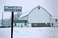
Snowy landscape at the northern end of Main Street
-
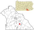
Location of Winterstown in York County and Pennsylvania
See also
 In Spanish: Winterstown (Pensilvania) para niños
