Conewago Creek (west) facts for kids
Quick facts for kids Conewago Creek |
|
|---|---|

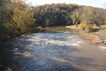
facing south and upstream from bridge on Kunkle Mill Road, York County
|
|
| Country | Carroll County, Maryland and Adams and York Counties, Pennsylvania, United States |
| Physical characteristics | |
| Main source | Franklin Township, Adams County, Pennsylvania 1,440 feet (440 m) |
| River mouth | Susquehanna River at York Haven, Pennsylvania 259 feet (79 m) |
| Length | 80 miles (130 km) |
| Basin features | |
| Basin size | 515 square miles (1,330 km2) |
Conewago Creek is a long stream, about 80.2-mile (129.1 km) (129 km) in length. It flows into the Susquehanna River in Pennsylvania, USA. This creek starts in Adams County and flows through York County. A small part of its water also comes from Carroll County, Maryland.
The creek begins high up, at about 1,440 feet (440 m) (439 meters) above sea level. This is near Caledonia State Park. It ends when it joins the Susquehanna River at York Haven, at a lower elevation of 259 feet (79 m) (79 meters).
Contents
What Does "Conewago" Mean?
The name Conewago comes from the Lenape people. It means "at the rapids." But the rapids aren't actually on Conewago Creek itself! Instead, the name refers to the Conewago Falls. These falls are in the Susquehanna River, just past where the creek joins it.
There's actually another creek with the same name, Conewago Creek, on the other side of the Susquehanna River. It's only about 1.6 miles (2.6 km) (2.6 km) north of this Conewago Creek's mouth.
Where Does Conewago Creek Flow?
Conewago Creek starts in Franklin Township, Adams County. For about 39 miles (63 km) (63 km), it flows towards the east. Then, it turns and flows northeast for another 41 miles (66 km) (66 km). Finally, it reaches its end at the Susquehanna River in York County.
Understanding the Conewago Creek Watershed
A watershed is an area of land where all the water drains into a single river or stream. The Conewago Creek watershed covers a large area of 515 square miles (1,330 km2) (1,334 sq km). Most of this area is in Pennsylvania. Only a small part, about 5.22 square miles (13.5 km2) (13.5 sq km), is in Maryland.
This watershed is part of an even bigger one: the Chesapeake Bay drainage basin. This means all the water from Conewago Creek eventually flows into the Susquehanna River, and then into the Chesapeake Bay. Conewago Creek and its smaller streams drain about half of Adams County and over a quarter of York County.
Smaller Streams Joining Conewago Creek
Many smaller streams, called tributaries, flow into Conewago Creek. They add to its water and help form its watershed. Some of these important tributaries include:
- Opossum Creek
- South Branch Conewago Creek
- Bermudian Creek
- Beaver Creek
- Bennett Run
- Little Conewago Creek (west)
Fun Things to Do at Conewago Creek
Conewago Creek offers some cool outdoor activities, especially if you like being on the water or fishing!
Canoeing and Kayaking
If you enjoy canoeing or kayaking, Conewago Creek can be a good spot. You need to make sure the water level is high enough, usually in spring or after heavy rain. There are about 69 miles (111 km) (111 km) of water that are good for paddling. These sections are considered "Class A" to "Class 1" whitewater, which means they are mostly calm with some easy rapids.
Fishing
Conewago Creek is a popular place for fishing. A special part of the creek in Adams County is known as "approved trout waters." This means the Pennsylvania Fish and Boat Commission adds trout to these waters, and you can fish for them during trout season. Further downstream in Adams County, there's also a "catch and release" section. This means you can fish, but you must let the fish go afterwards.
The creek is home to many different kinds of fish, including:
- Smallmouth bass
- Walleye
- Bluegill
- Rock bass
- Sunfish
- Carp
- Channel catfish
- Flathead catfish
- Yellow perch
- Rainbow trout
- Muskellunge
- Crappie
Bridges and Dams on the Creek
Many bridges cross Conewago Creek, and there are also several dams along its path. Dams help control water flow and can create ponds or lakes. Some of these structures have specific names:
- Ganoga Bridge
- East Berlin Dam
- Browns Dam
- Dicks Dam
- Detters Mill Dam
- Sharrer Mill Dam
- Harlacher Bridge
- Sheeps Bridge
- Iron Bridge near Biglerville
One bridge, Kuhn's Fording Bridge, used to be there but has since been removed.
 | Delilah Pierce |
 | Gordon Parks |
 | Augusta Savage |
 | Charles Ethan Porter |

