
Frederick County, Maryland facts for kids
Quick facts for kids
Frederick County
|
|||
|---|---|---|---|

Downtown Frederick with the Blue Ridge Mountains in the distance in June 2014
|
|||
|
|||
| Nicknames:
"Frederick", "FredCo"
|
|||

Location of Frederick County in Maryland
|
|||
| Country | United States | ||
| State | Maryland | ||
| Founded | June 10, 1748 | ||
| County seat | Frederick | ||
| Area | |||
| • Total | 667 sq mi (1,730 km2) | ||
| • Land | 660 sq mi (1,700 km2) | ||
| • Water | 7.2 sq mi (19 km2) | ||
| Population
(2020)
|
|||
| • Total | 271,717 | ||
| • Density | 407.37/sq mi (157.29/km2) | ||
| Time zone | Eastern (EST) | ||
| • Summer (DST) | EDT | ||
| ZIP Codes |
21701, 21702, 21703, 21704, 21705, 21709
|
||
| Area codes | 301, 240 | ||
| Congressional districts | 6th | ||
| Website | http://www.FrederickCountyMD.gov/ | ||


Frederick County is a county located in Maryland, United States. It's a busy place with a growing population. As of the 2020 U.S. census, about 271,717 people lived here. The main city and county seat is Frederick. This county is part of the larger Capital region of the state.
Since the 1980s, many people have moved to Frederick County. It shares borders with Pennsylvania to the north and Virginia to the southwest. It's also home to Catoctin Mountain Park, where Camp David (a special retreat for U.S. presidents) is located, and Fort Detrick, a U.S. Army base.
Contents
What's in a Name?
The name of Frederick County and its main city, Frederick, isn't completely certain. It was likely named after either Frederick, Prince of Wales, or Frederick Calvert, 6th Baron Baltimore.
A Look Back in Time
Frederick County was created in 1748 by the Province of Maryland. It was formed from parts of what were then Prince George's County and Baltimore County.
After the United States became independent in 1776, Frederick County was divided into three parts. The western part became Washington County, named after George Washington. The southern part became Montgomery County, named after another general from the American Revolutionary War, Richard Montgomery. The northern part remained Frederick County.
Later, in 1837, a piece of Frederick County was combined with a piece of Baltimore County to form Carroll County. This new county is located east of today's Frederick County. Many historic places in the county are listed on the National Register of Historic Places.
Exploring Frederick County's Geography
According to the U.S. Census Bureau, Frederick County covers a total area of about 667 square miles. Most of this, about 660 square miles, is land, and a small part (about 7.2 square miles) is water. It's actually the largest county in Maryland when you look at its land area.
Frederick County sits right where two different land regions meet: the Piedmont Plateau Region and the Appalachian Mountains. The county has two main mountain ridges, Catoctin Mountain and South Mountain. These are like extensions of the Blue Ridge Mountains. Between these two ridges lies the Middletown Valley.
There are many interesting places to visit in the Frederick area. These include the Clustered Spires, a monument dedicated to Francis Scott Key, the National Museum of Civil War Medicine, and the battlefields of Monocacy National Battlefield and South Mountain. You can also visit the Schifferstadt Architectural Museum.
Neighboring Counties
Frederick County shares its borders with several other counties:
- Adams County, Pennsylvania (north)
- Carroll County (east)
- Franklin County, Pennsylvania (northwest)
- Montgomery County (south)
- Washington County (west)
- Loudoun County, Virginia (southwest)
Special Protected Areas
The county is home to several national protected areas:
- Catoctin Mountain Park
- Chesapeake and Ohio Canal National Historical Park (part of it)
- Monocacy National Battlefield
Main Roads and Highways
_from_the_overpass_for_Mussetter_Road_in_Linganore,_Frederick_County,_Maryland.jpg)
 I-70
I-70 I-270
I-270 US 15
US 15 US 15 Bus.
 US 40
US 40
US 40 Alt. US 340
 MD 17
MD 17 MD 26
MD 26 MD 27
MD 27 MD 28
MD 28 MD 31
MD 31 MD 75
MD 75 MD 76
MD 76 MD 77
MD 77 MD 79
MD 79 MD 80
MD 80 MD 85
MD 85 MD 144
 MD 180
 MD 194
 MD 355
 MD 355 Bus.
 MD 550
Who Lives in Frederick County?
| Historical population | |||
|---|---|---|---|
| Census | Pop. | %± | |
| 1790 | 30,791 | — | |
| 1800 | 31,523 | 2.4% | |
| 1810 | 34,437 | 9.2% | |
| 1820 | 40,459 | 17.5% | |
| 1830 | 45,789 | 13.2% | |
| 1840 | 36,405 | −20.5% | |
| 1850 | 40,987 | 12.6% | |
| 1860 | 46,591 | 13.7% | |
| 1870 | 47,572 | 2.1% | |
| 1880 | 50,482 | 6.1% | |
| 1890 | 49,512 | −1.9% | |
| 1900 | 51,920 | 4.9% | |
| 1910 | 52,673 | 1.5% | |
| 1920 | 52,541 | −0.3% | |
| 1930 | 54,440 | 3.6% | |
| 1940 | 57,312 | 5.3% | |
| 1950 | 62,287 | 8.7% | |
| 1960 | 71,930 | 15.5% | |
| 1970 | 84,927 | 18.1% | |
| 1980 | 114,792 | 35.2% | |
| 1990 | 150,208 | 30.9% | |
| 2000 | 195,277 | 30.0% | |
| 2010 | 233,385 | 19.5% | |
| 2020 | 271,717 | 16.4% | |
| 2023 (est.) | 293,391 | 25.7% | |
| U.S. Decennial Census 1790-1960 1900-1990 1990-2000 2010 2020 |
|||
Frederick County has seen a fast increase in its population since the 1980s. This includes more people from different ethnic backgrounds.
In 2020, the county had 271,717 people. Most residents were White (about 67.58%). There were also significant numbers of Black or African American people (about 9.94%), Asian people (about 4.94%), and people of mixed races (about 4.98%). About 11.82% of the population identified as Hispanic or Latino.
In 2010, there were 233,385 people living in the county. The average household had 2.70 people, and the average family had 3.17 people. The median age was 38.6 years. The median household income was $81,686, and the median family income was $95,036. This means half of the households earned more than this amount, and half earned less. Only a small percentage of the population, about 4.8%, lived below the poverty line.
How Frederick County Makes Money
Frederick County has a strong economy. Many people work in different industries here. Some of the largest employers include Fort Detrick, which is a U.S. Army base and a research center, and Frederick Memorial Healthcare System. Other big companies like Wells Fargo Home Mortgage, Leidos Biomedical Research, and Bechtel also provide many jobs.
There are also many well-known stores and businesses like Walmart, Sam's Club, State Farm Insurance, AstraZeneca, Giant Food, Costco Wholesale, Wegmans Food Markets, and Home Depot.
Frederick County is also a leader in farming, especially for milk production. The county's dairy farms produce about one-third of all the milk in Maryland! However, the dairy farming business can be tough, and the county has seen some dairy farms close over time.
Places to Live in Frederick County

Frederick County has several cities, towns, and smaller communities where people live.
Cities
Towns
Village
Census-designated places
These are areas that the Census Bureau recognizes as communities, but they are not officially incorporated as cities or towns:
Unincorporated communities
These are smaller communities that are not officially part of a city or town:
Learning in Frederick County
The public schools in the county are managed by Frederick County Public Schools. There's also a special statewide school for the deaf, called Maryland School for the Deaf, located in Frederick.
Famous People from Frederick County
Many notable people have come from Frederick County, including:
- Shadrach Bond, who was the first governor of Illinois
- Lawrence Everhart, a soldier who fought in the American Revolutionary War
- Barbara Fritchie, a Unionist who was the subject of a famous 1863 Civil War poem by John Greenleaf Whittier
- Thomas Johnson, who was a delegate to the First Continental Congress and later a U.S. Supreme Court judge
- Francis Scott Key, who wrote "The Star-Spangled Banner" in 1814. This song later became the U.S. national anthem in 1931.
- Adamson Tannehill, a soldier and a member of the United States House of Representatives
- Roger B. Taney, who was the fifth U.S. Supreme Court chief justice
Images for kids
-
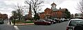
Frederick, the county seat and largest community in Frederick County


_between_Cedar_Street_and_Poplar_Street_in_Myersville,_Frederick_County,_Maryland.jpg)
See also
 In Spanish: Condado de Frederick (Maryland) para niños
